Putney Village Historic District | |
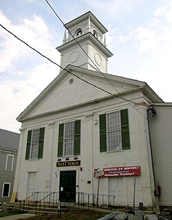
Location | Westminster W Rd., US 5, Christian Sq., Old US 5, and Depot Rd., Putney, Vermont |
---|---|
Coordinates | 42°58′30″N72°31′27″W / 42.97500°N 72.52417°W |
Area | 140 acres (57 ha) |
Built | 1753 |
Architectural style | Greek Revival, Late Victorian, Federal |
NRHP reference No. | 86000324 [2] |
Added to NRHP | February 20, 1986 |
The Putney Village Historic District encompasses most of the main village and town center of Putney, Vermont. Settled in the 1760s, the village saw its major growth in the late 18th and early 19th century, and includes a cohesive collection with Federal and Greek Revival buildings, with a more modest number of important later additions, including the Italianate town hall. The district was listed on the National Register of Historic Places in 1986. [2]
The town of Putney was chartered by New Hampshire colonial governor Benning Wentworth in 1753, but significant settlement did not begin until after French and Indian War ended in 1760.
The town arose in a large plain on the west side of the Connecticut River, above the mouth of Sacketts Brook. A falls on the brook provided water power for early mills, and it is around that point that the main village was formed. Because the town did not have abundant sources of water power, it was largely bypassed by the Industrial Revolution of the mid-19th century, and remained largely rural in character. The village's character is defined by the Federal and Greek Revival styles popular during its most significant period of growth, the late 18th to mid-19th century. [3]
The historic district covers most of the present-day village of Putney. The spine of the district is United States Route 5, Kimball Hill, and Westminster West Road, roughly from Sand Hill Road in the north to the Interstate 91 interchange to the south. It includes a number of buildings on adjacent side roads, including all of Old Depot Road (a spur road terminated near the highway), and a portion of Old Route 5. Most of the residences in the district are Greek Revival in style, although there are a fair number of earlier Federal period buildings, as well as a handful of later ones, including a few vernacular Queen Anne houses. There are two churches (Methodist and Congregationalist), both Greek Revival buildings dating to the 1840s. Not surviving is an 1841 chapel of a Christian perfection movement, which was an active religious force here; its adherents later founded the Oneida Community in Upstate New York; the building burned in 1970. The town hall, the village's main municipal civic structure, is an Italianate hall built in 1871, and the large Colonial Revival Central School was added in 1906. [3]
Putney is a town in Windham County, Vermont, United States. The population was 2,617 at the 2020 census.
The South Britain Historic District encompasses the core of the unincorporated village of South Britain in Southbury, Connecticut, United States. The village arose in the 18th century as an industrial center serving the surrounding agricultural community, powered by the Pomperaug River, and rivalled the town center of Southbury in importance. The district was listed on the National Register of Historic Places in 1987.
The Hazardville Historic District is a historic district in the Hazardville section of Enfield, Connecticut, United States, that is listed on the National Register of Historic Places.
The Heath Center Historic District encompasses a rural village with predominantly 18th- and 19th-century structures in Heath, a small agricultural town in hills of northwestern Franklin County, Massachusetts, United States. The district is centered on the junction of several roads, around which the center of the town grew. South Road arrives from the south, East Main Street and Bray Road from the east, Ledge Road from the north, and West Main Street from the west.
The Orleans County Courthouse Historic District is one of two located in downtown Albion, New York, United States. Centered on Courthouse Square, it includes many significant buildings in the village, such as its post office and churches from seven different denominations, one of which is the tallest structure in the county. Many buildings are the work of local architect William V.N. Barlow, with contributions from Solon Spencer Beman and Andrew Jackson Warner. They run the range of architectural styles from the era in which the district developed, from Federal to Colonial Revival.
Florona Grange No. 540 Hall is a historic Grange hall and former church on Monkton Road in Monkton, Vermont. Built in 1811 as the Monkton Borough Baptist Church, it is the second-oldest church in Addison County. it is a fine example of Federal architecture with later Greek Revival additions. Its initial design is based closely on designs published by Asher Benjamin. The building was added to the National Register of Historic Places in 1989.
The Starksboro Village Meeting House is a historic church and town hall on Vermont Route 116 in the village center of Starksboro, Vermont. It was built in 1838 as a cooperative venture between three church congregations and the town, and is a fine local example of Gothic Revival architecture. It was listed on the National Register of Historic Places in 1985.
The Dundee Township Historic District is a set of sixty-five buildings in Dundee Township, Kane County Illinois. Buildings in the district are found in East Dundee, West Dundee, and Carpentersville. The district represents the development of the upper Fox River Valley from 1870 to the 1920s. Dundee Township became an important industrial area, especially following the construction of the Dundee Brick Company in West Dundee and the Illinois Iron and Bolt Company in Carpentersville. Also included in the district are a variety of Queen Anne, Italianate, and Greek Revival style houses and Gothic Revival churches. The majority of the historic district lies within the boundaries of West Dundee. It was added to the National Register of Historic Places in 1975.
The Alfred Historic District is an historic district encompassing the historic village center of Alfred, Maine. The roughly Y-shaped district radiates from the junction of Oak Street with Kennebunk, Waterboro, and Saco Roads, and is characterized by high-quality 19th-century wood-frame buildings. The district was added to the National Register of Historic Places in 1983.
The Grafton Village Historic District encompasses the historic village center of the town of Grafton, Vermont. The village was developed in the early-to-mid 19th century, and has retained the character of that period better than many small communities in the state. The district was listed on the National Register of Historic Places in 2010.
The Searsport Historic District encompasses a collection of well-preserved mid-to-late 19th-century commercial buildings in the center of Searsport, Maine. They represent the community's peak period of prosperity, when it was a leading shipping and shipbuilding center. The district was listed on the National Register of Historic Places in 1979.
The East Arlington Village Historic District encompasses the historic core of a 19th-century village in Arlington and Sunderland, Vermont, United States. It is centered on Old Mill Road, and developed as a mill village beginning in the 18th century. It was listed on the National Register of Historic Places in 1996.
The Danby Village Historic District encompasses much of the town center of Danby, Vermont. It is centered on a stretch of Main Street, roughly between Depot Street and Brook Road. The village has a cohesive collection of mid-19th century architecture, mostly residential, with a modest number of later additions. The district was listed on the National Register of Historic Places in 1983.
The Strafford Village Historic District encompasses the historic village center of Strafford, Vermont, United States. Founded in 1768, the village center was developed in the 1790s, and saw most of its growth before 1840, resulting in a fine assortment of predominantly Greek Revival buildings. Notable exceptions include the 1799 meetinghouse, and the Justin Smith Morrill Homestead, a fine example of Gothic Revival architecture built by native son Justin Smith Morrill. The district, centered on the town green at the junction of Morrill Highway and Brook Road, was listed on the National Register of Historic Places in 1974.
The Thetford Center Historic District encompasses the village of Thetford Center in Thetford, Vermont. The village contains a well-preserved collection of early to mid-19th century architecture, a legacy of its period of greatest prosperity as an agricultural and industrial center. It was listed on the National Register of Historic Places in 1998.
The Tunbridge Village Historic District encompasses the early 19th-century village center of Tunbridge, Vermont. Stretched linearly along Vermont Route 110, the largely agricultural village reached its peak population around 1820, and was bypassed by the railroads, limiting later development. It was listed on the National Register of Historic Places in 1994.
The Plainfield Village Historic District encompasses a significant portion of the village of Plainfield, Vermont. Located in northernmost Plainfield on United States Route 2, the village grew in the 19th century as a mill town and service community for the surround agricultural areas, and has a well-preserved collection of Greek Revival and Italianate architecture. It was listed on the National Register of Historic Places in 1983.
The Warren Village Historic District encompasses the village center of Warren, Vermont, United States. Stretched mainly along Main Street east of the Mad River, it is a well-preserved 19th-century mill village, although most of its period mill infrastructure has been lost. The district has good examples of Greek Revival, Italianate, and Second Empire architecture. It was listed on the National Register of Historic Places in 1992.
The Asbury Historic District is a 288 acres (117 ha) historic district encompassing the community of Asbury in Franklin Township of Warren County, New Jersey. It is bounded by County Route 632, County Route 643, Maple Avenue, Kitchen Road, and School Street and extends along the Musconetcong River into Bethlehem Township of Hunterdon County. It was listed on the National Register of Historic Places on March 19, 1993 for its significance in architecture, industry, religion, community development, politics/government, and commerce. The district includes 141 contributing buildings, a contributing structure, two contributing sites, and four contributing objects.
The Gill Center Historic District encompasses the historic 19th-century village center of Gill, Massachusetts. The district is focused on Main Road near its junction with River Road, in the central northern part of the town, and has served as the community's center since its incorporation in 1793. The district was listed on the National Register of Historic Places in 1999; it features a variety of mainly Greek Revival and later Victorian architecture, as well as some 20th-century Colonial Revival buildings.