WikiMili
List of mountains of Vermont
Last updated
January 24, 2026
This is a list of
mountains
in the
U.S. state
of
Vermont
.
Contents
List
Gallery
Mount Mansfield photos
Killington Peak photos
Camel's Hump Mountain Photos
Woodbury Mountain Photos
See also
References
List
Mountain
Image
Height (ft.)
Height (m)
Town
County
Mount Mansfield
4,393
1,339
Underhill
Chittenden
Killington Peak
4,235
1,291
Killington
Rutland
Mount Ellen
4,083
1,244
Warren
Washington
Camel's Hump
4,083
1,244
Duxbury
Washington
Mount Abraham
4,006
1,221
Lincoln
Addison
Lincoln Peak
3,975
1,212
Warren
Washington
Pico Peak
3,957
1,206
Killington
Rutland
Bear Head
3,940
1,201
Stowe
Lamoille
Stratton Mountain
3,940
1,201
Stratton
Windham
Little Killington
3,939
1,201
Mendon
Rutland
North Stratton
3,875
1,181
Stratton
Windham
Jay Peak
3,858
1,176
Westfield
Orleans
Equinox Mountain
3,840
1,170
Manchester
Bennington
Mendon Peak
3,840
1,170
Mendon
Rutland
Bread Loaf Mountain
3,835
1,169
Ripton
Addison
Nancy Hanks Peak
3,812
1,162
Warren
Washington
Skye Peak
3,800
1,158
Killington
Rutland
Big Jay
3,786
1,154
Montgomery
Franklin
Mount Wilson
3,780
1,152
Ripton
Addison
Dorset Mountain
3,760
1,146
Danby
Rutland
Glastenbury Mountain
3,748
1,142
Glastenbury
Bennington
Shrewsbury Peak
3,720
1,134
Shrewsbury
Rutland
Whiteface Mountain
3,715
1,132
Jeffersonville
Lamoille
Ethan Allen Mountain
3,688
1,124
Duxbury
Washington
Bolton Mountain
3,680
1,122
Bolton
Chittenden
Stark Mountain
3,662
1,116
Fayston
Washington
Mount Putnam
3,642
1,110
Worcester
Washington
Madonna Peak
3,640
1,109
Jeffersonville
Lamoille
Mount Grant
3,623
1,104
Lincoln
Addison
Rams Head
3,600
1,097
Killington
Rutland
Snowden Peak
3,592
1,095
Killington
Rutland
Mount Snow
3,586
1,093
West Dover
Hunger Mountain
3,539
1,079
Worcester
Mount Roosevelt
3,528
1,075
Ripton
Farr Peak
3,522
1,074
Chittenden
Bloodroot Mountain
3,485
1,062
Chittenden
Mount Cleveland
3,482
1,061
Lincoln
Mount Ira Allen
3,460
1,055
Duxbury
Haystack Mountain
3,445
1,050
Wilmington
East Mountain
3,439
1,048
East Haven
North Jay Peak
3,438
1,048
Jay
Peru Peak
3,429
1,045
Peru
Battell Mountain
3,428
1,045
Ripton
Ricker Mountain
3,410
1,039
Waterbury
Styles Peak
3,394
1,034
Peru
Spruce Peak
3,390
1,033
Stowe
Morse Mountain
3,380
1,030
Jeffersonville
Signal Mountain
3,370
1,027
Groton
Mount Carmel
3,365
1,026
Chittenden
Dewey Mountain
3,360
1,024
Underhill
Belvidere Mountain
3,360
1,024
Lowell
Ludlow Mountain
3,344
1,019
Ludlow
Okemo Mountain
3,344
1,019
Ludlow
Cape Lookoff Mountain
3,340
1,018
Goshen
Gore Mountain
3,332
1,016
Norton
Cold Hollow Mountain
3,330
1,015
Belvidere
Boyce Mountain
3,323
1,013
Ripton
Bald Mountain
3,315
1,010
Westmore
Bromley Mountain
3,284
1,001
Peru
Worcester Mountain
3,274
998
Worcester
Burke Mountain
3,267
996
Burke
Bear Mountain
3,295
1,004
Killington
Burnt Rock Mountain
3,168
966
Moretown
Vista Peak
3,150
960
Waterbury
Monadnock Mountain
3,148
960
Lemington
Seneca Mountain
3,146
959
Burke
Mount Ascutney
3,144
958
Windsor
/
Weathersfield
Mount Mayo
3,143
958
Underhill
Mount Aeolus
3,230
985
Dorset
Woodward Mountain
3,110
948
Waterbury
Grass Mountain
3,109
948
Arlington
Burke Mountain (West Peak)
3,097
944
Burke
East Haven Mountain
3,070
936
East Haven
Little Jay
3,045
928
Montgomery
Mount Tabor
3,043
928
Peru
Spruce Mountain
3,037
926
Plainfield
Gilpin Peak
3,015
919
Westfield
Sterling Peak
3,010
917
Jeffersonville
Tillotson Peak
2,992
912
Tillotson
Umpire Mountain
2,967
904
Victory
Molly Stark Mountain
2,967
904
Fayston
Mount Clark
2,960
902
Underhill
Buchanan Mountain
2,940
896
Westfield
Bone Mountain
2,910
887
Waterbury
Domeys Dome
2,894
882
Westfield
Baby Stark Mountain
2,863
873
Fayston
Buckball Peak
2,858
871
Danby
Bald Mountain
2,857
871
Woodford
Glebe Mountain
2,850
869
Londonderry
South Buckball Peak
2,841
866
Danby
Baker Peak
2,828
862
Danby
Consultation Peak
2,810
856
Bennington
Laraway Mountain
2,796
852
Johnson
Deer Leap Mountain
1,825
556
Bristol
Deer Leap Mountain
2,787
849
Killington
Mount Pisgah
2,752
839
Westmore
Kirby Mountain
2,750
838
Kirby
The Dome
2,748
838
Pownal
Prospect Mountain
2,740
835
Woodford
Jackson Gore Peak
2,725
831
Ludlow
Brousseau Mountain
2,723
830
Norton
Kirby Mountain
2,720
829
Burke
Bull Mountain
2,710
826
Burke
White Rocks Mountain
2,680
817
Wallingford
Mount Hor
2,654
809
Sutton
Mount Moosalamoo
2,650
808
Brandon
Stannard Mountain
2,618
798
Stannard
[
1
]
Elmore Mountain
2,608
795
Elmore
Mount Norris
2,493
760
Eden Mills
Woodbury Mountain
2,480
756
Woodbury
Sunrise Mountain
2,456
749
Killington
Mount Olga
2,418
737
Wilmington
Hogback Mountain
2,410
735
Marlboro
Mount Hunger
2,403
732
Barnard
Wheeler Mountain
2,365
721
Sutton
Hooker Mountain
2,326
709
Peacham
Mount Anthony
2,343
714
Bennington
Tiny Mountain
2,320
707
Mount Holly
Bowen Mountain
2,303
702
Eden
Burnt Mountain
2,257
688
Marshfield
Hardwood Mountain
2,244
684
Marshfield
Cherry Knoll
2,236
682
Killington
Barton Mountain
2,235
681
Barton
Fletcher Mountain
2,150
655
Fletcher
Bean Mountain
2,136
651
Eden
Marshfield Mountain
2,119
646
Marshfield
Sugarloaf Mountain
2,115
645
Warren
Spruce Peak
2,040
622
Manchester
Stimson Mountain
2,000
610
Bolton
Central Mountain
1,995
608
Marlboro
Deer Mountain
1,988
606
Peacham
Owlshead Mountain
1,952
595
Peacham
Drew Mountain
1,932
589
Marshfield
Haystack Mountain (Pawlet)
1,919
585
Pawlet
Split Rock Mountain
1,890
576
Granby
Gile Mountain
1,873
571
Norwich
Little Deer Mountain
1,759
536
Peacham
The Fox Cobble
1,587
484
Rutland County
Buffalo Mountain
1,555
474
Caledonia County
Mays Mountain
1,522
464
Marshfield
Mount Ephraim
1,490
454
Springfield
Snake Mountain
1,287
392
Addison
Mount Tom
1,250
381
Woodstock
Mount Philo
968
295
Charlotte
Pease Mountain
820
250
Charlotte
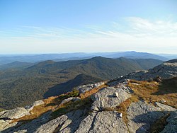
Gallery
Mount Mansfield photos
Aerial eastward view from Jericho
Top of Mount Mansfield facing west
Eastward view of "The Chin"
View from the northeast
Top of Mount Mansfield facing south
Killington Peak photos
Top of Killington facing north
Top of Killington facing west
Top of Killington facing west
Camel's Hump Mountain Photos
Eastward view of Camel's Hump Mountain from South Burlington
Westward view of the summit
View from the northwest
Woodbury Mountain Photos
View of Woodbury from Hardwick Farms Road facing WSW
View from Mountain View Rd in Hardwick facing west
This list is
incomplete
; you can help by
adding missing items
.
(
November 2018
)
See also
List of mountains of the Appalachians
References
↑
"Stannard Mountain-East Peak - Peakbagger.com"
.
AMC NE 4000 Footer List
[
1
]
v
t
e
State
of
Vermont
Montpelier
(capital)
Regions
Champlain Valley
Green Mountains
Mount Mansfield
Northeast Kingdom
Counties
Addison
Bennington
Caledonia
Chittenden
Essex
Franklin
Grand Isle
Lamoille
Orange
Orleans
Rutland
Washington
Windham
Windsor
Cities
Barre
Burlington
(
metropolitan area
)
Essex Junction
Montpelier
Newport
Rutland
St. Albans
South Burlington
Vergennes
Winooski
Towns
(pop. <5000)
Barre
Bennington
Brattleboro
Colchester
Essex
Fairfax
Hartford
Lyndon
Jericho
Middlebury
Milton
Morristown
Northfield
Shelburne
Springfield
St. Albans
St. Johnsbury
Stowe
Swanton
Waterbury
Williston
Festivals
Vermont State Fair
Green Mountain Film Festival
Strolling of the Heifers
Topics
Outline
Climate change
Flag
Geography
mountains
Government
constitution
delegations
History
Vermont National Guard
Vermont Air National Guard
Vermont State Guard
People
Symbols
Tallest buildings
Tourist attractions
Vermont Republic
coinage
flag
Stella quarta decima
Villages
Society
Abortion
Cannabis
Culture
Crime
Demographics
Economy
Education
Elections
Gun laws
LGBT rights
Politics
Vermont
portal
v
t
e
Mountain peaks of the United States of America
States
Alabama
Alaska
Arizona
Arkansas
California
Colorado
Connecticut
Delaware
Florida
Georgia
Hawaii
Idaho
Illinois
Indiana
Iowa
Kansas
Kentucky
Louisiana
Maine
Maryland
Massachusetts
Michigan
Minnesota
Mississippi
Missouri
Montana
Nebraska
Nevada
New Hampshire
New Jersey
New Mexico
New York
North Carolina
North Dakota
Ohio
Oklahoma
Oregon
Pennsylvania
Rhode Island
South Carolina
South Dakota
Tennessee
Texas
Utah
Vermont
Virginia
Washington
West Virginia
Wisconsin
Wyoming
Federal district
Washington, D.C.
Territories
American Samoa
Guam
Northern Mariana Islands
Puerto Rico
U.S. Virgin Islands
v
t
e
Mountain peaks of North America
Sovereign states
Antigua and Barbuda
Bahamas
Barbados
Belize
Canada
Costa Rica
Cuba
Dominica
Dominican Republic
El Salvador
Grenada
Guatemala
Haiti
Honduras
Jamaica
Mexico
Nicaragua
Panama
Saint Kitts and Nevis
Saint Lucia
Saint Vincent and the Grenadines
Trinidad and Tobago
United States
Dependencies and
other territories
Anguilla
Aruba
Bermuda
Bonaire
British Virgin Islands
Cayman Islands
Curaçao
Greenland
Guadeloupe
Martinique
Montserrat
Puerto Rico
Saint Barthélemy
Saint Martin
Saint Pierre and Miquelon
Saba
Sint Eustatius
Sint Maarten
Turks and Caicos Islands
United States Virgin Islands
v
t
e
Mountains of Vermont
Green Mountains
Presidential Range
Mount Abraham
Mount Cleveland
Mount Grant
Mount Roosevelt
Mount Wilson
Others
Big Jay
Bolton Mountain
Bread Loaf Mountain
Bromley Mountain
Camel's Hump
Glastenbury Mountain
Haystack Mountain
Hogback Mountain
Jay Peak
Killington Peak
Lincoln Peak
Mendon Peak
Mount Ellen
Mount Mansfield
Mount Snow
Pico Peak
Prospect Mountain
Shrewsbury Peak
Stark Mountain
Stratton Mountain
Taconic Mountains
Dorset Mountain
Equinox Mountain
Grass Mountain
Mount Aeolus
Snake Mountain
White Rock
Others
Burke Mountain
East Mountain
Gile Mountain
Gore Mountain
Ludlow Mountain
Monadnock Mountain
Mount Ascutney
Mount Ephraim
Mount Hor
Mount Horrid
Mount Pisgah
Mount Putnam
Mount Tom
Notre Dame Mountains
Okemo Mountain
Signal Mountain
Terrible Mountain
↑
USGS Summary Report Buffalo Mountain Feature ID:2830210
This page is based on this
Wikipedia article
Text is available under the
CC BY-SA 4.0
license; additional terms may apply.
Images, videos and audio are available under their respective licenses.