Westmore, Vermont

Last updated

Westmore, Vermont
Town
Lake Willoughby, Westmore, Vermont, 2015.jpg
Westmore, Vermont (Mount Pisgah, Lake Willoughby, Mount Hor)
Westmore vt highlight.png
Located in Orleans County, Vermont
Map of USA VT.svg
Location of Vermont with the U.S.A.
Coordinates: 44°45′25″N72°1′34″W / 44.75694°N 72.02611°W / 44.75694; -72.02611
Country United States
State Vermont
County Orleans
CharteredAugust 17, 1781
Area
  Total37.5 sq mi (97.0 km2)
  Land34.5 sq mi (89.4 km2)
  Water2.9 sq mi (7.6 km2)
Elevation
1,170 ft (554 m)
Population
 (2020)
  Total357
  Density10/sq mi (4.0/km2)
  Households
136
  Families
85
Time zone UTC-5 (EST)
  Summer (DST) UTC-4 (EDT)
ZIP codes
05822, 05860
Area code 802
FIPS code 50-81700 [1]
GNIS feature ID1462254 [2]

Westmore is a town in Orleans County, Vermont, United States. The population was 357 at the 2020 census, [3] making it the least populated and least densely populated town in the county. The town contains one unincorporated village clustered around Lake Willoughby. [4]

Contents

History

Originally named Westford, the town was chartered on August 17, 1781. Since Chittenden County had a town named Westford, in 1787 the name was changed to Westmore.

The first vacation house was built on the lake in 1860. It is known as the Cheney House, named after an owner in the late 19th century. [5]

Westmore never attracted many settlers. The town's peak population was in the census year of 1880 with 485 people.

Before he became famous, Robert Frost camped here in the summer of 1909 with his family. [6]

Songadeewin Camp for girls was located here from 1921–1975. [7]

Electricity became available at the south end of the lake, from West Burke, c.1934. [8]

In 1970, the state of Vermont acquired 7,600 acres (3,100 ha) as part of Willoughby State Forest, which included the Cheney House. [5]

Nudity is legal throughout Vermont, [9] [10] though in 2007–2008, the town discussed whether to ban nudity, aimed at sunbathers on the south beach of Lake Willoughby. [11]

Having closely approximated the state's voting percentages for governor, in 2006, and president in 2004, Westmore was considered one of six "bellwether" towns for the 2008 general election. [12]

Geography

According to the United States Census Bureau, the town has a total area of 37.5 square miles (97.0 km2), of which 34.5 square miles (89.4 km2) is land and 2.9 square miles (7.6 km2) (7.85%) is water.

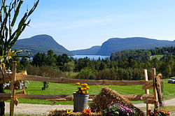
One of the town's most prominent features is Lake Willoughby. The relatively young 12,000-year-old glacier-carved lake is flanked on the east by Mount Pisgah 2,752 feet (839 m) and the west by Mount Hor 2,654 feet (809 m). The mountains, which have hundreds of feet of rock cliffs, are located in the Willoughby State Forest and the cliffs have been designated a National Natural Landmark. In recent decades, several peregrine falcons have been found there.

Local mountains also include Goodwin 2,936 feet (895 m), Bald 3,316 feet (1,011 m), Hedgehog 2,201 feet (671 m), Haystack 2,713 feet (827 m), and Bartlett 2,047 feet (624 m).

The town has a local weather recording and reporting station. [13]

Demographics

Historical population
CensusPop.Note
1810 126
1830 132
1840 122−7.6%
1850 15224.6%
1860 324113.2%
1870 41227.2%
1880 48016.5%
1890 395−17.7%
1900 390−1.3%
1910 331−15.1%
1920 287−13.3%
1930 224−22.0%
1940 2240.0%
1950 210−6.2%
1960 179−14.8%
1970 1958.9%
1980 25731.8%
1990 30518.7%
2000 3060.3%
2010 35014.4%
2020 3572.0%
U.S. Decennial Census [14] [15]

As of the census [1] of 2000, there were 306 people, 133 households, and 90 families residing in the town. The population density was 8.9 people per square mile (3.4/km2). There were 530 housing units at an average density of 15.4 per square mile (5.9/km2).

There were 133 households, out of which 20.3% had children under the age of 18 living in them, 58.6% were married couples living together, 6.8% had a female householder with no husband present, and 32.3% were non-families. 26.3% of all households were made up of individuals, and 6.8% had someone living alone who was 65 years of age or older. The average household size was 2.30 and the average family size was 2.74.

In the town, the population was spread out, with 16.7% under the age of 18, 7.8% from 18 to 24, 22.5% from 25 to 44, 36.3% from 45 to 64, and 16.7% who were 65 years of age or older. The median age was 46 years. For every 100 females, there were 100.0 males. For every 100 females age 18 and over, there were 112.5 males.

Economy

Personal income

The median income for a household in the town was $27,375, and the median income for a family was $38,333. Males had a median income of $26,875 versus $18,958 for females. The per capita income for the town was $14,522. About 7.8% of families and 14.6% of the population were below the poverty line, including 25.8% of those under the age of eighteen and 3.8% of those 65 or over.

Tourism

The town is first in the county with the highest percentage of second home ownership. The county is tied for first in the state. [16] [17]

Most of the tourism is around the lake and mountains, which have hiking and biking trails, some of which are associated with the Kingdom Trails, and campgrounds. There is hiking, biking, fishing, ice fishing, camping, rock and ice climbing, canoeing and other boating forms, parasailing. Visitors dive from Devils Rock on the east shore of the lake.[ citation needed ]

Government

Town

School district

High school students are sent to Lake Region Union High School. The town pays an assessment for this and elects a board member to the Orleans Central Supervisory Union.

Notable people

Footnotes

  1. 1 2 "U.S. Census website". United States Census Bureau . Retrieved January 31, 2008.
  2. "US Board on Geographic Names". United States Geological Survey. October 25, 2007. Retrieved January 31, 2008.
  3. "Census - Geography Profile: Westmore town, Orleans County, Vermont" . Retrieved January 7, 2022.
  4. Vermont Villages, Towns, Counties
  5. 1 2 Gresser, Joseph (September 17, 2008). Cheney House for sale to highest bidder. the Chronicle.
  6. "Celebrating Robert Frost". The Old Stone House Bulletin. Brownington, Vermont: Orleans County Historical Society. Spring 2009. p. 1.
  7. Not to be confused with a camp of the same name operating on Lake Dunmore starting in 1999. Songadeewin on Lake Willoughby was run by the Keewaydin Camps LTD conglomerate, Songadeewin on Lake Dunmore is run by the Keewaydin Foundation.
  8. Rybecky, Eleanor Badenberger (August 2008). "Pisgah Lodge at Willoughby Lake". Vermont's Northland Journal. 7 (5): 6.
  9. though public disrobing is not
  10. MacQuarrie, Brian (August 23, 2006). "Law of nature prevails in Vermont". The Boston Globe.
  11. aol news retrieved June 17, 2008
  12. Remsen, Nancy (November 2, 2008). Towns to watch. Burlington Free Press.
  13. Westmore Weather Station Data
  14. "Census of Population and Housing". Census.gov. Retrieved June 4, 2015.
  15. "Vermont History Explorer" . Retrieved August 7, 2015.
  16. The other county is Windham County
  17. Starr, Tena (July 7, 2010). "Glover to study summer people's spending habits". Barton, Vermont: the Chronicle. pp. 10A.

Commons-logo.svg Media related to Westmore, Vermont at Wikimedia Commons

Related Research Articles

<span class="mw-page-title-main">Chittenden County, Vermont</span> County in Vermont, United States

Chittenden County is the most populous county in the U.S. state of Vermont. As of the 2020 census, its population was 168,323. The county seat is Vermont's most populous municipality, the city of Burlington. The county has over a quarter of Vermont's population and more than twice the population of Vermont's second-most populous county, Rutland. The county also has more than twice the population density of Vermont's second-most dense county, Washington. The county is named for Vermont's first governor and one of the framers of its constitution as an independent republic and later U.S. state, Thomas Chittenden.

<span class="mw-page-title-main">Summit Hill, Pennsylvania</span> Borough in Pennsylvania, United States

Summit Hill is a borough in Carbon County, Pennsylvania, United States. It is part of Northeastern Pennsylvania. The population was 3,034 at the 2010 census.

<span class="mw-page-title-main">Salisbury, Vermont</span> Town in Vermont, United States

Salisbury is a town in Addison County, Vermont, United States. The population was 1,221 at the 2020 census.

<span class="mw-page-title-main">Shaftsbury, Vermont</span> Town in Vermont, United States

Shaftsbury is a town in Bennington County, Vermont, United States. The population was 3,598 at the 2020 census.

<span class="mw-page-title-main">Burke, Vermont</span> Town in Vermont, United States

Burke is a town in Caledonia County, Vermont, United States. The population was 1,651 at the 2020 census. The town contains the villages of East Burke, West Burke and Burke Hollow. The town is home to Burke Mountain and Burke Mountain Academy.

<span class="mw-page-title-main">Newark, Vermont</span> Town in Vermont, United States

Newark is a town in Caledonia County, Vermont, United States. The population was 584 at the 2020 census.

<span class="mw-page-title-main">Stannard, Vermont</span> Town in Vermont, United States

Stannard is a town in Caledonia County, Vermont. The population was 208 at the 2020 census. The town has no paved roads.

<span class="mw-page-title-main">Westford, Vermont</span> Town in Vermont, United States

Westford is a town in Chittenden County, Vermont, United States. The population was 2,062 at the 2020 census.

<span class="mw-page-title-main">Brighton, Vermont</span> Town in Vermont, United States

Brighton is a town in Essex County, Vermont, United States. The population was 1,157 at the 2020 census. The town was named "Gilead" in its original grant in 1780. The town was sold to a group consisting primarily of soldiers commanded by Colonel Joseph Nightingale and subsequently named "Random". The town's name was finally changed by the legislature to "Brighton" in 1832. The Brighton village of Island Pond gets its name from the Abenaki word Menanbawk, which literally means island pond.

<span class="mw-page-title-main">Fairfax, Vermont</span> Town in Vermont, United States

Fairfax is a town in Franklin County, Vermont, United States. The population was 5,014 at the 2020 census.

<span class="mw-page-title-main">Elmore, Vermont</span> Town in Vermont, United States

Elmore is a town in Lamoille County, Vermont, United States. It was granted by the Vermont Republic in 1780, and was named for Colonel Samuel Elmore (1720–1805), one of the original grantees. The population was 886 at the 2020 census. Elmore contains the villages of East Elmore and Lake Elmore, as well as Elmore State Park, a 700-acre (2.8 km2) recreational area on the 219-acre (0.9 km2) Lake Elmore and on Elmore Mountain to the west.

<span class="mw-page-title-main">Charleston, Vermont</span> Town in Vermont, United States

Charleston is a town in Orleans County, Vermont, United States. The population was 1,021 at the 2020 census. The town contains two unincorporated villages: East Charleston and West Charleston.

<span class="mw-page-title-main">Derby, Vermont</span> Town in Vermont, United States

Derby is a town in Orleans County, Vermont, United States. The population was 4,579 at the 2020 census, making it the most populous community in Orleans County. The town contains four unincorporated villages: Beebe Plain, Clyde Pond, Lake Salem, and North Derby, and two incorporated villages: Derby Center and Derby Line.

<span class="mw-page-title-main">Glover, Vermont</span> Town in Vermont, United States

Glover is a town in Orleans County, Vermont, in the United States. As of the 2020 census, the town's population was 1,114. It contains two unincorporated villages, Glover and West Glover.

<span class="mw-page-title-main">Jay, Vermont</span> Town in Vermont, United States

Jay is one of the northernmost towns in Orleans County, Vermont, United States, located on the Canada–US border. The population was 551 at the 2020 census. Jay is named for John Jay, one of the Founding Fathers of the United States. The US Census Bureau estimated that the town's population had increased by 13.1% between 2000 and 2005, the seventh largest increase in the state. Jay is also home to the Jay Challenge, a three-part stage-race, typically held in July.

<span class="mw-page-title-main">Morgan, Vermont</span> Town in Vermont, United States

Morgan is the easternmost town in Orleans County, Vermont, United States. The population was 638 at the 2020 census. The town contains two villages: Morgan and Morgan Center.

Orleans is a village in the northwestern corner of Barton, Orleans County, Vermont, United States. With a population of 788 at the 2020 census, it is the largest village in the county.

<span class="mw-page-title-main">Wells, Vermont</span> Town in Vermont, United States

Wells is a town in Rutland County, Vermont, United States. As of the 2020 census, the town had a total population of 1,214.

<span class="mw-page-title-main">Barton, Vermont</span> Town in Vermont, United States

Barton is a town in Orleans County, Vermont, United States. The population was 2,872 at the 2020 census. The town includes two incorporated villages, Barton and Orleans. Approximately a quarter of the town's population lives in each of the villages, and approximately half lives outside the villages. Only four other towns in the state contain two incorporated villages.

<span class="mw-page-title-main">Willoughby State Forest</span> State Forest in Caledonia and Orleans counties, Vermont

Willoughby State Forest covers 7,682 acres (31.09 km2) in Newark, Sutton and Westmore in Caledonia and Orleans counties in Vermont. The forest is managed by the Vermont Department of Forests, Parks, and Recreation. Activities include hiking, primitive camping, cross country skiing, snowshoeing, hunting and fishing.