
Cuttingsville is an unincorporated village in the town of Shrewsbury, Rutland County, Vermont, United States. The community is located along Vermont Route 103 and the Mill River 9.5 miles (15.3 km) south-southeast of Rutland. Cuttingsville has a post office with ZIP code 05738.

Hartland Four Corners is an unincorporated village in the town of Hartland, Windsor County, Vermont, United States. The community is located along Vermont Route 12 8.8 miles (14.2 km) southwest of White River Junction. Hartland Four Corners has a post office with ZIP code 05049, which opened on July 5, 1854.
Cambridgeport is an unincorporated village in the town of Grafton, Windham County, Vermont, United States. The community is located at the intersection of Vermont Route 35 and Vermont Route 121 2.7 miles (4.3 km) west-northwest of Saxtons River. Cambridgeport has a post office with ZIP code 05141.

West Dummerston is an unincorporated village in the town of Dummerston, Windham County, Vermont, United States. The community is located along Vermont Route 30 and the West River 6 miles (9.7 km) north-northwest of Brattleboro. West Dummerston has a post office with ZIP code 05357.

West Wardsboro is an unincorporated village in the town of Wardsboro, Windham County, Vermont, United States. The community is located along Vermont Route 100 19.5 miles (31.4 km) northwest of Brattleboro. West Wardsboro has a post office with ZIP code 05360.
St. Albans Bay is an unincorporated village in the town of St. Albans, Franklin County, Vermont, United States. The community is located along Vermont Route 36 on the eponymous bay of Lake Champlain, 2.8 miles (4.5 km) west of St. Albans City. St. Albans Bay has a post office with ZIP code 05481.
East Calais is an unincorporated village in the town of Calais, Washington County, Vermont, United States. The community is located along Vermont Route 14 10.3 miles (16.6 km) northeast of Montpelier. East Calais has a post office with ZIP code 05650, which opened on April 12, 1830.
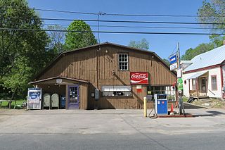
Northfield Falls is an unincorporated village in the town of Northfield, Washington County, Vermont, United States. The community is located along Vermont Route 12 1.5 miles (2.4 km) north of the village of Northfield and 7.1 miles (11.4 km) south-southwest of Montpelier. Northfield Falls has a post office with ZIP code 05664.
North Hyde Park is an unincorporated village in the town of Hyde Park, Lamoille County, Vermont, United States.
Bomoseen is an unincorporated village in the town of Castleton, Rutland County, Vermont, United States. The community is located along Vermont Route 30 on the eastern shore of Lake Bomoseen, 11.5 miles (18.5 km) west of Rutland. Bomoseen has a post office with ZIP code 05732.
Center Rutland is an unincorporated village in the town of Rutland, Rutland County, Vermont, United States. The community is located along U.S. Route 4 Business and Vermont Route 3 on the western border of the city of Rutland. Center Rutland had a post office from May 1, 1850, until March 19, 2011; it still has its own ZIP code, 05736.
Forest Dale is an unincorporated village in the town of Brandon, Rutland County, Vermont, United States. The community is located at the intersection of Vermont Route 53 and Vermont Route 73 15.5 miles (24.9 km) north of Rutland. Forest Dale has a post office with ZIP code 05745.
Gaysville is an unincorporated village in the town of Stockbridge, Windsor County, Vermont, United States. The community is located along Vermont Route 107 and the White River 18 miles (29 km) northeast of Rutland. Gaysville has a post office with ZIP code 05746.
Hydeville is an unincorporated village in the town of Castleton, Rutland County, Vermont, United States. The community is located along Vermont Route 4A 12.8 miles (20.6 km) west of Rutland. Hydeville has a post office with ZIP code 05750.
North Clarendon is an unincorporated village in the town of Clarendon, Rutland County, Vermont, United States. The community is located along U.S. Route 7 and the Cold River, 3 miles (4.8 km) south of Rutland. North Clarendon has a post office with ZIP code 05759.
East Charleston is an unincorporated village in the town of Charleston, Orleans County, Vermont, United States. The community is located along Vermont Route 105 12.6 miles (20.3 km) southeast of Newport. East Charleston has a post office with ZIP code 05833.
Lower Waterford is an unincorporated village in the town of Waterford, Caledonia County, Vermont, United States. The community is located along Vermont Route 18 7 miles (11 km) southeast of St. Johnsbury. Lower Waterford has a post office with ZIP code 05848, which opened on February 9, 1830.
North Concord is an unincorporated village in the town of Concord, Essex County, Vermont, United States. The community is located along U.S. Route 2 8.6 miles (13.8 km) east-northeast of St. Johnsbury. North Concord has a post office with ZIP code 05858.
Passumpsic is an unincorporated village in the town of Barnet, Caledonia County, Vermont, United States. The community is located along U.S. Route 5 and the Passumpsic River 3 miles (4.8 km) south of St. Johnsbury. Passumpsic has a post office with ZIP code 05861.
West Danville is an unincorporated village in the town of Danville, Caledonia County, Vermont, United States. The community is located at the intersection of U.S. Route 2 and Vermont Route 15 8.9 miles (14.3 km) west of St. Johnsbury. West Danville has a post office with ZIP code 05873.


