Brownington, Vermont

Last updated

Brownington, Vermont
Town
Oldstonehousemuseum.JPG
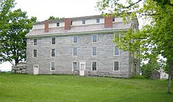
The Old Stone House Museum
Brownington vt highlight.png
Located in Orleans County, Vermont
Map of USA VT.svg
Location of Vermont with the U.S.A.
Coordinates: 44°49′32″N72°8′3″W / 44.82556°N 72.13417°W / 44.82556; -72.13417
Country United States
State Vermont
County Orleans
CharteredOctober 2, 1790
Settled1796
Organized1799
Area
  Total28.4 sq mi (73.6 km2)
  Land28.3 sq mi (73.3 km2)
  Water0.1 sq mi (0.4 km2)
Elevation
1,025 ft (342 m)
Population
 (2020)
  Total1,042
  Density37/sq mi (14.2/km2)
  Households
337
  Families
239
Time zone UTC-5 (EST)
  Summer (DST) UTC-4 (EDT)
ZIP code
05860
Area code 802
FIPS code 50-09850 [1]
GNIS feature ID1462056 [2]

Brownington is a town in Orleans County, Vermont, United States. The population was 1,042 as of the 2020 census. [3]

Contents

Geography

According to the United States Census Bureau, the town has a total area of 28.4 square miles (73.6 km2), of which 28.3 square miles (73.2 km2) is land and 0.1 square mile (0.4 km2) (0.49%) is water.

Brownington has three unincorporated villages: Brownington, Brownington Center, and Evansville.

The lie of the town is moderate but uneven. The central part of town is somewhat elevated. The Willoughby River flows through the southern part of town. Small streams are found throughout. Brownington Pond is in the north, partly in Derby.

The northeast part of town is delimited from its neighbor, the town of Charleston, by Chilafoux Road, which runs northwest-southeast, for about one-third of its length. [4]

Geology

Rocks are mostly of the calciferous mica schist, except in the southeastern part, where they are granite. A narrow vein of hornblende schist extends through the central part, from north to south. [5]

Local government

Town

In 2008, the town received its fire department services from the adjacent village of Orleans in the town of Barton. [10]

School District

The local school is part of the OSCU (Orleans Central Supervisory Union). The local school educates students K–8. Brownington pays the OCSU to educate grades 9–12 out of its budget at Lake Region Union High School (#24).

History

The town was named after the family Brown. Two chief grantees of Brownington were Daniel and Timothy Brown. There were six other male Browns and one woman, Sarah. [11]

Until 1816, court convened here, alternating with Craftsbury, both shire towns of the county. After that year, the legislature changed the county seat to Irasburg.

Alexander Twilight built Athenian Hall, [12] now called the Old Stone House [13] as a dormitory for a boarding academy in 1836. [14] It is a museum today. [15]

Part of the museum complex is the Samuel Read Hall House, located on the Hinman Settler Road. This Federal-style building was completed in 1831. For about twenty years it was the home of Hall, a pioneer in the field of American education. [16] [17]

The Orleans County Grammar School was moved back to its original location on August 8, 2016, by a team of 46 oxen. The school was built in 1823. [12]

Demographics

Historical population
CensusPop.Note
1800 65
1810 236263.1%
1820 26512.3%
1830 41255.5%
1840 48618.0%
1850 61326.1%
1860 76124.1%
1870 90118.4%
1880 854−5.2%
1890 799−6.4%
1900 748−6.4%
1910 7601.6%
1920 741−2.5%
1930 697−5.9%
1940 689−1.1%
1950 673−2.3%
1960 599−11.0%
1970 522−12.9%
1980 70835.6%
1990 705−0.4%
2000 88525.5%
2010 98811.6%
2020 1,0425.5%
U.S. Decennial Census [18]

As of the census [1] of 2000, there were 885 people, 337 households, and 239 families residing in the town. The population density was 31.3 people per square mile (12.1/km2). There were 450 housing units at an average density of 15.9 per square mile (6.1/km2). The racial makeup of the town was 97.06% White, 0.45% African American, 1.24% Native American, 0.23% Asian, 0.34% from other races, and 0.68% from two or more races. Hispanic or Latino of any race were 0.45% of the population.

There were 337 households, out of which 35.0% had children under the age of 18 living with them, 57.3% were married couples living together, 10.4% had a female householder with no husband present, and 28.8% were non-families. 21.4% of all households were made up of individuals, and 8.0% had someone living alone who was 65 years of age or older. The average household size was 2.63 and the average family size was 3.02.

In the town, the population was spread out, with 27.2% under the age of 18, 7.5% from 18 to 24, 28.8% from 25 to 44, 26.4% from 45 to 64, and 10.1% who were 65 years of age or older. The median age was 38 years. For every 100 females, there were 103.4 males. For every 100 females age 18 and over, there were 104.4 males.

The median income for a household in the town was $29,667, and the median income for a family was $37,721. Males had a median income of $26,210 versus $21,250 for females. The per capita income for the town was $14,004. About 10.8% of families and 17.9% of the population were below the poverty line, including 24.8% of those under age 18 and 25.3% of those age 65 or over.

Cultural events

Notable people

Related Research Articles

<span class="mw-page-title-main">Orleans County, Vermont</span> County in Vermont, United States

Orleans County is a county located in the northeastern part of the U.S. state of Vermont. As of the 2020 census, the population was 27,393. Its shire town is the city of Newport. The county was created in 1792 and organized in 1799. As in the rest of New England, few governmental powers have been granted to the county. The county is an expedient way of grouping and distributing state-controlled governmental services.

<span class="mw-page-title-main">Burke, Vermont</span> Town in Vermont, United States

Burke is a town in Caledonia County, Vermont, United States. The population was 1,651 at the 2020 census. The town contains the villages of East Burke, West Burke and Burke Hollow. The town is home to Burke Mountain and Burke Mountain Academy.

<span class="mw-page-title-main">Sheffield, Vermont</span> Town in Vermont, United States

Sheffield is a town in Caledonia County, Vermont, United States. The population was 682 at the 2020 census.

<span class="mw-page-title-main">Brighton, Vermont</span> Town in Vermont, United States

Brighton is a town in Essex County, Vermont, United States. The population was 1,157 at the 2020 census. The town was named "Gilead" in its original grant in 1780. The town was sold to a group consisting primarily of soldiers commanded by Colonel Joseph Nightingale and subsequently named "Random". The town's name was finally changed by the legislature to "Brighton" in 1832. The Brighton village of Island Pond gets its name from the Abenaki word Menanbawk, which literally means island pond.

<span class="mw-page-title-main">Wolcott, Vermont</span> Town in Vermont, United States

Wolcott is a town in Lamoille County, Vermont, United States. The town was named for General Oliver Wolcott, a signer of the Declaration of Independence. The population was 1,670 at the 2020 census.

<span class="mw-page-title-main">Charleston, Vermont</span> Town in Vermont, United States

Charleston is a town in Orleans County, Vermont, United States. The population was 1,021 at the 2020 census. The town contains two unincorporated villages: East Charleston and West Charleston.

<span class="mw-page-title-main">Coventry, Vermont</span> Town in Vermont, United States

Coventry is a town in Orleans County, Vermont, United States. The population was 1,100 at the 2020 census.

<span class="mw-page-title-main">Craftsbury, Vermont</span> Town in Vermont, United States

Craftsbury is a town in Orleans County, Vermont, United States. The population was 1,343 at the 2020 census. The town includes the unincorporated villages of Craftsbury, Craftsbury Common, Mill Village, and East Craftsbury.

<span class="mw-page-title-main">Derby, Vermont</span> Town in Vermont, United States

Derby is a town in Orleans County, Vermont, United States. The population was 4,579 at the 2020 census, making it the most populous community in Orleans County. The town contains four unincorporated villages: Beebe Plain, Clyde Pond, Lake Salem, and North Derby, and two incorporated villages: Derby Center and Derby Line.

<span class="mw-page-title-main">Glover, Vermont</span> Town in Vermont, United States

Glover is a town in Orleans County, Vermont, in the United States. As of the 2020 census, the town's population was 1,114. It contains two unincorporated villages, Glover and West Glover.

<span class="mw-page-title-main">Holland, Vermont</span> Town in Vermont, United States

Holland is a town in Orleans County, Vermont, United States. The population was 632 at the 2020 census.

<span class="mw-page-title-main">Jay, Vermont</span> Town in Vermont, United States

Jay is one of the northernmost towns in Orleans County, Vermont, United States, located on the Canada–US border. The population was 551 at the 2020 census. Jay is named for John Jay, one of the Founding Fathers of the United States. The US Census Bureau estimated that the town's population had increased by 13.1% between 2000 and 2005, the seventh largest increase in the state. Jay is also home to the Jay Challenge, a three-part stage-race, typically held in July.

<span class="mw-page-title-main">Lowell, Vermont</span> Town in Vermont, United States

Lowell is the westernmost town in Orleans County, Vermont, United States. The population was 887 at the 2020 census.

Orleans is a village in the northwestern corner of Barton, Orleans County, Vermont, United States. With a population of 788 at the 2020 census, it is the largest village in the county.

<span class="mw-page-title-main">Troy, Vermont</span> Town in Vermont, United States

Troy is a town in Orleans County, Vermont, United States. The population was 1,722 at the 2020 census. Troy contains two villages: the unincorporated village of Troy, and the incorporated village of North Troy.

<span class="mw-page-title-main">Westmore, Vermont</span> Town in Vermont, United States

Westmore is a town in Orleans County, Vermont, United States. The population was 357 at the 2020 census, making it the least populated and least densely populated town in the county. The town contains one unincorporated village clustered around Lake Willoughby.

<span class="mw-page-title-main">Albany, Vermont</span> Town in Vermont, United States

Albany is a town in Orleans County, Vermont, United States. The population was 976 at the 2020 census. Albany contains four villages: the incorporated village of Albany, and the unincorporated villages of Albany Center, East Albany and South Albany.

<span class="mw-page-title-main">Barton (village), Vermont</span> Village in Vermont, United States

Barton is a village located near the center of the town of Barton, in Orleans County, Vermont, United States. The population was 690 at the 2020 census.

<span class="mw-page-title-main">Barton, Vermont</span> Town in Vermont, United States

Barton is a town in Orleans County, Vermont, United States. The population was 2,872 at the 2020 census. The town includes two incorporated villages, Barton and Orleans. Approximately a quarter of the town's population lives in each of the villages, and approximately half lives outside the villages. Only four other towns in the state contain two incorporated villages.

<span class="mw-page-title-main">St. Johnsbury, Vermont</span> Town in Vermont, United States

St. Johnsbury is the shire town of Caledonia County, Vermont, United States. As of the 2020 census, the population was 7,364. St. Johnsbury is situated on the Passumpsic River and is located approximately six miles northwest of the Connecticut River and 48 miles (77 km) south of the Canada–U.S. border.

References

  1. 1 2 "U.S. Census website". United States Census Bureau . Retrieved January 31, 2008.
  2. "US Board on Geographic Names". United States Geological Survey. October 25, 2007. Retrieved January 31, 2008.
  3. "Census - Geography Profile: Brownington town, Orleans County, Vermont" . Retrieved December 28, 2021.
  4. "Northeast Kingdom Civil War Roundtable". Northeast Kingdom Civil War Roundtable: 2. July 2014.
  5. Child, Hamilton. (May 1887). Gazetteer of Lamoille and Orleans Counties, VT.; 1883-1884. Hamilton Child.
  6. "Select Board". Town of Brownington. Retrieved December 28, 2023.
  7. "Town of Brownington". Town of Brownington. Retrieved December 28, 2023.
  8. "Auditors". Town of Brownington. Retrieved December 28, 2023.
  9. "2022 Annual Town Report". Town of Brownington. The Memphremagog Press, Newport, VT. Retrieved December 28, 2023.
  10. Creaser, Richard (January 28, 2009). Water budget calls for higher rates. the Chronicle.
  11. Esther Munroe Swift. Vermont Place-Names: Footprints of History,Publisher: S. Greene Press (July 26, 1996) ISBN   0-8289-0291-7 ISBN   978-0828902915
  12. 1 2 "Heavy lifting: 46 oxen guide historic schoolhouse home". Burlington Free Press. August 8, 2016. Retrieved August 8, 2016.
  13. "Old Stone House Museum - Orleans County Historical Society". www.oldstonehousemuseum.org.
  14. "retrieved June 30, 2007". historicvermont.org.
  15. Discover the Barton Area. Barton Area Chamber of Commerce,undated, referenced February 2007
  16. Creaser, Richard (June 20, 2007). Up in flames is new exhibit at Old Stone House. the Chronicle.
  17. Times Argus: Kingdom Archived 2012-02-25 at the Wayback Machine , 26 July 2009
  18. "U.S. Decennial Census". United States Census Bureau. Retrieved June 19, 2015.
  19. Clan of the Hawk webpage Archived July 23, 2008, at the Wayback Machine
  20. Widwind.com retrieved August 4, 2007
  21. Essaff, Paul (2007). Northeast Kingdom of Vermont. Things To Do & Places to Go. Paul Essaff.
  22. Travel the Kingdom Archived December 24, 2007, at the Wayback Machine