Newport (city), Vermont

Last updated

Newport, Vermont
Newport VT 1.JPG
Newport from Lake Memphremagog
Indelgcityseal.png
Newport city vt highlight.png
Location in Vermont
Usa edcp location map.svg
Red pog.svg
Newport, Vermont
Location in the United States
Coordinates: 44°56′39″N72°12′16″W / 44.94417°N 72.20444°W / 44.94417; -72.20444
CountryUnited States
State Vermont
County Orleans
Organized1918
Government
  MayorVacant [1]
  City ManagerLaura Dolgin (R)
Area
[2]
  Total7.63 sq mi (19.76 km2)
  Land5.83 sq mi (15.09 km2)
  Water1.80 sq mi (4.67 km2)  20.87%
Elevation
722 ft (208 m)
Population
 (2020)
  Total4,455
  Density580/sq mi (230/km2)
Time zone UTC−5 (Eastern (EST))
  Summer (DST) UTC−4 (EDT)
ZIP code
05855
Area code 802
FIPS code 50-48850 [3]
GNIS feature ID1461773 [4]
Website www.newportvermont.org

Newport is the only city in, and the shire town [5] of, Orleans County, Vermont, United States. As of the 2020 Census, the population was 4,455. The city contains the second-largest population of any municipality in the county (only neighboring Derby is larger), and has the smallest geographic area. It is the second-smallest city by population in Vermont. Newport is also the name of neighboring Newport Town.

Contents

Newport was founded by European Americans as a settlement in 1793 and was first called Pickerel Point. It was the place where Rogers' Rangers retreated in 1759 after a French and Indian War incursion into Canada. In the 19th century, the village was stimulated by construction of the railroad in 1863, during the American Civil War. The lumbering firm Prouty & Miller operated here from 1865. Long after the post-war Reconstruction era, the village was the site for a Reunion Society of Vermont Officers in 1891. Newport has two public schools, one private school and a branch of the Community College of Vermont. As of the 2010 census there were 4,589 people.

History

Early

In 1753, during the French and Indian War, an Abenaki band took English captive John Stark by canoe down Lake Memphremagog and came ashore at the site where the city of Newport later developed. Allies of the French during this war, they had captured Stark in a raid. They held him until his family and community raised a ransom. They then returned him to his home in New Hampshire. Given the warfare on the border with Canada, both sides took captives for ransom beginning in the late 17th century. Business was brisk at the time of Queen Anne and other English rulers.

Newport as a settlement was founded in 1793, after the American Revolutionary War. [6] The village was first called Pickeral Point, but later renamed as Lake Bridge for its location at the head of Lake Memphremagog. [7]

In 1816, part of the former town of Salem was annexed to the Town of Newport; it was absorbed into what was then a village. [8]

The railroad was constructed to Newport in 1863. [9] In 1868, the Lake Bridge settlement was incorporated as the Village of Newport. It became a busy lumber town. The lumbering firm of Prouty & Miller was started in 1865. [10]

In 1932, during the Great Depression, the city operated a poor farm for the indigent, who worked for their board. [11]

Transportation

The Lady of the Lake steam excursion/ferry boat started operating in 1867. It stopped operations in 1917. This steamboat is used as Newport's logo.

In 1868, a livery stable started operating behind a hotel, several blocks from the railway station, which opened in 1863. At its peak, its owner kept 100 horses there. [12]

By the late 19th century, the Boston & Maine and Central Vermont railroads were routed through Lake Bridge. The small village expanded because of increased connections to outside markets and ease of transportation; it attracted more residents. By the late 20th century, railroad passenger traffic had declined because people relied on individual vehicles; the last passenger train left Newport in 1965. [13]

In 1917, the city paved Main Street. By the summer of 1930, traffic on the street had increased to 4,000 motor vehicles a day. [14]

The city sold its airport to the state of Vermont in the 1970s. [15]

Military

Rogers' Rangers, a Vermont militia, were forced to retreat through the county following their attack on Saint-Francis, Quebec in 1759, during the French and Indian War. To confound their pursuers, they split up on the east shore of Lake Memphremagog. One group followed the Clyde River east. Another followed the Barton River south. [16]

In the early 19th century, the women of pioneer Calvin Arnold's household refused to continue to live there. It was located near what is now Clyde Pond, and subject to raids by Indians. [17]

During the American Civil War, the city had a scare when they received news of the St. Albans Raid. They thought these raids might repeat throughout the state, particularly at the south end of the lake. The militia was turned out. The ferry from Magog was met with determined-looking armed men, much to the captain's surprise, who had heard nothing about the raid. Armed Norwich University students were shipped in by train. Nothing happened and everyone was sent home after a few days. [9]

In 1891, the American Civil War Reunion Society of Vermont Officers held its annual reunion in Newport. [18]

In August 1942, a single-engine Royal Canadian Air Force (RCAF) training plane crashed into the lake near the west shore and the city, killing the pilot, the only occupant. [19]

Architecture

Railroad station and steamboat Lady of the Lake in 1908 Railroad Station, Newport, VT.jpg
Railroad station and steamboat Lady of the Lake in 1908

In 1873, the Bellevue Hotel was built to accommodate 75; later it expanded to hold 100 guests. It was renamed as the Newport House by 1891. It was demolished in 1973. [20] The Memphremagog Hotel burned in 1907. [13]

The Newport Wharf Light was a tower built on Lake Memphremagog in 1879. It has since been demolished. [21]

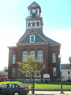
The current county courthouse was built in 1886. [14] That was the year that the legislature moved the shire town here. [22] In 1879, the Field Opera House and Clock Tower was constructed. In 1896, it was destroyed by fire. The municipal building was later constructed at this site. [23]

Lane's Opera House was constructed in 1892. It burned in 1923. [24]

A postcard image of Newport and Lake Memphremagog around 1910 Vermont, Newport and Lake Memphremagog.jpg
A postcard image of Newport and Lake Memphremagog around 1910

The Goodrich Memorial Library was built in 1899. [25] The parochial Sacred Heart School was opened in 1904 as part of the Burlington Roman Catholic Diocese School District. [26] It closed in the fall of 2007 because of falling enrollment.

Main Street in 1908 Main Street, Newport, VT.jpg
Main Street in 1908

In 1917, the city of Newport was formed from portions of the towns of Newport (former village of Newport) and Derby (former village of West Derby). It was organized on March 5, 1918. The four elementary schools were named after the section of the city they were in: East, West, and South schools. Newport High was across from the West School. There were 60 businesses downtown; east, west and south had an additional 40 businesses. [27]

The current federal courthouse was built in 1904. At the time, it included the United States post office, which has since relocated to a more modern facility. [14]

The city was once divided into at least five neighborhoods: Chief-O, Stove-Pipe City, Skunk Hollow, French Village, and Batesville. Most of these names are not used in the 21st century. Batesville was the section around Prouty Bay. Skunk Hollow was in the valley west of Western Avenue. [28]

Business

St. Mary Star of the Sea Catholic Church, completed 1877. Saint Mary's Catholic Church 191 Clermont Terrace Newport VA September 2017.jpg
St. Mary Star of the Sea Catholic Church, completed 1877.

The lumbering firm Prouty & Miller, started in 1865. It operated for more than 100 years, closing in the 1980s. [10]

The Frost Veneer Mill, located on Prouty Bay, was once a primary employer in the Batesville neighborhood. [28]

Between 1936 and 1953, the International Club in Newport had the largest dance floor in New England. 220 by 60 feet (67 by 18 m). [29] It could hold 2,000 dancers. Notable national performers entertained here while en route between the larger cities of Boston and Montreal, traveling on the Boston & Maine trains. They included: Louis Armstrong, Charlie Barnet, Les Brown, Cab Calloway, Rosemary Clooney, the Dorsey Brothers, Jimmy and Tommy; Stan Kenton, Kay Kyser, Gene Krupa, Glenn Miller, Tony Pastor, and Louis Prima. [30] [31]

In 2003, the Newport-headquartered Citizens Utility was sold. Its assets and operations were divided between Great Bay Hydro and Vermont Electric Cooperative. [17] The Vermont Teddy Bear Company once had a plant within the city. [32] A Columbia Forest Products plant employed about 100 workers. [33] A local subsidiary of an international ski clothing manufacturer once employed 30 workers. [34] It closed in 2011.

Geography

According to the United States Census Bureau, the city has a total area of 7.6 square miles (20 square kilometres), of which 6.0 square miles (16 km2) is land and 1.6 square miles (4.1 km2) (20.87%) is water. The city surrounds the southern shore of Lake Memphremagog. Three of the four major rivers in the county empty into the lake here: the Clyde, Barton, and the Black.

Newport borders the towns of Coventry to the south, Newport to the west, and Derby to the north and east.

Climate

Climate data for Newport, Vermont (1991–2020 normals, extremes 1930–present)
MonthJanFebMarAprMayJunJulAugSepOctNovDecYear
Record high °F (°C)64
(18)
68
(20)
83
(28)
87
(31)
94
(34)
95
(35)
98
(37)
95
(35)
96
(36)
84
(29)
75
(24)
66
(19)
98
(37)
Mean maximum °F (°C)46.8
(8.2)
50.4
(10.2)
59.2
(15.1)
76.1
(24.5)
84.7
(29.3)
89.1
(31.7)
89.5
(31.9)
88.4
(31.3)
84.9
(29.4)
75.1
(23.9)
63.7
(17.6)
51.1
(10.6)
90.0
(32.2)
Average high °F (°C)23.4
(−4.8)
27.1
(−2.7)
36.6
(2.6)
50.8
(10.4)
64.8
(18.2)
73.1
(22.8)
77.7
(25.4)
76.2
(24.6)
68.9
(20.5)
54.8
(12.7)
41.1
(5.1)
29.2
(−1.6)
52.0
(11.1)
Daily mean °F (°C)13.7
(−10.2)
16.0
(−8.9)
25.8
(−3.4)
40.0
(4.4)
53.3
(11.8)
62.3
(16.8)
67.2
(19.6)
65.3
(18.5)
57.8
(14.3)
45.2
(7.3)
33.2
(0.7)
21.3
(−5.9)
41.8
(5.4)
Average low °F (°C)3.9
(−15.6)
5.0
(−15.0)
14.9
(−9.5)
29.2
(−1.6)
41.9
(5.5)
51.6
(10.9)
56.6
(13.7)
54.5
(12.5)
46.8
(8.2)
35.6
(2.0)
25.3
(−3.7)
13.5
(−10.3)
31.6
(−0.2)
Mean minimum °F (°C)−19.6
(−28.7)
−15.1
(−26.2)
−8.7
(−22.6)
16.1
(−8.8)
28.8
(−1.8)
38.7
(3.7)
46.2
(7.9)
43.0
(6.1)
32.3
(0.2)
23.3
(−4.8)
8.3
(−13.2)
−9.0
(−22.8)
−21.9
(−29.9)
Record low °F (°C)−38
(−39)
−38
(−39)
−32
(−36)
−2
(−19)
20
(−7)
28
(−2)
36
(2)
32
(0)
23
(−5)
11
(−12)
−7
(−22)
−40
(−40)
−40
(−40)
Average precipitation inches (mm)2.83
(72)
2.44
(62)
2.83
(72)
3.34
(85)
3.94
(100)
4.52
(115)
4.54
(115)
4.42
(112)
3.93
(100)
4.29
(109)
3.35
(85)
3.40
(86)
43.83
(1,113)
Average snowfall inches (cm)21.5
(55)
20.2
(51)
18.4
(47)
4.5
(11)
0.0
(0.0)
0.0
(0.0)
0.0
(0.0)
0.0
(0.0)
0.0
(0.0)
0.8
(2.0)
7.0
(18)
25.2
(64)
98.6
(250)
Average extreme snow depth inches (cm)15.7
(40)
20.7
(53)
20.9
(53)
9.0
(23)
0.0
(0.0)
0.0
(0.0)
0.0
(0.0)
0.0
(0.0)
0.0
(0.0)
0.6
(1.5)
5.0
(13)
11.4
(29)
24.6
(62)
Average precipitation days (≥ 0.01 in)17.913.213.713.214.415.014.513.311.814.915.217.0174.1
Average snowy days (≥ 0.1 in)14.310.88.62.40.10.00.00.00.00.64.911.753.4
Source: NOAA [35] [36]

Demographics

Historical population
CensusPop.Note
1880 920
1890 1,73088.0%
1900 2,78761.1%
1910 3,65731.2%
1920 4,97636.1%
1930 5,0942.4%
1940 4,902−3.8%
1950 5,2176.4%
1960 5,019−3.8%
1970 4,664−7.1%
1980 4,7562.0%
1990 4,434−6.8%
2000 5,00512.9%
2010 4,589−8.3%
2020 4,455−2.9%
U.S. Decennial Census

From its founding, Newport's population plateaued around 5,000 people until 1950 when it started dropping. It reached bottom in 1990 at 4,434. In 2010 the population dropped from the 2000 census, and it still had not reached its 1950 high which was 5,217. As of the census [3] of 2010, there were 4,589 people, 2,086 households, and 1,191 families residing in the city. The population density was 830.0 people per square mile (320.5/km2). There were 2,342 housing units at an average density of 388.4 per square mile (150.0/km2). The racial makeup of the city was 96.14% White, 0.76% Black or African American, 0.62% Native American, 0.62% Asian, 0.22% from other races, and 1.64% from two or more races. Hispanic or Latino of any race were 1.28% of the population. Thirty-three percent were of French Canadian and French ancestry, 16% English, and 14% Irish.

There were 2,086 households, out of which 26.6% had children under the age of 18 living with them, 41.0% were married couples living together, 12.6% had a female householder with no husband present, and 42.9% were non-families. 35.5% of all households were made up of individuals, and 16.0% had someone living alone who was 65 years of age or older. The average household size was 2.20 and the average family size was 2.84.

In the city, the population was distributed by age with 22.2% under 18, 8.3% from 18 to 24, 27.1% from 25 to 44, 23.1% from 45 to 64, and 19.3% who were 65 years of age or older. The median age was 40 years. For every 100 females, there were 97.4 males. For every 100 females age 18 and over, there were 93.7 males.

In 2013, about 31% of adults in the area were obese. This was the highest in the state. [37]

Economy

Personal income

In 2017, the median income for a household in the city was $34,000. The median income for the state was $53,700. [38] The median income for a family was $34,922. Males had a median income of $33,810 versus $19,787 for females. The per capita income for the city was $20,054. About 13.0% of families and 18.2% of the population were below the poverty line, including 25.4% of those under age 18 and 5.4% of those age 65 or over.

The per capita income is the highest in Orleans County. The income ranks it 108 out of 282 census areas in Vermont.

Industry

Poulin Grain ships farm feed products to customers in New England and upstate New York. [39] It employs about 50 workers. The plant produces feed 24 hours a day, seven days a week. [40]

A Columbia Forest Products plant employs about 100 workers. [33]

A call center employs 120 people. [41] [42]

MSA manufactures military combat helmets. [43]

Health industry

North Country Hospital is the city's largest employer, employing 605 people. [44]

Orleans-Essex Visiting Nurses Association and Hospice employs 100 people locally.

Northeast Kingdom Human Services serves people with mental health needs.

Social services are provided in part by the Northeast Kingdom Community Action, located here and in other Northeast Kingdom sites.

Tourism

A commercial ice fishing derby has been held in February since 2004. In 2010, there were 920 participants. [45]

The only Soap Box Derby in Vermont is held in the city annually. The winner represents the state in the nationals. [46]

The local Rotary has held an annual music festival involving county high schools since 1947. [47]

Non-local government

Orleans County courthouse in Newport OrleansCountyCourtJail.JPG
Orleans County courthouse in Newport

The Northern State Correctional Facility, Newport Court, Reparative Services, and Vermont Correctional Industries are located in the city.

City government

Municipal offices are located in the former National Guard Armory, 222 Main Street, Newport.

Elected government consists of four aldermen with staggered two-year terms and a mayor. [48]

The city has a paid staff for tax assessment/zoning administrator, public works department, police, fire, recreation and parks, city attorney, and harbor master.

There are decision-making boards which are filled by unpaid appointees: planning commission (5 people, three-year terms), harbor commission (5 people, two-year terms), development review board (nine people, three-year terms), and a recreation committee.

There are normal officers for Vermont cities and sometimes towns, except they are appointed for cities: Delinquent tax collector, town service officer, animal control, health officer, tree warden, weigher of coal, inspector of wood and shingles, representative to NVDA (Northeastern Vermont Development Association) board, representative to EDC board (Vermont Economic Development Authority), and Fence Viewers.

Budget (proposed 2014–2015) – $2.99 million. About $1 million is for the police force. [49]

In 2017, the Grand List (total of taxable property) was $399 million. [50] About 25% of this is non-taxable, belonging to government and religious entities. [51]

Officials

The city is governed under the mayor-council system. In 2023, its mayor is Beth Barnes. The council is composed of Kevin Charboneau, John Wilson, Council President, Clark Curtis, Christopher Vachon. [52] The city clerk/treasurer is James D. Johnson, [53] and the city manager is Laura Dolgin. [54]

Former mayors

Elections

Fifty-four percent of those registered voted in the 2008 general election. This was the lowest turnout in the county. [55]

Education

Newport has two public schools: an elementary school, Newport City Elementary, and a high school, North Country Union High School. There is one private school, the United Christian Academy. In 1996 United Christian Academy was formed uniting Roman Catholic and Protestant churches in offering quality high school education. Elementary was later added following the closing of Sacred Heart School.

School districts

The city has a school board that governs the operation of Newport Elementary.

School Board directors include Leo Willey (chair), Corinna Lancaster (vice chair), Marcy Miller, Patrick Haugwitz, and Phil Laramie.

The budget for the Newport City Elementary School was $4,435,765 in 2007.

In addition, the city belongs to North Country Supervisory Union with members from nearby towns. They operate the North Country Union High School and the North Country Union Junior High School. The supervisor hired by this union board supervises the town school, as well as the union schools.

Higher education

Newport is home to a branch of the Community College of Vermont which enrolls nearly 300 students. [57] It awards an Associate's Degree for these undergraduate studies.

Infrastructure

Transportation

Major routes

U.S. Route 5 in Newport at the junction of Vermont Route 191 heading toward Interstate 91. US5-Newport.jpg
U.S. Route 5 in Newport at the junction of Vermont Route 191 heading toward Interstate 91.
  • US 5.svg U.S. Route 5 – connects the city with the town of Coventry to the south, and the town of Derby to the north and east
  • Vermont 14.svg VT Route 14 – connects the city with Coventry
  • Vermont 100.svg VT Route 100 – connects the city with the Town of Newport
  • Vermont 105.svg VT Route 105 – connects the city with the Town of Newport (concurrent with route 100), and the town of Derby (concurrent with route 5)
  • Vermont 191.svg 
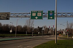
VT Route 191 – "Access Road", connects I-91, Exit 27, to the city of Newport

U.S. Route 5 and VT Route 105 are concurrent through much of their routes through the city.

Interstate 91 is the nearest interstate highway, and runs through the neighboring town of Derby. Two exits (for VT Route 191 and for US 5/VT 105) provide access to Newport.

The city has six stoplights, which is most of the stoplights in the county. Five are on Route 5.

Major bridges

There are three major bridges over the South Bay of Lake Memphremagog, two of which connect two parts of the city, the former village of Newport with the former village of West Derby. Those two are the bridge on Route 5, and the "Long Bridge" connecting Route 5 to Mt. Vernon Street. Plans are underway to replace this latter bridge starting in 2012. It will cost about $5.26 million. The state will pay 90%; the city, the remainder. [58]

The final bridge is the trestle for the railway.

Local community public and private transportation

RCT (Rural Community Transportation), a non-profit organization, runs out of Saint Johnsbury and services Caledonia, Essex, and Orleans counties. [56] For general use, there are four buses north and south during the week from west Newport city to Derby, and two buses each way on Saturday. The fare is 25 cents. [59]

Railroads

The city was once a junction for the Boston & Maine Railroad's Alouette and Red Wing trains splitting northwest to Montreal on the Canadian Pacific Railway and other Red Wing sections joining the New Haven Railroad's Connecticut Yankee and going directly north on Quebec Central Railway tracks to Sherbrooke, Quebec and Quebec City. Trains went south on Boston and Maine tracks towards New York City and on B&M tracks also towards Boston via Concord, New Hampshire. The Connecticut Yankee was the last strictly north–south international train, and it stopped going north across the border in the mid-1950s.

Washington County Railroad (known by the reporting mark WACR) – In 2007 WACR was awarded a 30-year contract by the State of Vermont to operate the rail line between White River Junction and Newport. Today the only regular service on this line is freight traffic.

Canadian Pacific Kansas City (known by the reporting mark CPKC) – CPKC operates the line running northwest through North Troy and eventually on to Farnham, Quebec. It interchanges freight traffic with the WACR at Newport yard, just south of town.

The Massawippi Valley Railway line, which was part of the Quebec Central Railway, once ran east of Lake Memphremagog up to Lennoxville, Quebec, but it has been abandoned and the right-of-way has been converted into a mixed-use bicycle and walking path.

Airport

The city is served by the Northeast Kingdom International Airport. [60] It contains two runways of 4,000 feet (1,200 m) each 05–23, and 18–36.

Sewage

The city discharged an average of 908,917 US gallons (3,440,630 L; 756,832 imp gal) of treated wastewater daily into the Clyde River in 2003–2004. [61]

Media

Notable people

Related Research Articles

<span class="mw-page-title-main">Orleans County, Vermont</span> County in Vermont, United States

Orleans County is a county located in the northeastern part of the U.S. state of Vermont. As of the 2020 census, the population was 27,393. Its shire town is the city of Newport. The county was created in 1792 and organized in 1799. As in the rest of New England, few governmental powers have been granted to the county. The county is an expedient way of grouping and distributing state-controlled governmental services.

<span class="mw-page-title-main">Brighton, Vermont</span> Town in Vermont, United States

Brighton is a town in Essex County, Vermont, United States. The population was 1,157 at the 2020 census. The town was named "Gilead" in its original grant in 1780. The town was sold to a group consisting primarily of soldiers commanded by Colonel Joseph Nightingale and subsequently named "Random". The town's name was finally changed by the legislature to "Brighton" in 1832. The Brighton village of Island Pond gets its name from the Abenaki word Menanbawk, which literally means island pond.

<span class="mw-page-title-main">Island Pond, Vermont</span> Census-designated place in Vermont, United States

Island Pond is a census-designated place (CDP) in the town of Brighton in Essex County, Vermont, United States. The population was 750 at the 2020 census. It is part of the Berlin, NH–VT Micropolitan Statistical Area.

<span class="mw-page-title-main">Coventry, Vermont</span> Town in Vermont, United States

Coventry is a town in Orleans County, Vermont, United States. The population was 1,100 at the 2020 census.

<span class="mw-page-title-main">Derby, Vermont</span> Town in Vermont, United States

Derby is a town in Orleans County, Vermont, United States. The population was 4,579 at the 2020 census, making it the most populous community in Orleans County. The town contains four unincorporated villages: Beebe Plain, Clyde Pond, Lake Salem, and North Derby, and two incorporated villages: Derby Center and Derby Line.

Orleans is a village in the northwestern corner of Barton, Orleans County, Vermont, United States. With a population of 788 at the 2020 census, it is the largest village in the county.

<span class="mw-page-title-main">Stanstead, Quebec</span> Border town in southern Quebec

Stanstead is a town in the Memphrémagog Regional County Municipality in the Estrie region of Quebec, located on the Canada–United States border across from Derby Line, Vermont.

<span class="mw-page-title-main">Barton, Vermont</span> Town in Vermont, United States

Barton is a town in Orleans County, Vermont, United States. The population was 2,872 at the 2020 census. The town includes two incorporated villages, Barton and Orleans. Approximately a quarter of the town's population lives in each of the villages, and approximately half lives outside the villages. Only four other towns in the state contain two incorporated villages.

<span class="mw-page-title-main">Newport (town), Vermont</span> Town in Vermont, United States

Newport is a town in Orleans County, Vermont, United States. The population was 1,526 at the 2020 census. The town is referred to by the United States Postal Service and the media as Newport Center, the name of the main settlement of the town. Newport is also the name of neighboring Newport City.

The Northeast Kingdom is the northeast corner of the U.S. state of Vermont, approximately comprising Essex, Orleans and Caledonia counties and having a population at the 2010 census of 64,764. The term "Northeast Kingdom" is attributed to George D. Aiken, former Governor of Vermont and a U.S. senator, who first used the term in a 1949 speech.

<span class="mw-page-title-main">Beebe Plain, Vermont</span> US portion of the internationally-divided, unincorporated village of Beebe Plain

Beebe Plain is an unincorporated community in the town of Derby in Orleans County, Vermont, United States, which extends into the municipality of Stanstead, Quebec, Canada. The village is divided by the Canada–United States border between Canada and the United States; the Canadian portion of Beebe Plain had the status of an incorporated municipality in its own right until 1995.

<span class="mw-page-title-main">Vermont Route 105</span> State highway in Vermont, United States

Vermont Route 105 (VT 105) is a 98.135-mile-long (157.933 km) state highway located in northern Vermont in the United States. The route runs from U.S. Route 7 (US 7) in St. Albans in the west to the New Hampshire state line in Bloomfield in the east. The road continues across the state line as Bridge Street, a short unnumbered New Hampshire state route to US 3 in North Stratford, New Hampshire. As it is not a New Hampshire state highway, the connection is signed with Vermont state highway signage, similar to how connections to Vermont state routes are indicated elsewhere in New Hampshire.

<span class="mw-page-title-main">Lake Memphremagog</span> Lake on the border of Vermont and Quebec

Lake Memphremagog is a fresh water glacial lake located between Newport, Vermont, United States and Magog, Quebec, Canada. The lake spans both Quebec and Vermont, but is mostly in Quebec. Most of the watershed that feeds the lake is located in Vermont, and is a source for accumulated phosphorus, sediments, and other pollutants. Cleanup efforts since the late 1980s have improved the water quality. The lake furnishes potable water for 200,000 people.

<span class="mw-page-title-main">Vermont Route 16</span> State highway in northern Vermont, US

Vermont Route 16 (VT 16) is a 27.890-mile-long (44.885 km) state highway in northern Vermont, United States. It begins at VT 15 in Hardwick and heads northward to U.S. Route 5 (US 5) in Barton. From Barton, it heads eastward to VT 5A in Westmore. The portion of VT 16 east of US 5 is town-maintained and signed east–west. The remainder of the route is signed north–south.

<span class="mw-page-title-main">Lake Willoughby</span> Glacial lake (ice age) in Vermont, U.S.

Lake Willoughby is a lake in the town of Westmore in Orleans County in the Northeast Kingdom of Vermont, United States.

<span class="mw-page-title-main">Barton River (Vermont)</span> River in Vermont

The Barton River is a tributary of Lake Memphremagog, over 22 miles (35 km) long, in northern Vermont in the United States.

The Clyde River is a tributary of Lake Memphremagog, over 33.5 miles (54 km) long, in northern Vermont in the United States. It is the easternmost of the four major rivers in Orleans County. It is the most powerful of the four within Orleans County, powering several turbines at damsites. It is part of the Northern Forest Canoe Trail.

<span class="mw-page-title-main">U.S. Route 5 in Vermont</span>

U.S. Route 5 (US 5) is a part of the United States Numbered Highway System that runs from New Haven, Connecticut, to the Canada–United States border at Derby Line, Vermont. In Vermont, the road runs south–north from the Massachusetts state line near Guilford to the international border. The 192.317 miles (309.504 km) that lie in Vermont are maintained by the Vermont Agency of Transportation (VTrans) and run largely parallel to Interstate 91 (I-91). US 5 also follows the path of the Connecticut River from the Massachusetts border to St. Johnsbury, where the river turns northeast while US 5 continues north. The highway serves the major towns of Brattleboro, Hartford, and St. Johnsbury, along with the city of Newport near the Canadian border.

North Country Hospital is a Critical Access Hospital in Newport City, Vermont.

<span class="mw-page-title-main">Newport Downtown Historic District (Newport, Vermont)</span> Historic district in Vermont, United States

The Newport Downtown Historic District encompasses most of the historic downtown area of the city of Newport, Vermont. The city developed as a transit hub and tourist area in the second half of the 19th century, spurred by the construction of a railroad to the area. The district, roughly bounded by Third Street, Coventry Street, and Lake Memphremagog, was listed on the National Register of Historic Places in 2006.

References

  1. Boronski, Tyler (May 24, 2023). "Newport, VT mayor resigns, cites bullying, intimidation from city council". WPTZ. Retrieved May 25, 2023.
  2. "2019 U.S. Gazetteer Files". United States Census Bureau. Retrieved August 7, 2020.
  3. 1 2 "U.S. Census website". United States Census Bureau . Retrieved January 31, 2008.
  4. "US Board on Geographic Names". United States Geological Survey. October 25, 2007. Retrieved January 31, 2008.
  5. Title 24, Part I, Chapter 1, §11, Vermont Statutes. Accessed 2021-11-01.
  6. Columbia-Lippincott Gazetteer. (New York: Columbia University Press, 1952) p. 1314
  7. Austin J. Coolidge & John B. Mansfield, A History and Description of New England; Boston, Massachusetts 1859
  8. "Derby, Vermont, New England, USA". Virtualvermont.com. May 25, 2013. Archived from the original on January 5, 2013. Retrieved January 19, 2014.
  9. 1 2 Robinson, C. D. (June 2010). "The Memphremagog House and ST. Albans Raid". Newport Express and Standard, 1929. Newport, Vermont: Northland Journal. p. 10.
  10. 1 2 Vermont Almanac accessed March 2, 2008
  11. Wheeler, Scott (May 2012). "Life Down on the Community Poor Farm - Part 2". Derby, Vermont: Northland Journal. p. 27.
  12. Gibson, Peggy Day (August 6, 2008). The Voice of Harness Racing. the Chronicle.
  13. 1 2 Wheeler, Scott (January 2009). "Boxing, Singing, and Riding the Rails into the Page of Newport's History". Vermont's Northland Journal. 7 (10): 10.
  14. 1 2 3 Historic marker #9, Newport, Vermont
  15. Wright, Duane (September 2009). "Up, Up and Away with Cecil Wright and His Flying Machines". Vermont's Northland Journal. 8 (6): 8.
  16. Darrell Hoyt (1985). Sketches of Orleans, Vermont. Mempremagog Press. ISBN   0-9610860-2-5., page 1
  17. 1 2 Wheeler, Scott (February 2008). The Man Who Helped Electrify the Jay Peak Ski Lift. Northland Journal.
  18. Huguenin, Joan (July 18, 2018). "Reunion Society of Vermont Officers". Northeast Kingdom Civil War Round Table: 9.
  19. "Salvage Operations on Crashed Plane Now Underway". Derby, Vermont. September 2008. pp. 29–30. November 13, 1943 Newport Daily Express, as quoted in the Northland Journal
  20. Nelson, Emily M. (December 2009). "The History of the Newport House". Vermont's Northland Journal. 8 (9): 8, 9.
  21. Lighthouses at Lighthouse Depot ... Lighthouse Explorer Database ... Newport Wharf Light Archived 2007-09-27 at the Wayback Machine
  22. Young, Darlene (1998). A history of Barton Vermont. Crystal Lake Falls Historical Association.
  23. Malloy, Barbara (November 11, 2013). "unk". The Newport Daily Express. Newport, Vermont.
  24. "The Lane Opera House / Le " Lane Opera House " Historical Marker". www.hmdb.org. Retrieved April 17, 2019.
  25. Goodrich Memorial Library website Archived 2012-10-29 at the Wayback Machine
  26. [ dead link ]
  27. McNeal, Brian D. (December 16, 2015). "Remembering a Newport that was". The Chronicle. Barton, Vermont. pp. 4A.
  28. 1 2 Bessette, Norman (October 24, 2018). "Remembering Batesville". The Chronicle. Barton, Vermont. pp. 1B.
  29. "Archived copy" (PDF). Archived from the original (PDF) on September 27, 2011. Retrieved April 17, 2011.{{cite web}}: CS1 maint: archived copy as title (link)
  30. Old Stone House Museum (June 29, 2007). Big band dance to honor Korean War veterans. the Chronicle.
  31. Goyette, Ray (August 2006). Reader Reflects on the International Club. Vermont's Northland Journal.
  32. Career Opportunities Archived 2007-02-21 at the Wayback Machine
  33. 1 2 The Associated Press (December 4, 2008). 54 workers laid off in Newport. Burlington Free Press.
  34. "Bogner Of America Williston VT, –". Manta.com. Retrieved January 19, 2014.
  35. "NowData – NOAA Online Weather Data". National Oceanic and Atmospheric Administration. Retrieved May 18, 2021.
  36. "Station: Newport, VT". U.S. Climate Normals 2020: U.S. Monthly Climate Normals (1991-2020). National Oceanic and Atmospheric Administration. Retrieved May 18, 2021.
  37. Starr, Tena (September 18, 2013). "Three-fourths of region's adults are overweight". The Chronicle. Barton, Vermont. pp. 1A.
  38. Gresser, Joseph (August 30, 2017). "A plan for reviving downtown Newport". The Chronicle. Barton, pp} 0. pp. 1A, 22A, 23A.{{cite news}}: CS1 maint: location (link)
  39. Poulin Grain - Dealer Locator
  40. Vermont Business Magazine Archived 2006-11-22 at the Wayback Machine
  41. "Manta - Crmi Solutions, Inc". www.manta.com. Archived from the original on March 31, 2009.
  42. the Chronicle, September 3, 2008, page 11, "We're on a real growth path right now"
  43. [ dead link ]
  44. North Country Hospital information Archived 2011-04-26 at the Wayback Machine
  45. Creaser, Richard (February 2, 2011). "Northeast Kingdom's lakes ripe for ice fishing". The Chronicle . Barton, Vermont. p. 12.
  46. The Chronicle, July 1, 2009, page 21, "Mosholder takes top spot in derby," Dr. Turcotte
  47. "Rotary holds sixty-ninth annual music festival". the Chronicle. Barton, Vermont. April 10, 2013. p. 3.
  48. Newport, Vermont Archived 2007-07-07 at the Wayback Machine
  49. Gresser, Joseph (January 15, 2014). "Aldermen reluctantly approve budget". The Chronicle. Barton, Vermont. pp. 1A, 25A.
  50. Gresser, Joseph (June 21, 2017). "Reappraisal could lead to drop in tax rate". The Chronicle. Barton, Vermont. pp. 1A. Retrieved July 12, 2017.
  51. Gresser, Joseph (September 13, 2017). "Tax rate set, water issues discussed". The Chronicle. Barton, Vermont. pp. 12A, 13A.
  52. Newport City Council Archived 2009-07-18 at the Wayback Machine , Newport, 2015. Accessed 2015-04-25.
  53. City Clerk/Treasurer Archived 2009-07-18 at the Wayback Machine , Newport, 2008. Accessed 2015-4-25.
  54. City Manager Archived 2009-07-18 at the Wayback Machine , Newport, 2015. Accessed 2015-04-25.
  55. Voter turnout. the Chronicle. November 5, 2008.
  56. 1 2 Annual City & School Report, City of Newport, Vermont. Memphremagog Press, Inc., Newport, Vermont. 2007.
  57. "Learn About CCV - Community College of Vermont". ccv.edu. Retrieved April 17, 2019.
  58. Gresser, Joseph (July 21, 2010). "Long Bridge to close for long time". Barton, Vermont: the Chronicle. p. 8.
  59. Rural Community Transportation Large Format Bus Schedule - The Highlander (Newport/Derby/Derby Line). 2008.
  60. "Newport (Vermont) State Airport (EFK)". Vimeo. Retrieved April 17, 2019.
  61. "Basin 17:Lake Memphremagog Watershed Assessment Report". Vermont Agency of Natural Resources,Department of Environmental Conservation, Water Quality Division. March 2006. p. 34. Archived from the original (PDF) on August 29, 2007.
  62. "Newport Dispatch". Archived from the original on March 30, 2019. Retrieved February 2, 2020.
  63. Proceedings of the Vermont Historical Society. Montpelier, VT: Vermont Historical Society. 1923. p. 270.
  64. "Gen. Buzzell Dead at 64". Bennington Evening Banner . Bennington, VT. January 23, 1959. p. 1 via Newspapers.com.
  65. Romig, Walter (1947). The American Catholic Who's Who. Vol. 7. Grosse Point, MI: Walter Romig. p. 65.
  66. "Obituary, Rudolph J. Daley" . Burlington Free Press . Burlington, VT. September 27, 1990. pp. 2B, 9B via Newspapers.com.
  67. "Hon. William Weston" . The Express and Standard. Newport, VT. March 30, 1875. p. 3 via Newspapers.com.

Further reading