Rutland County, Vermont

Last updated

Rutland County
RutlandVT CourthouseAndBaptistChurch.jpg
Map of Vermont highlighting Rutland County.svg
Location within the U.S. state of Vermont
Vermont in United States.svg
Vermont's location within the U.S.
Coordinates: 43°34′48″N73°02′12″W / 43.58009°N 73.03661°W / 43.58009; -73.03661
CountryFlag of the United States.svg United States
StateFlag of Vermont.svg  Vermont
Founded1781
Named for Rutland, Massachusetts
Shire Town Rutland
Largest city Rutland
Area
  Total945 sq mi (2,450 km2)
  Land930 sq mi (2,400 km2)
  Water15 sq mi (40 km2)  1.6%
Population
 (2020)
  Total60,572
  Estimate 
(2022)
60,366 Decrease2.svg
  Density64/sq mi (25/km2)
Time zone UTC−5 (Eastern)
  Summer (DST) UTC−4 (EDT)
Congressional district At-large

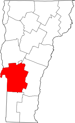
Rutland County is a county located in the U.S. state of Vermont. As of the 2020 census, the population was 60,572, [1] making it the second-most populous county in Vermont. Its county seat and most populous municipality is the city of Rutland. [2]

Contents

History

Castleton University is located in Castleton, Vermont within Rutland County Castleton state college Woodruff Hall.jpg
Castleton University is located in Castleton, Vermont within Rutland County

During the Revolutionary War there were a number of forts and roads that went through the area now known as Rutland County. In Castleton there was Fort Warren and a possible fort at Hydeville. In Pittsford there was Fort Vengeance and Fort Mott. And in Rutland there was Fort Ranger. The Hubbardton Military Road was a road built in 1775 for the American Revolution that went through the modern day towns of Benson, Hubbardton and Castleton. [3] The Crown Point Road (which was built in 1759 and used until 1783) goes through the modern day towns of Whiting, Sudbury, Hubbardton, Castleton, Ira, Rutland, Clarendon, Shrewsbury, Wallingford and Mount Holly and extended all the way to Fort at Number 4, Charlestown, New Hampshire. [4]

On February 16, 1781, Rutland County was created from Bennington County. [5] From June 26, 1781, until February 23, 1782, Vermont attempted to annex part of New York east of the Hudson River (the so-called West Union); inhabitants in the area favored Vermont's township form of government, while Vermont hoped to gain bargaining power through expansion. [6] New York did not lose control of the area. For almost seven months Rutland County included part of Charlotte County (now Washington County), New York. [7]

In February 1783 Orange County gained the towns of Brookfield [8] and Randolph [9] and Windsor County gained the towns of Bethel [10] and Rochester [11] from Rutland. On October 18, 1785 Addison County was created from Rutland. [12]

On February 27, 1787, Windsor County gained the town of Stockbridge from Rutland, [13] then on October 31, 1792, Rutland gained from Windsor County when the town of Mount Holly was created from Jackson's Gore and the towns of Ludlow and Wallingford. [14] Windsor County gained Benton's Gore from Rutland on March 2, 1797. [15]

On October 25, 1805, Rutland County gained from Bennington County when the town of Mount Tabor gained from the town of Peru. [16] On October 29, 1806, Windsor County gained from Rutland County when the town of Rochester gained a small area from the town of Pittsfield. [17] On November 15, 1813, the county gained from Windsor County when the town of Pittsfield gained a small area from the town of Stockbridge, a change too small to appear on maps. [18] On November 9, 1814 Addison County gained from Rutland County when the town of Goshen gained from the town of Philadelphia. [19] On October 22, 1822, the county gained from Windsor County when the town of Pittsfield gained a small area from the town of Stockbridge. [20] On November 3, 1823, it gained from Windsor County again when the town of Shrewsbury gained a small area from the town of Plymouth. [21] On November 15, 1824, Windsor County gained from Rutland County when the town of Rochester gained a small area from the town of Pittsfield. [22] On November 17, 1825, Bennington County gained from the county when the town of Dorset gained a small area from the town of Mount Tabor. [23]

On November 7, 1839, the Legislature authorized Addison County to gain a small area from Rutland County when the town of Whiting was to gain from the town of Orwell. But there is no evidence that a change took effect. [24] Addison County gained the town of Orwell from Rutland County on December 1, 1847. [25] On March 6, 1855, Addison County gained another small area from the county when the town of Goshen gained "Clemens Land" from the town of Brandon. [26]

On November 10, 1870, the Legislature authorized Rutland County to gain a small area from Windsor County when the town of Mount Holly was to gain from the town of Weston. But there is no evidence that the change took effect. [27] On April 7, 1880, the county lost to Washington County, New York, when New York gained a small area west of the village of Fair Haven from Vermont due to a change in the course of the Poultney River, a change too small to see on most maps. [28] On November 21, 1884, Windsor County gained a small area from Rutland County when the town of Stockbridge gained Parker's Gore. [29] On October 8, 1895, Windsor County gained from the county when the town of Weston gained from the town of Mount Tabor. [30]

The county experienced the first outbreak of polio in the United States in 1894. Within weeks, 132 persons, mostly children, were paralyzed. An additional 18 had died. [31]

Geography

According to the United States Census Bureau, the county has a total area of 945 square miles (2,450 km2), of which 930 square miles (2,400 km2) is land and 15 square miles (39 km2) (1.6%) is water. [32] It is the second-largest county in Vermont by area. The primary stream of the county is Otter Creek, which runs through the county from the south to the north.

Adjacent counties

National protected areas

Demographics

Historical population
CensusPop.Note
1790 15,590
1800 23,81352.7%
1810 29,48623.8%
1820 29,9831.7%
1830 31,2944.4%
1840 30,699−1.9%
1850 33,0597.7%
1860 35,9468.7%
1870 40,65113.1%
1880 41,8292.9%
1890 45,3978.5%
1900 44,209−2.6%
1910 48,1398.9%
1920 46,213−4.0%
1930 48,4534.8%
1940 45,638−5.8%
1950 45,9050.6%
1960 46,7191.8%
1970 52,63712.7%
1980 58,34710.8%
1990 62,1426.5%
2000 63,4002.0%
2010 61,642−2.8%
2020 60,572−1.7%
2022 (est.)60,366 [33] −0.3%
U.S. Decennial Census [34]
1790–1960 [35] 1900–1990 [36]
1990–2000 [37] 2010–2020 [1]

2010 census

As of the census of 2010, there were 61,642 people, 25,984 households, and 16,018 families residing in the county. [38] The population density was 66.3 inhabitants per square mile (25.6/km2). There were 33,768 housing units at an average density of 36.3 per square mile (14.0/km2). [39] The racial makeup of the county was 97.1% white, 0.6% Asian, 0.5% black or African American, 0.2% American Indian, 0.2% from other races, and 1.3% from two or more races. Those of Hispanic or Latino origin made up 1.1% of the population. [38]

Of the 25,984 households, 25.9% had children under the age of 18 living with them, 47.3% were married couples living together, 9.9% had a female householder with no husband present, 38.4% were non-families, and 30.2% of all households were made up of individuals. The average household size was 2.28 and the average family size was 2.81. The median age was 44.3 years. [38]

The median income for a household in the county was $47,027 and the median income for a family was $58,790. Males had a median income of $40,638 versus $34,580 for females. The per capita income for the county was $25,426. About 8.1% of families and 11.8% of the population were below the poverty line, including 15.2% of those under age 18 and 8.5% of those age 65 or over. [40]

Politics

In 1828, Rutland County was won by National Republican Party candidate John Quincy Adams and by Henry Clay in 1832.

From William Henry Harrison in 1836 to Winfield Scott in 1852, the county would be won by Whig Party candidates.

From John C. Frémont in 1856 to Richard Nixon in 1960, the Republican Party would have a 104-year winning streak in the county.

In 1964, Rutland County was won by Democratic Party incumbent President Lyndon B. Johnson, who became the first Democratic presidential candidate to not only win the county, but to win the state of Vermont entirely.

Following the Democrats' victory in 1964, the county went back to voting for Republican candidates for another 20 year winning streak starting with Richard Nixon in 1968 and ending with George H. W. Bush in 1988, who became the last Republican presidential candidate to win the county.

In 1992, the county was won by Bill Clinton and has been won by Democratic candidates ever since. That said, Rutland County has continued to be relatively close in some presidential elections. In 2000, Al Gore carried Rutland County by just 1.6%; in 2004, Kerry carried it by 4.7%; and in 2016, Hillary Clinton carried it by 3.9% (with a substantial 'other' vote in the 2000 and 2016 elections).

Republicans see greater success at a local level in Rutland County. A majority of the county's legislative seats in both the Vermont House of Representatives and Vermont Senate are held by Republicans. In nine of the ten past gubernatorial elections, the Republican candidate has won the greatest number of votes in Rutland County. Most recently, incumbent Republican governor Phil Scott won 74 percent of Rutland County's votes in the 2020 Vermont gubernatorial election.

United States presidential election results for Rutland County, Vermont [41] [42]
Year Republican Democratic Third party
No.%No.%No.%
2020 14,67243.19%18,23053.66%1,0683.14%
2016 12,47942.14%13,63546.04%3,50111.82%
2012 10,83537.87%17,08859.73%6862.40%
2008 11,58436.64%19,35561.22%6782.14%
2004 14,44046.62%15,90451.34%6312.04%
2000 13,54646.13%13,99047.65%1,8266.22%
1996 9,93436.48%13,23048.59%4,06514.93%
1992 10,96335.20%12,82941.19%7,35223.61%
1988 14,48255.15%11,49643.78%2831.08%
1984 15,23660.98%9,54538.20%2040.82%
1980 11,14245.98%9,59639.60%3,49614.43%
1976 11,56553.00%9,86845.23%3861.77%
1972 14,14362.68%8,26136.61%1590.70%
1968 10,31851.26%9,00044.72%8094.02%
1964 7,16535.11%13,24164.89%00.00%
1960 12,16656.82%9,24643.18%00.00%
1956 14,57073.83%5,16526.17%00.00%
1952 13,98069.95%5,97029.87%360.18%
1948 10,20660.56%6,45238.28%1951.16%
1944 9,54457.30%7,11142.70%00.00%
1940 10,82955.02%8,79844.70%540.27%
1936 10,79452.94%9,54346.80%540.26%
1932 10,82154.24%8,92444.73%2061.03%
1928 12,62159.36%8,60940.49%320.15%
1924 10,64274.32%2,47717.30%1,2018.39%
1920 8,94073.10%3,19226.10%970.79%
1916 5,92666.35%2,78531.18%2212.47%
1912 2,99936.03%2,07924.98%3,24639.00%
1908 5,64375.70%1,54220.69%2693.61%
1904 5,77277.12%1,36718.27%3454.61%
1900 5,90174.66%1,87423.71%1291.63%
1896 6,79478.00%1,66119.07%2552.93%
1892 5,21066.50%2,42630.96%1992.54%
1888 6,08868.57%2,41727.22%3734.20%
1884 5,09666.68%2,25329.48%2943.85%
1880 5,69069.79%2,42129.69%420.52%

Transportation

Air

The Rutland–Southern Vermont Regional Airport is located just south of Rutland city in North Clarendon. It is a commercial airport providing three flights daily to Boston.

Rail

Passenger rail service is provided by Amtrak via the Ethan Allen Express which connects Rutland with Burlington and New York City. There are two train stations in Rutland County served by this route: Castleton station and Rutland station.

Bus

"The Bus" in Rutland city The Bus Rutland.jpg
"The Bus" in Rutland city

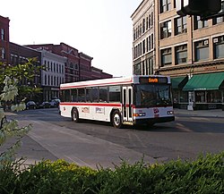
The Marble Valley Regional Transit District provides "The Bus" with service to the city of Rutland and the towns of Rutland, West Rutland, Castleton, Fair Haven, Poultney, Proctor, and Killington, as well as commuter service to Ludlow, Middlebury and Manchester.

Premier Coach's Vermont Translines serves Rutland daily with two intercity bus connections between Burlington, Lebanon, New Hampshire and Albany, New York in a partnership with Greyhound. [43] They also serve Wallingford, Brandon, Mendon and Killington along the two routes.

Highway

Communities

City

Towns

Incorporated village

Census-designated places

Other communities

Education

School districts in the county include: [44]

K-12:

Elementary:

See also

Footnotes

  1. 1 2 "State & County QuickFacts". United States Census Bureau. Retrieved August 16, 2023.
  2. "Find a County". National Association of Counties. Retrieved June 7, 2011.
  3. Wheeler, Joseph (1968). The Mount Independence 1776 Military Road (1st ed.). Benson, Vermont: J. L. Wheeler. pp. 94–95.
  4. undefined, undefined. "Crown Point Military Road". Houfy. Retrieved February 25, 2023.
  5. Vermont State Papers, 13:5-6.
  6. Vt. State Papers, 13:45-46; Newton, 83-87; Williamson, C., 101-102.
  7. Vt. State Papers, 3, pt. 2: 67-68.
  8. Vt. State Papers, 13:174.
  9. Vt. Laws 1783 in Vt. State Papers, 13: 191.
  10. Vt. State Papers, 3, pt. 2:155.
  11. Vt. State Papers, 13:183.
  12. Vt. State Papers, 14:33-34.
  13. Vt. State Papers, 14:173-175.
  14. Vt. State Papers, 15:88-90.
  15. McCarty, "Evolution," 122-123; Vt. Laws, Revised and Passed 1797, ch. 6/pp. 129-133.
  16. McCarty, "Evolution," 134; Vt. Laws 1805, ch. 15/pp. 19-20.
  17. Vt. Laws 1806, ch. 28/pp. 36-37.
  18. Vt. Laws 1813, ch. 102/p. 144.
  19. Vt. Laws 1814, ch. 96/pp. 111-112.
  20. Vt. Laws 1822, ch. 37/p. 36.
  21. Vt. Laws 1823, ch. 2/pp. 3-4.
  22. Vt. Laws 1824, ch. 14/p. 16.
  23. McCarty, "Evolution," 140; Vt. Laws 1825, no 18/p. 25; Vt. Laws 1832, no. 25/p. 25.
  24. Vt. Laws 1839, no. 37/pp. 87-88.
  25. Vt. Laws 1847, no. 8/p. 7.
  26. Vt. Laws 1854, no. 61, sec. 3/p. 59.
  27. Vt. Laws 1870, no. 292/pp. 572-573.
  28. Vt. Laws 1876, no. 201/p. 380; U.S. Stat., vol. 21, ch. 49 [1880]/p. 72; Van Zandt, 65.
  29. Vt. Laws 1884, no. 262/p. 270.
  30. "Weston v. Mount Tabor."
  31. Dhruv Khullar (September 8, 2020). "It Will Take More Than a Vaccine to Beat COVID-19". New Yorker. New Yorker. Retrieved September 9, 2020.
  32. "2010 Census Gazetteer Files". United States Census Bureau. August 22, 2012. Retrieved June 29, 2015.
  33. "Annual Estimates of the Resident Population for Counties: April 1, 2020 to July 1, 2022" . Retrieved August 16, 2023.
  34. "U.S. Decennial Census". United States Census Bureau. Retrieved June 29, 2015.
  35. "Historical Census Browser". University of Virginia Library. Retrieved June 29, 2015.
  36. Forstall, Richard L., ed. (March 27, 1995). "Population of Counties by Decennial Census: 1900 to 1990". United States Census Bureau. Retrieved June 29, 2015.
  37. "Census 2000 PHC-T-4. Ranking Tables for Counties: 1990 and 2000" (PDF). United States Census Bureau. April 2, 2001. Archived (PDF) from the original on October 9, 2022. Retrieved June 29, 2015.
  38. 1 2 3 "DP-1 Profile of General Population and Housing Characteristics: 2010 Demographic Profile Data". United States Census Bureau. Archived from the original on February 13, 2020. Retrieved January 20, 2016.
  39. "Population, Housing Units, Area, and Density: 2010 - County". United States Census Bureau. Archived from the original on February 13, 2020. Retrieved January 20, 2016.
  40. "DP03 SELECTED ECONOMIC CHARACTERISTICS – 2006-2010 American Community Survey 5-Year Estimates". United States Census Bureau. Archived from the original on February 13, 2020. Retrieved January 20, 2016.
  41. Leip, David. "Dave Leip's Atlas of U.S. Presidential Elections". uselectionatlas.org. Retrieved April 7, 2018.
  42. The leading "other" candidate, Progressive Theodore Roosevelt, received 2,927 votes, while Socialist candidate Eugene Debs received 240 votes, Prohibition candidate Eugene Chafin received 79 votes.
  43. "VT TRANSLINES BUS SCHEDULE". Vermont Translines. Retrieved February 25, 2015.
  44. "2020 CENSUS - SCHOOL DISTRICT REFERENCE MAP: Rutland County, VT" (PDF). United States Census Bureau. Archived (PDF) from the original on October 9, 2022. Retrieved July 30, 2022. - Text list

Further reading

43°34′48″N73°02′12″W / 43.58009°N 73.03661°W / 43.58009; -73.03661

Related Research Articles

West Rutland is the central village and a census-designated place (CDP) in the town of West Rutland, Rutland County, Vermont, United States. As of the 2020 census, it had a population of 1,898, out of 2,214 in the entire town of West Rutland.

<span class="mw-page-title-main">Rutland (city), Vermont</span> City in Vermont, United States

Rutland is the only city in and the seat of the county of the same name in Vermont, United States. As of the 2020 census, the city had a total population of 15,807. It is located approximately 65 miles (105 km) north of the Massachusetts state line, 35 miles (56 km) west of New Hampshire state line, and 20 miles (32 km) east of the New York state line. Rutland is the third largest city in the state of Vermont after Burlington and South Burlington. Rutland City is completely surrounded by Rutland Town, which is a separate municipality. The downtown area of the city is listed as a historic district on the National Register of Historic Places.

<span class="mw-page-title-main">Vermont Route 155</span> State highway in central Vermont, US

Vermont Route 155 (VT 155) is a 10.377-mile-long (16.700 km) north–south state highway in central Vermont, United States. It runs from VT 100 in Weston in the south to VT 103 in East Wallingford in the north. Much of the highway goes through the Green Mountain National Forest.

<span class="mw-page-title-main">Vermont Route 22A</span> Highway in Vermont, USA

Vermont Route 22A (VT 22A) is a 44.738-mile-long (71.999 km) state highway in western Vermont, United States. It is the northward continuation of New York State Route 22A. Its southern end is at the New York state line in Fair Haven and its northern end is in Ferrisburgh at U.S. Route 7 (US 7). As it is an extension of NY 22A, VT 22A is a spur route of NY 22, which runs roughly parallel to VT 22A west of the state border. This is a rather unusual case of one state having a suffixed route of another state's primary route. Vermont does not currently have a "Route 22."

<span class="mw-page-title-main">Area code 802</span> Telephone area code for all of Vermont

Area code 802 is a telephone area code in the North American Numbering Plan (NANP) for the U.S. State of Vermont. AT&T established the numbering plan area (NPA) for the entire state with one of the original area codes in October 1947 and it remains Vermont's only area code.

<span class="mw-page-title-main">Vermont Route 133</span> State highway in Rutland County, Vermont, US

Vermont Route 133 (VT 133) is a 22.476-mile-long (36.172 km) north–south state highway in Rutland County, Vermont, United States. It runs from VT 30 in Pawlet in the south to VT 4A in West Rutland in the north.

<span class="mw-page-title-main">Vermont Route 30</span> State highway in Vermont, US

Vermont Route 30 (VT 30) is a 111.870-mile-long (180.037 km) north–south state highway in the U.S. state of Vermont. VT 30 runs from U.S. Route 5 and VT 9 in Brattleboro to US 7 and VT 125 in Middlebury. The northern portion, from Poultney to Middlebury, was part of the New England road marking system's Route 30, from which VT 30 got its number. The route passes through many historic small towns, and travel writers such as those at Southern Vermont have described the route as "idyllic" and "picturesque".

<span class="mw-page-title-main">Vermont Route 4A</span> State highway in Rutland County, Vermont, US

Vermont Route 4A (VT 4A) is a 14.174-mile-long (22.811 km) east–west state highway in Rutland County, Vermont, United States. It runs from Fair Haven to West Rutland. VT 4A was the former alignment of U.S. Route 4 before it was relocated to an expressway.

<span class="mw-page-title-main">Vermont Route 3</span> State highway in Rutland County, Vermont, US

Vermont Route 3 (VT 3) is a 7.828-mile-long (12.598 km) north–south state highway in Rutland County, Vermont, United States. It runs from the town of Rutland to Pittsford.

<span class="mw-page-title-main">U.S. Route 4 in Vermont</span>

U.S. Route 4 (US 4) in the U.S. state of Vermont extends for 66.059 miles (106.312 km) between the New York state line at Fair Haven and the New Hampshire state line at White River Junction. It is one of the main arteries between New York and New Hampshire.

<span class="mw-page-title-main">Marble Valley Regional Transit District</span>

Marble Valley Regional Transit District (MVRTD) operates a public transportation system in Rutland County, Vermont called The Bus. The company currently has full bus service to Rutland and West Rutland, as well as limited daily bus service to Castleton, Fair Haven, Poultney and Killington. Limited weekday service is available to Ludlow and Proctor. It also provides weekday and Saturday service to Middlebury and Manchester, Vermont. The Bus also operates paratransit and Medicaid Transportation services for Rutland County.

The Poultney River is a river in southwestern Vermont and eastern New York. In its 40-mile long course, the river drains approximately 263 square miles as it flows northwards into the southern end of Lake Champlain.

<span class="mw-page-title-main">Vermont Route 140</span> State highway in Rutland County, Vermont, US

Vermont Route 140 (VT 140) is a state highway in the U.S. state of Vermont. The highway runs 25.059 miles (40.329 km) from VT 30 in Poultney east to VT 103 in Mount Holly. VT 140 connects the southern Rutland County towns of Poultney, Middletown Springs, Tinmouth, Wallingford, and Mount Holly.

Lakes Region Free Press is a newspaper based in Granville, NY, published weekly on Thursdays. The newspaper covers Poultney, VT and surrounding communities in Western Rutland County, Vermont, and the Lakes Region of western Vermont and eastern New York state. The paper is owned by Manchester Newspapers Inc., and the circulation is estimated to be around 7,400. Manchester Newspapers Inc. is a member of the Vermont Lakes Region Chamber of Commerce. The Lakes Region Free Press is the newspaper of record for the town of New Haven, Castleton, and Pawlet, Vermont. The editor is John Manchester.

Castleton Four Corners is a census-designated place (CDP) in the town of Castleton, Rutland County, Vermont, United States. It consists of the unincorporated villages of Castleton Corners and Hydeville. As of the 2020 census, the CDP had a population of 699, out of 4,458 in the entire town.

Middletown Springs is the primary village and a census-designated place (CDP) in the town of Middletown Springs, Rutland County, Vermont, United States. As of the 2020 census, it had a population of 194, out of 794 in the entire town.