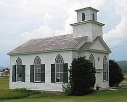
West Haven, Vermont | |
---|---|
Coordinates: 43°39′10″N73°20′48″W / 43.65278°N 73.34667°W | |
Country | United States |
State | Vermont |
County | Rutland |
Area | |
• Total | 28.5 sq mi (73.8 km2) |
• Land | 28.0 sq mi (72.5 km2) |
• Water | 0.5 sq mi (1.3 km2) |
Elevation | 528 ft (161 m) |
Population (2020) | |
• Total | 239 |
• Density | 8.4/sq mi (3.2/km2) |
Time zone | UTC-5 (Eastern (EST)) |
• Summer (DST) | UTC-4 (EDT) |
ZIP code | 05743 |
Area code | 802 |
FIPS code | 50-80875 [1] |
GNIS feature ID | 1462252 [2] |
West Haven is a town in Rutland County, Vermont, United States. The population was 239 at the 2020 census. [3]
According to the United States Census Bureau, the town has a total area of 28.5 square miles (74 km2), of which 28.0 square miles (73 km2) is land and 0.5 square miles (1.3 km2), or 1.72%, is water.
Census | Pop. | Note | %± |
---|---|---|---|
1800 | 430 | — | |
1810 | 679 | 57.9% | |
1820 | 684 | 0.7% | |
1830 | 724 | 5.8% | |
1840 | 774 | 6.9% | |
1850 | 718 | −7.2% | |
1860 | 580 | −19.2% | |
1870 | 713 | 22.9% | |
1880 | 492 | −31.0% | |
1890 | 412 | −16.3% | |
1900 | 355 | −13.8% | |
1910 | 363 | 2.3% | |
1920 | 343 | −5.5% | |
1930 | 280 | −18.4% | |
1940 | 302 | 7.9% | |
1950 | 232 | −23.2% | |
1960 | 220 | −5.2% | |
1970 | 240 | 9.1% | |
1980 | 253 | 5.4% | |
1990 | 273 | 7.9% | |
2000 | 278 | 1.8% | |
2010 | 264 | −5.0% | |
2020 | 239 | −9.5% | |
U.S. Decennial Census [4] |
As of the census [1] of 2000, there were 278 people, 104 households, and 79 families residing in the town. The population density was 9.9 people per square mile (3.8/km2). There were 118 housing units at an average density of 4.2 per square mile (1.6/km2). The racial makeup of the town was 98.20% White, 0.72% African American, 0.36% Asian, and 0.72% from two or more races. Hispanic or Latino of any race were 0.36% of the population.
There were 104 households, out of which 30.8% had children under the age of 18 living with them, 65.4% were married couples living together, 8.7% had a female householder with no husband present, and 24.0% were non-families. 18.3% of all households were made up of individuals, and 8.7% had someone living alone who was 65 years of age or older. The average household size was 2.67 and the average family size was 3.06.
In the town, the population was spread out, with 22.7% under the age of 18, 6.5% from 18 to 24, 27.3% from 25 to 44, 31.7% from 45 to 64, and 11.9% who were 65 years of age or older. The median age was 41 years. For every 100 females, there were 98.6 males. For every 100 females age 18 and over, there were 92.0 males.
The median income for a household in the town was $45,417, and the median income for a family was $48,750. Males had a median income of $34,167 versus $25,313 for females. The per capita income for the town was $22,429. None of the families and 4.0% of the population were living below the poverty line, including no under eighteens and 11.4% of those over 64.
Leicester is a town in Addison County, Vermont, United States. The population was 990 at the 2020 census. Satans Kingdom is an unincorporated community located in Leicester.
Whiting is a town in Addison County, Vermont, United States. The town was named for John Whiting, a landholder. The population was 405 at the 2020 census.
Chittenden is a town in Rutland County, Vermont, United States. The population was 1,237 at the 2020 census.
Hubbardton is a town in Rutland County, Vermont, United States. The town was named for Thomas Hubbard, a landholder. The population was 735 at the 2020 census.
Ira is a town in Rutland County, Vermont, United States. The population was 368 at the 2020 census. It was named for Ira Allen, brother of Ethan Allen, who fought with the Green Mountain Boys of the Revolutionary War.
Killington is a town in Rutland County, Vermont, United States. The population was 1,407 at the 2020 census. Killington Ski Resort and numerous vacation lodges are located here. The town was previously named Sherburne, but was renamed to its original name, "Killington", in 1999.
Mendon is a town in Rutland County, Vermont, United States. The population was 1,149 at the 2020 census.
Middletown Springs is a town in Rutland County, Vermont, United States. The population was 794 at the 2020 census.
Mount Holly is a town in Rutland County, Vermont, United States. It includes the hamlets of Belmont, Healdville, Hortonville, and Tarbellville. The population was 1,385 at the 2020 census.
Mount Tabor is a town in Rutland County, Vermont, United States. The population was 210 at the 2020 census.
Pittsford is a town in Rutland County, Vermont, United States. As of the 2020 census, the town population was 2,862. Named for William Pitt, it has two picket forts used in the American Revolutionary War.
Shrewsbury is a town in Rutland County, Vermont, United States. The town was named for the Earl of Shrewsbury. The population was 1,096 at the 2020 census.
Sudbury is a town in Rutland County, Vermont, United States. The population was 545 at the 2020 census.
Wells is a town in Rutland County, Vermont, United States. As of the 2020 census, the town had a total population of 1,214.
Bridgewater is a town in Windsor County, Vermont, United States. The population was 903 at the 2020 census. Bridgewater contains the hamlets of Bridgewater Village, Bridgewater Corners, West Bridgewater, and Bridgewater Center.
Rutland is a town in Dane County, Wisconsin, United States. The population was 1,977 by the US Census Bureau 2020 census The population was 1,887 at the 2000 census. However, for 2021, the Wisconsin Dept. of Administration declared the population of the Town to be 2,032. The unincorporated communities of Rutland and Stone are located in the town.
Vermont is a town located in Dane County, Wisconsin, United States. The population was 871 at the 2020 Census. The unincorporated communities of Elvers and Vermont are located in the town.
Wallingford is a town in Rutland County, Vermont, United States. The population was 2,129 at the 2020 census. Wallingford also contains the villages of East Wallingford and South Wallingford.
Rutland is a town in Rutland County, Vermont, United States. As of the 2020 census, the population was 3,924. Rutland Town completely surrounds Rutland City, which is a separate municipality. The villages of the town effectively comprise the inner suburbs of Rutland City.
West Rutland is a town in Rutland County, Vermont, United States. The population was 2,214 at the 2020 census. The town center, located in the south-central portion of the town and where about 87% of the population resides, is defined by the U.S. Census Bureau as a census-designated place (CDP). The town is part of the Rutland micropolitan NECTA.