Pittsfield, Vermont

Last updated
Pittsfield, Vermont
Bird's-eye View of Pittsfield, VT.jpg
Bird's-eye view of Pittsfield c.1910
Pittsfield vt highlight.png
Pittsfield, Vermont
Coordinates: 43°46′7″N72°49′53″W / 43.76861°N 72.83139°W / 43.76861; -72.83139 Coordinates: 43°46′7″N72°49′53″W / 43.76861°N 72.83139°W / 43.76861; -72.83139
Country Flag of the United States.svg United States
State Flag of Vermont.svg Vermont
County Rutland
Chartered1781
Area
  Total20.1 sq mi (51.9 km2)
  Land20.1 sq mi (51.9 km2)
  Water0.0 sq mi (0.0 km2)
Elevation
891 ft (272 m)
Population
 (2020)
  Total504
  Density25/sq mi (9.7/km2)
Time zone UTC-5 (Eastern (EST))
  Summer (DST) UTC-4 (EDT)
ZIP code
05762
Area code 802
FIPS code 50-55450 [1]
GNIS feature ID1462173 [2]

Pittsfield is a town in Rutland County, Vermont, United States. The population was 504 at the 2020 census. [3] It is site of the annual Pittsfield Snowshoe Race.

Contents

History

A Pittsfield farmhouse c. 1915 A Residence at Pittsfield, VT.jpg
A Pittsfield farmhouse c.1915

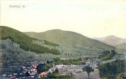
Granted on November 8, 1780, the town was chartered on July 29, 1781, to Samuel Wilcox and 129 others. Pittsfield was named after Pittsfield, Massachusetts, which itself had been named in honor of William Pitt. It was first settled in 1786. The town proved suitable for grazing livestock because of its mountainous terrain. [4] Indeed, in the 19th century, humorists attributed the invention of the one-legged milking stool to Pittsfield, "...as a means of conquering a stern difficulty." [5]

The Farmhouse pictured in this 1915 Postcard to the left still stands and was converted in 1960 to The Fleur De Lis Lodge, for travelers and skiers to stay. Six rooms remain in the original farmhouse, while seven more rooms were added to the new section above the great room.

Pittfield was one of thirteen Vermont towns isolated by flooding caused by Tropical Storm Irene in 2011. [6]

Geography

According to the United States Census Bureau, the town has a total area of 20.0 square miles (52 km2), all land. Set among the Green Mountains, Pittsfield is drained by the Tweed River, a tributary of the White River.

The town is crossed by Vermont Route 100.

Demographics

Historical population
CensusPop.Note
1790 49
1800 164234.7%
1810 338106.1%
1820 45334.0%
1830 50511.5%
1840 61521.8%
1850 512−16.7%
1860 493−3.7%
1870 482−2.2%
1880 55515.1%
1890 468−15.7%
1900 435−7.1%
1910 402−7.6%
1920 343−14.7%
1930 256−25.4%
1940 2591.2%
1950 225−13.1%
1960 25412.9%
1970 249−2.0%
1980 39659.0%
1990 389−1.8%
2000 4279.8%
2010 54627.9%
2020 504−7.7%
U.S. Decennial Census [7]

As of the census [1] of 2000, there were 427 people, 190 households, and 120 families residing in the town. The population density was 21.3 people per square mile (8.2/km2). There were 393 housing units at an average density of 19.6 per square mile (7.6/km2). The racial makeup of the town was 98.36% White, 0.23% Asian, and 1.41% from two or more races. Hispanic or Latino of any race were 0.47% of the population.

There were 190 households, out of which 24.7% had children under the age of 18 living with them, 55.3% were married couples living together, 4.7% had a female householder with no husband present, and 36.8% were non-families. 25.3% of all households were made up of individuals, and 5.3% had someone living alone who was 65 years of age or older. The average household size was 2.25 and the average family size was 2.73.

In the town, the population was spread out, with 19.9% under the age of 18, 3.5% from 18 to 24, 30.4% from 25 to 44, 30.7% from 45 to 64, and 15.5% who were 65 years of age or older. The median age was 41 years. For every 100 females, there were 104.3 males. For every 100 females age 18 and over, there were 109.8 males.

The median income for a household in the town was $41,667, and the median income for a family was $47,000. Males had a median income of $29,306 versus $26,406 for females. The per capita income for the town was $21,837. About 1.6% of families and 4.2% of the population were below the poverty line, including none of those under age 18 and 6.0% of those age 65 or over.

Notable events

In August 2011, Pittsfield become known as one of the most isolated Vermont towns when Tropical Storm Irene destroyed parts of Vermont Route 100 between Killington and Bethel, preventing vehicle travel in and out of the town for weeks. The Giorgetti Covered Bridge was completely destroyed by flood waters, along with 8 homes. As with so many other towns in the area, the geography of this small village has changed significantly; this flood has been compared to the Great Vermont Flood of 1927.

Site of interest

Notable people

Related Research Articles

<span class="mw-page-title-main">Addison County, Vermont</span> County in Vermont, United States

Addison County is a county located in the U.S. state of Vermont. As of the 2020 census, the population was 37,363. Its shire town is the town of Middlebury.

<span class="mw-page-title-main">Granville, Vermont</span> Town in Vermont, United States

Granville is a town in Addison County, Vermont, United States. The population was 301 at the 2020 census. The town was originally called Kingston but was renamed in 1833.

<span class="mw-page-title-main">Hancock, Vermont</span> Town in Vermont, United States

Hancock is a town in Addison County, Vermont, United States. The town was named for John Hancock. The population was 359 at the 2020 census. Hancock is home to the Middlebury College Snow Bowl and contains Middlebury Gap through the Green Mountains.

<span class="mw-page-title-main">North Bennington, Vermont</span> Village in Vermont, United States

North Bennington is an incorporated village in the town of Bennington in Bennington County, Vermont, United States. The population was 1,716 at the 2020 census.

<span class="mw-page-title-main">Strafford, Vermont</span> Town in Vermont, United States

Strafford is a town in Orange County, Vermont, United States. The population was 1,094 at the 2020 census. The town of Strafford was created on August 12, 1761 by way of a royal charter which King George III of Great Britain issued to Governor Benning Wentworth of New Hampshire. The town was named after the Earl of Strafford. Its town house is one of the most famous in Vermont, sitting atop a hill in the historic town square.

<span class="mw-page-title-main">Chittenden, Vermont</span> Town in Vermont, United States

Chittenden is a town in Rutland County, Vermont, United States. The population was 1,237 at the 2020 census.

<span class="mw-page-title-main">Clarendon, Vermont</span> Town in Vermont, United States

Clarendon is a town in Rutland County, Vermont, United States. The population was 2,412 at the 2020 census. Clarendon spans U.S. Route 7 and is split by the highway, the Cold River and Mill River, Otter Creek, and the Green Mountains into the hamlets of Clarendon, West Clarendon, East Clarendon, Clarendon Springs, and North Clarendon

<span class="mw-page-title-main">Ira, Vermont</span> Town in Vermont, United States

Ira is a town in Rutland County, Vermont, United States. The population was 368 at the 2020 census. It was named for Ira Allen, brother of Ethan Allen, who fought with the Green Mountain Boys of the Revolutionary War.

<span class="mw-page-title-main">Killington, Vermont</span> Town in Vermont, United States

Killington is a town in Rutland County, Vermont, United States. The population was 1,407 at the 2020 census. Killington Ski Resort and numerous vacation lodges are located here. The town was previously named Sherburne, but was renamed to its original name, "Killington", in 1999.

<span class="mw-page-title-main">Mendon, Vermont</span> Town in Vermont, United States

Mendon is a town in Rutland County, Vermont, United States. The population was 1,149 at the 2020 census.

<span class="mw-page-title-main">Sudbury, Vermont</span> Town in Vermont, United States

Sudbury is a town in Rutland County, Vermont, United States. The population was 545 at the 2020 census.

<span class="mw-page-title-main">West Haven, Vermont</span> Town in Vermont, United States

West Haven is a town in Rutland County, Vermont, United States. The population was 239 at the 2020 census.

<span class="mw-page-title-main">Moretown, Vermont</span> Town in Vermont, United States

Moretown is a town in Washington County, Vermont, United States. The population was 1,753 at the 2020 census.

<span class="mw-page-title-main">Stratton, Vermont</span> Town in Vermont, United States

Stratton is a town in Windham County, Vermont, United States. The population was 440 at the 2020 census.

<span class="mw-page-title-main">Plymouth, Vermont</span> Town in Vermont, United States

Plymouth is a town in Windsor County, Vermont, United States. The population was 641 at the 2020 census. Calvin Coolidge, the 30th President of the United States, was born and raised in Plymouth and is buried there as well. The State of Vermont Division for Historic Preservation owns and maintains the Coolidge Homestead and the village of Plymouth Notch.

<span class="mw-page-title-main">Rochester, Vermont</span> Town in Vermont

Rochester is a town in Windsor County, Vermont, United States. The population was 1,099 at the 2020 census. The central village is delineated as the Rochester census-designated place.

<span class="mw-page-title-main">Stockbridge, Vermont</span> Town in Vermont, United States

Stockbridge is a town in Windsor County, Vermont, United States, which contains the village of Gaysville. The population was 718 at the 2020 census. Stockbridge was one of thirteen Vermont towns isolated by flooding caused by Hurricane Irene in 2011.

<span class="mw-page-title-main">Rutland, Vermont (town)</span> Town in Vermont, United States

Rutland is a town in Rutland County, Vermont, in the United States. As of the 2020 census, the population was 3,924. The Town of Rutland completely surrounds the City of Rutland, which is incorporated separately from the town. The villages of the town effectively comprise the inner suburbs of the City of Rutland.

<span class="mw-page-title-main">West Rutland, Vermont</span> Town in Vermont, United States

West Rutland is a town in Rutland County, Vermont, United States. The population was 2,214 at the 2020 census. The town center, located in the south-central portion of the town and where about 87% of the population resides, is defined by the U.S. Census Bureau as a census-designated place (CDP). The town is part of the Rutland micropolitan NECTA.

<span class="mw-page-title-main">Wilmington, Vermont</span> Town in Vermont, United States

Wilmington is a town in Windham County, Vermont, United States. The population was 2,255 at the 2020 census.

References

  1. 1 2 "U.S. Census website". United States Census Bureau . Retrieved 2008-01-31.
  2. "US Board on Geographic Names". United States Geological Survey. 2007-10-25. Retrieved 2008-01-31.
  3. "Census - Geography Profile: Pittsfield town, Rutland County, Vermont". United States Census Bureau . Retrieved January 4, 2022.
  4. Hayward's New England Gazetteer of 1839
  5. A. J. Coolidge & J. B. Mansfield, A History and Description of New England; Boston, Massachusetts 1859
  6. Floodwaters From Storm Isolate 13 Vermont Towns, The New York Times
  7. "U.S. Decennial Census". United States Census Bureau. Retrieved May 16, 2015.
  8. Willard, Frances Elizabeth, 1839-1898; Livermore, Mary Ashton Rice, 1820-1905 (1893). A woman of the century; fourteen hundred-seventy biographical sketches accompanied by portraits of leading American women in all walks of life. Buffalo, N.Y., Moulton. p.  337 . Retrieved 8 August 2017.PD-icon.svg This article incorporates text from this source, which is in the public domain .