
Rutland County is a county located in the U.S. state of Vermont. As of the 2020 census, the population was 60,572, making it the second-most populous county in Vermont. Its county seat and most populous municipality is the city of Rutland.

Castleton is a town in Rutland County, Vermont, United States. Castleton is about 15 miles (24 km) to the west of Rutland, the county's seat and most populous city, and about 7 miles (11 km) east of the New York/Vermont state border. The town had a population of 4,458 at the 2020 census. A campus of Vermont State University is located there, with roots dating to 1787.

Middlebury is the main settlement in the town of Middlebury in Addison County, Vermont, United States, and a census-designated place (CDP). The population was 7,304 at the 2020 census, out of a total population of 9,152 in the town of Middlebury. Most of the village is listed on the National Register of Historic Places as the Middlebury Village Historic District.
West Rutland is the central village and a census-designated place (CDP) in the town of West Rutland, Rutland County, Vermont, United States. As of the 2020 census, it had a population of 1,898, out of 2,214 in the entire town of West Rutland.
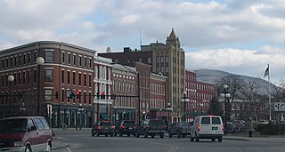
Rutland is the only city in and the seat of Rutland County, Vermont, United States. As of the 2020 census, the city had a total population of 15,807. It is located approximately 65 miles (105 km) north of the Massachusetts state line, 35 miles (56 km) west of New Hampshire state line, and 20 miles (32 km) east of the New York state line. Rutland is the third largest city in the state of Vermont after Burlington and South Burlington. Rutland City is completely surrounded by Rutland Town, which is a separate municipality. The downtown area of the city is listed as a historic district on the National Register of Historic Places.

West Rutland is a town in Rutland County, Vermont, United States. The population was 2,214 at the 2020 census. The town center, located in the south-central portion of the town and where about 87% of the population resides, is defined by the U.S. Census Bureau as a census-designated place (CDP). The town is part of the Rutland micropolitan NECTA.

South Royalton is an unincorporated village and census-designated place (CDP) in the town of Royalton, Windsor County, Vermont, United States. With a population at the 2010 census of 694, South Royalton is the largest community in the town. It is home to the Vermont Law School. The central portion of the village is a historic district, listed on the National Register of Historic Places as the South Royalton Historic District. The Joseph Smith Birthplace Memorial is located approximately two miles to the east. South Royalton is the town pictured in the opening credits of the WB television show Gilmore Girls.
West Pawlet is an unincorporated village and census-designated place (CDP) in the town of Pawlet, Rutland County, Vermont, United States. As of the 2020 census, it had a population of 220, slightly more than the population of the village of Pawlet at the town center.

Arlington is a census-designated place (CDP) in the towns of Arlington and Sunderland, Bennington County, Vermont, United States. The population was 1,213 at the 2010 census.
Pittsford is the central village and a census-designated place (CDP) in the town of Pittsford, Rutland County, Vermont, United States. As of the 2020 census, it had a population of 805, out of 2,862 in the entire town.
Wilmington is the primary village and a census-designated place (CDP) in the town of Wilmington, Windham County, Vermont, United States. As of the 2020 census, it had a population of 439, compared to 2,255 in the entire town. The center of the village is part of the Wilmington Village Historic District.

The Fair Haven Green Historic District encompasses the village green of Fair Haven, Vermont, and the heterogeneous collection of civic, commercial, and residential buildings that line it and adjacent streets. The area was developed mainly following the arrival of the railroad in 1848 and the subsequent expansion of marble and slate quarries in the area. The district was listed on the National Register of Historic Places in 1980.

The Hydeville School is a historic former school building on Vermont Route 4A in Castleton, Vermont. Built in 1898, it is an example of Colonial Revival architecture. It is also historically notable as one of the first schools in the state that was used as a training school for teachers being trained at the normal school in Castleton. The building was listed on the National Register of Historic Places in 1978.

The Wallingford Main Street Historic District encompasses the historic portions of the village of Wallingford, Vermont. An essentially linear district extending along Main Street on either side of School Street, it has a well-preserved array of 19th and early-20th century residential, commercial, and civic buildings. It was listed on the National Register of Historic Places in 1984.
Castleton Four Corners is a census-designated place (CDP) in the town of Castleton, Rutland County, Vermont, United States. It consists of the unincorporated villages of Castleton Corners and Hydeville. As of the 2020 census, the CDP had a population of 699, out of 4,458 in the entire town.
Danby is an unincorporated village and census-designated place (CDP) in the towns of Danby and Mount Tabor, Rutland County, Vermont, United States. As of the 2020 census, it had a population of 200.
Killington Village is a census-designated place (CDP) in the town of Killington, Rutland County, Vermont, United States, comprising residential development associated with Killington Ski Resort. As of the 2020 census, Killington Village had a population of 861, out of 1,407 people in the entire town.
Middletown Springs is the primary village and a census-designated place (CDP) in the town of Middletown Springs, Rutland County, Vermont, United States. As of the 2020 census, it had a population of 194, out of 794 in the entire town.
Proctor is a census-designated place (CDP) that comprises the northern half of the town of Proctor, Rutland County, Vermont, United States, including the unincorporated village of Proctor. As of the 2020 census, the CDP had a population of 1,565, out of 1,763 in the entire town.
West Woodstock is an unincorporated village and census-designated place (CDP) in the town of Woodstock, Windsor County, Vermont, United States. As of the 2020 census, it had a population of 401.


