Rutland County is a county located in the U.S. state of Vermont. As of the 2020 census, the population was 60,572, making it the second-most populous county in Vermont. Its county seat and most populous municipality is the city of Rutland.

Pittsford is a village in Monroe County, New York, United States. The population was 1,355 at the 2010 census. It is named after Pittsford, Vermont, the native town of a founding father. This is the oldest village in New York, incorporated in 1827. The village, an Erie Canal community, is in the town of Pittsford. Pittsford is a suburb of Rochester, New York.
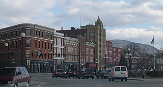
Rutland is the only city in and the seat of Rutland County, Vermont, United States. As of the 2020 census, the city had a total population of 15,807. It is located approximately 65 miles (105 km) north of the Massachusetts state line, 35 miles (56 km) west of New Hampshire state line, and 20 miles (32 km) east of the New York state line. Rutland is the third largest city in the state of Vermont after Burlington and South Burlington. Rutland City is completely surrounded by Rutland Town, which is a separate municipality. The downtown area of the city is listed as a historic district on the National Register of Historic Places.

West Rutland is a town in Rutland County, Vermont, United States. The population was 2,214 at the 2020 census. The town center, located in the south-central portion of the town and where about 87% of the population resides, is defined by the U.S. Census Bureau as a census-designated place (CDP). The town is part of the Rutland micropolitan NECTA.

Arlington is a census-designated place (CDP) in the towns of Arlington and Sunderland, Bennington County, Vermont, United States. The population was 1,213 at the 2010 census.

Castleton is the primary village and a census-designated place (CDP) in the town of Castleton, Rutland County, Vermont, United States. As of the 2020 census, it had a population of 1,337, out of 4,458 in the entire town. A large portion of the village is part of the Castleton Village Historic District, listed on the National Register of Historic Places in 1979. It is also home to Castleton University, founded in 1787, and now part of the Vermont State Colleges system.

The Grafton Village Historic District encompasses the historic village center of the town of Grafton, Vermont. The village was developed in the early-to-mid 19th century, and has retained the character of that period better than many small communities in the state. The district was listed on the National Register of Historic Places in 2010.

The Dorset Village Historic District encompasses a significant portion of the village center of Dorset, Vermont. Centered at the junction of Church Street, Kent Hill Road, and Vermont Route 30, the village was developed between the late 18th and early 20th centuries, and has a number of well-preserved unusual features, including sidewalks of marble from local quarries. The district was listed on the National Register of Historic Places in 1985, and was enlarged to the west in 1997.

The East Arlington Village Historic District encompasses the historic core of a 19th-century village in Arlington and Sunderland, Vermont, United States. It is centered on Old Mill Road, and developed as a mill village beginning in the 18th century. It was listed on the National Register of Historic Places in 1996.

The Colburn Bridge is a historic bridge in Pittsford, Vermont. It is a masonry arch bridge, carrying U.S. Route 7 (US 7) across Sugar Hollow Brook a short way east of the town center. Built in 1899, it is one of a modest number of surviving masonry arch bridges in the state, and exhibits particularly high quality period workmanship. It was listed on the National Register of Historic Places in 1990.

The Danby Village Historic District encompasses much of the town center of Danby, Vermont. It is centered on a stretch of Main Street, roughly between Depot Street and Brook Road. The village has a cohesive collection of mid-19th century architecture, mostly residential, with a modest number of later additions. The district was listed on the National Register of Historic Places in 1983.
The East Poultney Historic District encompasses the historic center of the rural village of East Poultney, Vermont. The district is centered on the triangular green at the center of the village, and was developed mainly from the late 18th through mid-19th centuries, producing a village with strong Federal and Greek Revival architecture. It was listed on the National Register of Historic Places in 1978.

The Fair Haven Green Historic District encompasses the village green of Fair Haven, Vermont, and the heterogeneous collection of civic, commercial, and residential buildings that line it and adjacent streets. The area was developed mainly following the arrival of the railroad in 1848 and the subsequent expansion of marble and slate quarries in the area. The district was listed on the National Register of Historic Places in 1980.

The Marble Bridge, formally known as the Fletcher D. Proctor Memorial Bridge, carries Main Street across Otter Creek in the center of Proctor, Vermont. Built in 1915, and widened in 1935-36, it is a well-preserved example of early concrete bridge construction, and is decoratively faced in local marble. The bridge was listed on the National Register of Historic Places in 1991.

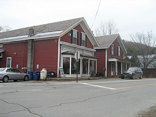
The Marble Street Historic District encompasses what was once the principal business district of West Rutland, Vermont. Centered on Marble Street between Thrall Avenue and Smith Place, this area was the town's economic hub during the years when the local marble quarries dominated the local economy. The area has also been bypassed as a transportation route, resulting in the preservation of a number of period commercial buildings. The district was listed on the National Register of Historic Places in 1990.

The Thomas H. Palmer House is a historic house at 2636 United States Route 7 in Pittsford, Vermont, United States. Built in 1832, it is a relatively upscale brick house, with Federal and Greek Revival styling. It is notable as the home of Thomas Palmer, an influential figure in the development of Pittsford and state-level educational standards in the mid-19th century. The house was listed on the National Register of Historic Places in 1978.

The Poultney Main Street Historic District encompasses the commercial and residential historic core of the village of Poultney, Vermont. Centered on Main Street and East Main Street, between College Avenue and St. Raphael's Catholic Church, the district includes a diversity of architectural styles, as well as civic, religious, and commercial functions spanning a period of more than 100 years. The district was listed on the National Register of Historic Places in 1988.
The Rutland Courthouse Historic District encompasses an architecturally cohesive area of civic and residential buildings in Rutland, Vermont. Roughly bounded by Court, Washington, South Main, and West Streets, the district was principally developed between 1850 and 1875, and includes a number of prominent municipal and county buildings, including the Rutland County courthouse, the Rutland Free Library, and the Grace Congregational United Church. The district was listed on the National Register of Historic Places in 1976.

The Wallingford Main Street Historic District encompasses the historic portions of the village of Wallingford, Vermont. An essentially linear district extending along Main Street on either side of School Street, it has a well-preserved array of 19th and early-20th century residential, commercial, and civic buildings. It was listed on the National Register of Historic Places in 1984.
The Charlotte Center Historic District encompasses the historic 19th-century town center of Charlotte, Vermont. Settled c. 1790 and developed mainly in the mid-19th century, the village, stretched along Church Hill Road west of Hinesburg Road, retains a well-preserved 19th-century atmosphere of residential, civic, and commercial buildings. The district was listed on the National Register of Historic Places in 1984.