The Green Mountain Boys were a militia organization established in 1770 in the territory between the British provinces of New York and New Hampshire, known as the New Hampshire Grants and later in 1777 as the Vermont Republic. Headed by Ethan Allen and members of his extended family, it was instrumental in resisting New York's attempts to control the territory, over which it had won de jure control in a territorial dispute with New Hampshire.

Rutland County is a county located in the U.S. state of Vermont. As of the 2020 census, the population was 60,572, making it the second-most populous county in Vermont. Its county seat and most populous municipality is the city of Rutland.

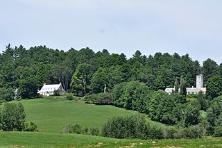
Pittsford is a town in Rutland County, Vermont, United States. As of the 2020 census, the town population was 2,862. Named for William Pitt, it has two picket forts used in the American Revolutionary War.

Pittsford is a village in Monroe County, New York, United States. The population was 1,355 at the 2010 census. It is named after Pittsford, Vermont, the native town of a founding father.

Poultney is a town in Rutland County in the southwestern part of the U.S. state of Vermont. New York state is on its western border. Castleton, Vermont, is on its northern border. Poultney was home to Green Mountain College, a private liberal arts college that closed in 2019. The Village of Poultney is entirely within the town. The town population was 3,020 at the 2020 census.

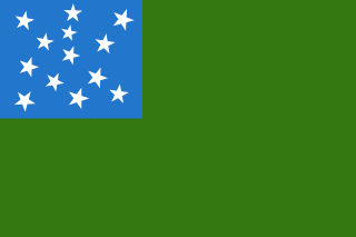
The Vermont Republic, officially known at the time as the State of Vermont, was an independent state in New England that existed from January 15, 1777, to March 4, 1791. The state was founded in January 1777, when delegates from 28 towns met and declared independence from the jurisdictions and land claims of the British colonies of Quebec, New Hampshire, and New York. The republic remained in existence for the next fourteen years, albeit without diplomatic recognition from any foreign power. On March 4, 1791, it was admitted into the United States as the State of Vermont, with the constitution and laws of the independent state continuing in effect after admission.

Seth Warner was an American soldier. He was a Revolutionary War officer from Vermont who rose to rank of Continental colonel and was often given the duties of a brigade commander. He is best known for his leadership in the capture of Fort Crown Point, the Battle of Longueuil, the siege of Quebec, the retreat from Canada, and the battles of Hubbardton and Bennington.
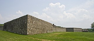
Fort Frederick State Park is a public recreation and historic preservation area on the Potomac River surrounding the restored Fort Frederick, a fortification active in the French and Indian War (1754–1763) and the American Revolutionary War (1775-1783). The state park lies south of the town of Big Pool, Maryland. The Chesapeake and Ohio Canal runs through the park grounds. The site was designated a National Historic Landmark in 1973.
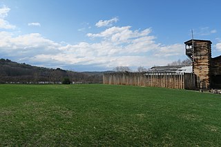
The Fort at Number 4 was a mid-18th century stockade fortification protecting Plantation Number 4, the northernmost British settlement along the Connecticut River in the Province of New Hampshire until after the French and Indian War. It was located in the present-day town of Charlestown, New Hampshire. A recreation of the fort, dating to 1960, now functions as an open-air museum, and was added to the New Hampshire State Register of Historic Places in July 2020.
The Royalton raid was a British-led Indian raid in 1780 against various towns along the White River Valley in the Vermont Republic, and was part of the American Revolutionary War. It was the last major Indian raid in New England.
Carleton's Raid was a British raid led by Major Christopher Carleton in the American War of Independence. It was launched in the fall 1778 from the Province of Quebec against targets in upstate Province of New York.

The northern theater of the American Revolutionary War after Saratoga consisted of a series of battles between American revolutionaries and British forces, from 1778 to 1782 during the American Revolutionary War. It is characterized by two primary areas of activity. The first set of activities was based around the British base of operations in New York City, where each side made probes and counterprobes against the other's positions that sometimes resulted in notable actions. The second was essentially a frontier war in Upstate New York and rural northern Pennsylvania that was largely fought by state militia companies and some Indian allies on the American side, and Loyalist companies supported by Indians, British Indian agents, and occasionally British regulars. The notable exception to significant Continental Army participation on the frontier was the 1779 Sullivan Expedition, in which General John Sullivan led an army expedition that drove the Iroquois out of New York. The warfare amongst the splinters of the Iroquois Six Nations were particularly brutal, turning much of the Indian population into refugees.

Colonel Caleb Hopkins was an officer during the War of 1812 and the first town supervisor of Pittsford, New York, United States.

Mount Independence on Lake Champlain in Orwell, Vermont, was the site of extensive fortifications built during the American Revolutionary War by the American army to stop a British invasion. Construction began in July 1776, following the American defeat in Canada, and continued through the winter and spring of 1777. After the American retreat on July 5 and 6, 1777, British and Hessian troops occupied Mount Independence until November 1777.

Fort Klock, a fortified stone homestead in the Mohawk River Valley of Upstate New York, was built c.1750 by Johannes Klock, and is a good example of a mid-18th century fortified home and trading post, seeing use during the French and Indian War and the American Revolutionary War The fort is located at 7203 Route 5 roughly two miles (3 km) east of the Village of St. Johnsville, New York. Fort Klock is part of a 30-acre (12 ha) complex that includes the historic homestead, a renovated Colonial Dutch Barn, blacksmith shop, and 19th-century schoolhouse. The site is maintained by Fort Klock Historic Restoration and is open seasonally as a living museum. The fort was declared a National Historic Landmark in 1972.

The Crown Point Road, or the Crown Point Military Road, is a historic road built in 1759-60, mostly in what is now the United States state of Vermont. It was built by British Army and colonial militia forces to connect Fort Crown Point near the southern end of Lake Champlain to the Fort at Number 4 in what is now Charlestown, New Hampshire. It was the first major road in Vermont, spurring development along its route after the French and Indian War. Fragments of the road are still visible in largely period condition, or have been paved over, while others have disappeared into the forest. Sections of the road located in Weathersfield have been listed on the National Register of Historic Places.

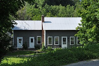
The Gorham Covered Bridge carries Gorham Bridge Road across Otter Creek in a rural area of Pittsford and Proctor, Vermont. It is a Town lattice truss bridge, built in 1841 by Abraham Owen and Nicholas M. Powers, the latter in the early stages of his career as a well-known bridgewright. The bridge was listed on the National Register of Historic Places in 1974.
The Royalton Mill Complex is a three-building residential site in what is now a rural setting of Royalton, Vermont. The two houses and barn are historically associated with a mill, whose breached dams and remnant foundations lie just to the north. One of the houses, built about 1780, is believed to be Royalton's oldest surviving building. The complex was listed on the National Register of Historic Places in 1983.
The William and Agnes Gilkerson Farm, also known more recently as the Kitchel Hill Farm, is a historic farmstead on Kitchel Hill Road in Barnet, Vermont. Established in the late 18th century by Scottish immigrants, it includes one of the finest known examples of a rubblestone farmhouse in the region. The property was listed on the National Register of Historic Places in 1992.
The American Revolutionary War was a war of independence between the Kingdom of Great Britain and the United States that was fought from April 19, 1775 to September 3, 1783. The war was fought as part of the broader American Revolution, in which the Thirteen Colonies made a declaration of independence in response to disputes regarding political representation. The conflict took place in the present-day Eastern United States, which the Thirteen Colonies successfully defended with the assistance of French, Dutch, and Spanish support. American victory led to the creation of the United States.


