The Waterville Village Historic District encompasses most of the history 19th and early 20th-century village center of Waterville, Vermont. The village grew from beginnings late in the 18th century to serve as a modest civic, commercial, and residential hub for the rural community. It was added to the National Register of Historic Places in 2007.

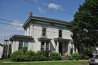
The Granby Center Historic District is a predominantly residential historic district encompassing a portion of the village of Granby Center in Granby, Connecticut. The village developed in the 18th century as a farming center, and a now includes a variety of architectural styles from the late 18th to early 20th centuries. The district was listed on the National Register of Historic Places (NRHP) in 1985.

Vermont Route 140 (VT 140) is a state highway in the U.S. state of Vermont. The highway runs 25.059 miles (40.329 km) from VT 30 in Poultney east to VT 103 in Mount Holly. VT 140 connects the southern Rutland County towns of Poultney, Middletown Springs, Tinmouth, Wallingford, and Mount Holly.

The Whitingham Village Historic District encompasses much of the current village center of Whitingham, Vermont. It was developed mainly in the second half of the 19th century around industries powered by local water sources, and includes well-preserved architecture from that period. It was listed on the National Register of Historic Places in 2006.

The Downtown Bennington Historic District encompasses the historic commercial heart of Bennington, Vermont. Centered on the junction of Main, South, and North Streets, it exhibits a variety of commercial architectural styles from the early 19th to mid-20th century. It was listed on the National Register of Historic Places in 1980, and was enlarged in 2008.

The Danby Village Historic District encompasses much of the town center of Danby, Vermont. It is centered on a stretch of Main Street, roughly between Depot Street and Brook Road. The village has a cohesive collection of mid-19th century architecture, mostly residential, with a modest number of later additions. The district was listed on the National Register of Historic Places in 1983.

The Fair Haven Green Historic District encompasses the village green of Fair Haven, Vermont, and the heterogeneous collection of civic, commercial, and residential buildings that line it and adjacent streets. The area was developed mainly following the arrival of the railroad in 1848 and the subsequent expansion of marble and slate quarries in the area. The district was listed on the National Register of Historic Places in 1980.

The Fox–Cook Farm is a historic farm property on Cook Drive in Wallingford, Vermont. Established in the 1790s, it is one of the oldest surviving farmsteads in the Otter Creek valley south of Wallingford village. It includes a c. 1800 Cape style farmhouse and a c. 1850 barn, among other outbuildings. The property was listed on the National Register of Historic Places in 1986.

The Marble Bridge, formally known as the Fletcher D. Proctor Memorial Bridge, carries Main Street across Otter Creek in the center of Proctor, Vermont. Built in 1915, and widened in 1935-36, it is a well-preserved example of early concrete bridge construction, and is decoratively faced in local marble. The bridge was listed on the National Register of Historic Places in 1991.

The Pittsford Green Historic District encompasses the heart of the traditional village center of Pittsford, Vermont. Centered on a stretch of United States Route 7, the village's development began in the late 18th century, and now consists almost entirely of buildings from the 19th century. The district was listed on the National Register of Historic Places in 1982.

The Poultney Main Street Historic District encompasses the commercial and residential historic core of the village of Poultney, Vermont. Centered on Main Street and East Main Street, between College Avenue and St. Raphael's Catholic Church, the district includes a diversity of architectural styles, as well as civic, religious, and commercial functions spanning a period of more than 100 years. The district was listed on the National Register of Historic Places in 1988.
The Rural Otter Creek Valley Historic District encompasses a rural agricultural area of southern Wallingford, Vermont. It includes nine past and present farmsteads along a stretch of United States Route 7 in the Otter Creek valley, with an agricultural history dating to the early decades of the 19th century. The district was listed on the National Register of Historic Places in 1987.

The Rutland Courthouse Historic District encompasses an architecturally cohesive area of civic and residential buildings in Rutland, Vermont. Roughly bounded by Court, Washington, South Main, and West Streets, the district was principally developed between 1850 and 1875, and includes a number of prominent municipal and county buildings, including the Rutland County courthouse, the Rutland Free Library, and the Grace Congregational United Church. The district was listed on the National Register of Historic Places in 1976.

The Homer Waldo Farm is a historic farm complex on Waldo Lane in Wallingford, Vermont. Developed in the mid-19th century, it resembles a typical detached Vermont hillside farm complex, a contrast to the farms found further south on the valley floor of Otter Creek in southern Wallingford. The property was listed on the National Register of Historic Places in 1986.
The Vergennes Residential Historic District encompasses a neighborhood south of downtown Vergennes, Vermont that encapsulates an architectural cross-section of the city's 19th and early 20th-century residential history. Set on Water, Maple, and Green Streets, it includes houses built and occupied by a diversity of the city's economic classes, from mill owners to laborers. The district was listed on the National Register of Historic Places in 2003.

The Vergennes Historic District encompasses the historic commercial and industrial heart of the city of Vergennes, Vermont. Incorporated in 1788, the city developed as a major industrial center, and served as a military center during the War of 1812. The district includes mainly 19th and early-20th century commercial, retail, residential and civic properties, as well as the former site of the Monkton Iron Works, once one of the nation's largest iron foundries. The district was listed on the National Register of Historic Places in 1976.

The Chelsea Village Historic District encompasses the historic village center of Chelsea, Vermont, the shire town of Orange County. Developed in the first half of the 19th century as a regional service and transportation hub, the village exhibits a significant number of Greek Revival buildings, augmented with primarily later civic and commercial buildings. It was listed on the National Register of Historic Places in 1983.

The Randolph Center Historic District encompasses the historic early town center of Randolph, Vermont. Established in 1783, it was later eclipsed by Randolph Village, which developed around the town's main railroad depot. The village now has a distinguished array of late 18th and early 19th-century architecture, and is home to an academic campus now housing the Vermont Technical College. It was listed on the National Register of Historic Places in 1974.

The Weston Village Historic District encompasses the town center and principal village of Weston, Vermont. Centered on Farrar Park, which serves as the town green, it includes a diversity of architectural styles from the late 18th century to about 1935, and includes residential, civic, commercial, industrial and religious buildings. It was listed on the National Register of Historic Places in 1985.

The Plainfield Village Historic District encompasses a significant portion of the village of Plainfield, Vermont. Located in northernmost Plainfield on United States Route 2, the village grew in the 19th century as a mill town and service community for the surround agricultural areas, and has a well-preserved collection of Greek Revival and Italianate architecture. It was listed on the National Register of Historic Places in 1983.