Rutland is the only city in and the seat of Rutland County, Vermont, United States. As of the 2020 census, the city had a total population of 15,807. It is located approximately 65 miles (105 km) north of the Massachusetts state line, 35 miles (56 km) west of New Hampshire state line, and 20 miles (32 km) east of the New York state line. Rutland is the third largest city in the state of Vermont after Burlington and South Burlington. Rutland City is completely surrounded by Rutland Town, which is a separate municipality. The downtown area of the city is listed as a historic district on the National Register of Historic Places.

West Rutland is a town in Rutland County, Vermont, United States. The population was 2,214 at the 2020 census. The town center, located in the south-central portion of the town and where about 87% of the population resides, is defined by the U.S. Census Bureau as a census-designated place (CDP). The town is part of the Rutland micropolitan NECTA.

The West Canfield Historic District is a neighborhood historic district located primarily on Canfield Avenue between Second and Third Streets in Detroit, Michigan. A boundary increase enlarged the district to include buildings on Third Avenue between Canfield and Calumet. The district was designated a Michigan State Historic Site in 1970 and listed on the National Register of Historic Places in 1971; a boundary increase was added in 1997. The revitalized 1870s era neighborhood is one of the residential areas surrounding the city's Cultural Center Historic District in Midtown. Nearby, East Canfield Avenue leads to the Detroit Medical Center complex, the Romanesque Revival styled St. Josaphat's Catholic Church, and the Gothic revival styled Sweetest Heart of Mary Catholic Church.
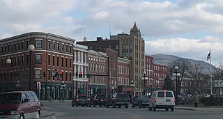
Rutland Downtown Historic District, is the center of government for Rutland, Vermont. The sector of "downtown" is roughly defined as the area between Strongs Avenue, State, Wales, Washington, Pine, and Cottage Streets. The area is also a major center for business, and is considered the most cultural part of Rutland. Much of the area is also listed on the National Register of Historic Places as a historic district and includes 90 contributing properties. Some of these buildings date to the late 18th century, when Rutland was founded, but the greatest amount of expansion in downtown came after the marble industry became established on a large scale after 1850. The city's population tripled between 1850 and 1880, and many of the buildings built in this period were either built with or ornamented with marble.

The Barre Downtown Historic District encompasses the historic commercial and civic heart of the city of Barre, Vermont. Extending along Main Street from City Park to Depot Square, this area was developed quite rapidly in the 1880s and 1890s, when the area experienced rapid growth due to the expansion of the nearby granite quarries. It was listed on the National Register of Historic Places in 1979.

The West Brattleboro Green Historic Districts encompasses the historic core of the village of West Brattleboro, Vermont. Centered in the triangular green at South Street and Western Avenue, it includes a modest collection of buildings constructed between about 1800 and 1910. It was listed on the National Register of Historic Places in 2002.

The Dorset Village Historic District encompasses a significant portion of the village center of Dorset, Vermont. Centered at the junction of Church Street, Kent Hill Road, and Vermont Route 30, the village was developed between the late 18th and early 20th centuries, and has a number of well-preserved unusual features, including sidewalks of marble from local quarries. The district was listed on the National Register of Historic Places in 1985, and was enlarged to the west in 1997.

North Bennington station is a historic railroad station at Depot Street and Buckley Road in North Bennington, Vermont. Built in 1880 as a passenger station, this Second Empire brick building is a surviving reminder of North Bennington's former importance as a major railroad hub in southwestern Vermont. It was listed on the National Register of Historic Places in 1973 as North Bennington Depot.

The Rutland Jewish Center is a non-denominational Jewish synagogue and religious community center located at 96 Grove Street in Rutland, Vermont, in the United States. The synagogue, owned by the Congregation Adath Israel, is located in the former H. H. Baxter Memorial Library building, a Richardsonian Romanesque structure that is listed on the National Register of Historic Places.

The Danby Village Historic District encompasses much of the town center of Danby, Vermont. It is centered on a stretch of Main Street, roughly between Depot Street and Brook Road. The village has a cohesive collection of mid-19th century architecture, mostly residential, with a modest number of later additions. The district was listed on the National Register of Historic Places in 1983.

The Fair Haven Green Historic District encompasses the village green of Fair Haven, Vermont, and the heterogeneous collection of civic, commercial, and residential buildings that line it and adjacent streets. The area was developed mainly following the arrival of the railroad in 1848 and the subsequent expansion of marble and slate quarries in the area. The district was listed on the National Register of Historic Places in 1980.

The Kazon Building is a historic industrial building at 50 Marble Street in West Rutland, Vermont. Built in 1929, it is a well-preserved local example of a purpose-built garment factory, built by Louis Kazon, a leading local businessman in that industry. It was listed on the National Register of Historic Places in 2004. It has been converted to mixed office and residential use.

The Marble Bridge, formally known as the Fletcher D. Proctor Memorial Bridge, carries Main Street across Otter Creek in the center of Proctor, Vermont. Built in 1915, and widened in 1935-36, it is a well-preserved example of early concrete bridge construction, and is decoratively faced in local marble. The bridge was listed on the National Register of Historic Places in 1991.

The Pittsford Green Historic District encompasses the heart of the traditional village center of Pittsford, Vermont. Centered on a stretch of United States Route 7, the village's development began in the late 18th century, and now consists almost entirely of buildings from the 19th century. The district was listed on the National Register of Historic Places in 1982.

The Poultney Main Street Historic District encompasses the commercial and residential historic core of the village of Poultney, Vermont. Centered on Main Street and East Main Street, between College Avenue and St. Raphael's Catholic Church, the district includes a diversity of architectural styles, as well as civic, religious, and commercial functions spanning a period of more than 100 years. The district was listed on the National Register of Historic Places in 1988.

The Proctor-Clement House is a historic house at 85 Field Avenue in Rutland, Vermont. It was built in 1867 for Redfield Proctor, a prominent local lawyer and businessman who came to own the Vermont Marble Company and served as Governor of Vermont. A fine example of Italianate architecture, it now houses the Antique Mansion Bed and Breakfast. It was listed on the National Register of Historic Places in 1982.

The Rutland Courthouse Historic District encompasses an architecturally cohesive area of civic and residential buildings in Rutland, Vermont. Roughly bounded by Court, Washington, South Main, and West Streets, the district was principally developed between 1850 and 1875, and includes a number of prominent municipal and county buildings, including the Rutland County courthouse, the Rutland Free Library, and the Grace Congregational United Church. The district was listed on the National Register of Historic Places in 1976.

The Wallingford Main Street Historic District encompasses the historic portions of the village of Wallingford, Vermont. An essentially linear district extending along Main Street on either side of School Street, it has a well-preserved array of 19th and early-20th century residential, commercial, and civic buildings. It was listed on the National Register of Historic Places in 1984.

The Samuel Paddock Strong House is a historic house at 94 West Main Street in Vergennes, Vermont. Built in the 1830s for a prominent local businessman, it is a well-preserved example of Greek Revival architecture. It was listed on the National Register of Historic Places in 1979. It now houses the Strong House Inn.

New Haven Junction station is a former railway station at the junction of United States Route 7 and Vermont Route 17 in New Haven, Vermont. Probably built in the 1850s, it is a well-preserved example of a first-generation railroad depot. It was listed on the National Register of Historic Places in 1978 as New Haven Junction Depot, and now houses offices.


