Fort Crown Point was built by the combined efforts of British and Colonial troops from New York and the New England Colonies in 1759 at a narrows on Lake Champlain on the border between New York and Vermont. It was erected to secure the region against the French in upstate New York near the town of Crown Point, and it was the largest earthen fortress built in the American colonies. The fort's ruins are a National Historic Landmark administered as part of Crown Point State Historic Site.
The French built a fortress at Crown Point in the 1730s with 12-foot (3.7m) thick limestone walls named Fort Saint-Frédéric. British forces targeted it twice during the French and Indian War before the French destroyed it in the summer of 1759.[3]
The Crown Point fort was constructed by the British army under the command of Sir Jeffery Amherst following the capture of Carillon, a French fort to the south which he renamed Ticonderoga. Amherst used the construction of the fort as a means of keeping his men working through the winter of 1759 after pushing the French into Canada. Israel Putnam supervised much of the construction; he become a general in the American Revolutionary War. According to archaeologist David R. Starbuck, Crown Point was "the greatest British military installation ever raised in North America."[4]
The fort was never directly assaulted. It was completed after the threat of French invasion had ended and was used largely for staging rather than as a military position. On April 21, 1773, a chimney fire broke out in the soldier's barracks. It quickly spread, burning for days.[5] In May 1774, British military engineer John Montresor described the fort after the fire: "the conflagration of the late fort has rendered it an amazing useless mass of earth only".[6] Montresor proposed expanding and improving one of the outworks rather than attempting to repair the main fort.[citation needed]
After the French and Indian War, the British left a skeletal force at the fort. They quickly yielded to Capt. Seth Warner and 100 Green Mountain Boys on May 12, 1775 in the battle of Crown Point at the start of the Revolutionary War. The Americans captured 111 cannons from the British at Crown Point, and transported 29 to Boston for the defense of Boston Harbor.[clarification needed]
The fort was used as a staging ground by Benedict Arnold during the Revolution for his navy on Lake Champlain. That was destroyed in 1776 during the Battle of Valcour Island, and the fort was abandoned to the British in 1777 after the failure of the patriot Invasion of Canada. The British abandoned the fort in 1780, and the United States had no need for it and left it to deteriorate.
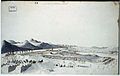
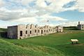
The large earthen walls are still visible today. The fire of April 1773 had entirely destroyed the log and earth fortress. The stone ruins of two barracks buildings at the site are being preserved. The fort was declared a National Historic Landmark in 1968.[2][7][8]
Visits by Founding Fathers
Benjamin Franklin, traveling to Canada, seeking an alliance against the British[3]
1 2 "Fort Crown Point". National Historic Landmark summary listing. National Park Service. September 12, 2007. Archived from the original on May 13, 2011.
↑ Hubbard, Robert Ernest. Major General Israel Putnam: Hero of the American Revolution, pp. 28-31, McFarland & Company, Inc., Jefferson, North Carolina, 2017. ISBN978-1-4766-6453-8.
This page is based on this Wikipedia article Text is available under the CC BY-SA 4.0 license; additional terms may apply. Images, videos and audio are available under their respective licenses.