
Rutland County is a county located in the U.S. state of Vermont. As of the 2020 census, the population was 60,572, making it the second-most populous county in Vermont. Its county seat and most populous municipality is the city of Rutland.

Castleton is a town in Rutland County, Vermont, United States. Castleton is about 15 miles (24 km) to the west of Rutland, the county's seat and most populous city, and about 7 miles (11 km) east of the New York/Vermont state border. The town had a population of 4,458 at the 2020 census. Castleton University is located there, with roots dating to 1787.
St. Johnsbury is a census-designated place (CDP) corresponding to the main settled areas in the town of St. Johnsbury, Caledonia County, Vermont, United States. As of the 2020 census it had a population of 5,994, out of 7,364 in the entire town.
Fair Haven is a town in Rutland County, Vermont, United States. The population was 2,736 at the 2020 census. Within the town is located the census-designated place of Fair Haven. The town is noted for its late 19th century residential and commercial architecture.

Poultney is a town in Rutland County in the southwestern part of the U.S. state of Vermont. New York state is on its western border. Castleton, Vermont, is on its northern border. Poultney was home to Green Mountain College, a private liberal arts college that closed in 2019. The Village of Poultney is entirely within the town. The town population was 3,020 at the 2020 census.
West Rutland is the central village and a census-designated place (CDP) in the town of West Rutland, Rutland County, Vermont, United States. As of the 2020 census, it had a population of 1,898, out of 2,214 in the entire town of West Rutland.

U.S. Route 4 (US 4) in the U.S. state of Vermont extends for 66.059 miles (106.312 km) between the New York state line at Fair Haven and the New Hampshire state line at White River Junction. It is one of the main arteries between New York and New Hampshire.

Bristol is the main settlement in the town of Bristol in Addison County, Vermont, United States, and a census-designated place (CDP). The population was 1,936 at the 2020 census, out of a total population of 3,782 in the town of Bristol.
Randolph is the primary village and a census-designated place (CDP) in the town of Randolph, Orange County, Vermont, United States. As of the 2020 census, it had a population of 2,083, out of 4,774 in the entire town of Randolph.
Benson is the primary village and a census-designated place (CDP) in the town of Benson, Rutland County, Vermont, United States. As of the 2020 census, it had a population of 269, out of 974 in the entire town.
Pittsford is the central village and a census-designated place (CDP) in the town of Pittsford, Rutland County, Vermont, United States. As of the 2020 census, it had a population of 805, out of 2,862 in the entire town.
Wells is the central village and a census-designated place (CDP) in the town of Wells, Rutland County, Vermont, United States. As of the 2020 census, it had a population of 386, out of 1,214 in the entire town.

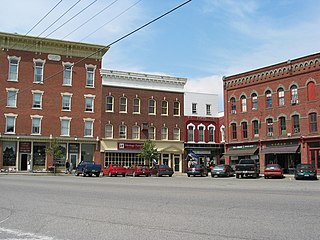
Castleton is the primary village and a census-designated place (CDP) in the town of Castleton, Rutland County, Vermont, United States. As of the 2020 census, it had a population of 1,337, out of 4,458 in the entire town. A large portion of the village is part of the Castleton Village Historic District, listed on the National Register of Historic Places in 1979. It is also home to Castleton University, founded in 1787, and now part of the Vermont State Colleges system.
Lincoln is the central settlement and a census-designated place (CDP) in the town of Lincoln, Addison County, Vermont, United States. It was first listed as a CDP prior to the 2020 census.
Danby is an unincorporated village and census-designated place (CDP) in the towns of Danby and Mount Tabor, Rutland County, Vermont, United States. As of the 2020 census, it had a population of 200.
Killington Village is a census-designated place (CDP) in the town of Killington, Rutland County, Vermont, United States, comprising residential development associated with Killington Ski Resort. As of the 2020 census, Killington Village had a population of 861, out of 1,407 people in the entire town.
Middletown Springs is the primary village and a census-designated place (CDP) in the town of Middletown Springs, Rutland County, Vermont, United States. As of the 2020 census, it had a population of 194, out of 794 in the entire town.
Pawlet is the central village and a census-designated place (CDP) in the town of Pawlet, Rutland County, Vermont, United States. As of the 2020 census, it had a population of 194, out of 1,424 in the entire town.
Londonderry is an unincorporated village and census-designated place (CDP) in the town of Londonderry, Windham County, Vermont, United States. As of the 2020 census, it had a population of 180, compared to 1,919 in the entire town.
West Woodstock is an unincorporated village and census-designated place (CDP) in the town of Woodstock, Windsor County, Vermont, United States. As of the 2020 census, it had a population of 401.


