Prior to the arrival of colonists of European descent, the area was populated by the Abenakis. They used the Connecticut and Nulhegan rivers as primary means of travel through the area along with many subsidiary rivers and streams. The culture was mostly hunter-gatherer with a combination of agriculture, hunting and fishing. While the rivers provided good fishing, the primary food animal was moose.[5]
Vermont was divided into two counties in March 1778. In 1781 the legislature divided the northernmost county, Cumberland, into three counties: Windham and Windsor, in approximately the modern location for those counties. The northern remainder was called Orange County. This latter tract nearly corresponded with the old New York county of Gloucester, organized by that province March 16, 1770, with Newbury as the shire town.[6]
On September 3, 1783, as a result of the signing of the Treaty of Paris, the Revolutionary War ended with Great Britain recognizing the independence of the United States. Vermont's border with Quebec was established at 45 degrees north latitude.[7][8]
On November 5, 1792, the legislature divided Chittenden and Orange counties into six separate counties, as follows: Chittenden, Orange, Franklin, Caledonia, Essex, and Orleans.[6] No reason is given for the county being named after the county of Essex in England.[9]
In 1999, a group of investors bought 86,212 acres (34,889ha) from Champion International Paper for $7.5 million, covering parts of fourteen towns in the county. The state of Vermont and the Freeman Foundation purchased easements for $8.5 million to guarantee traditional uses of the land for logging and recreation. In 2008, Plum Creek Timber company announced plans to purchase this property.[10]
The last murder trial held at the county courthouse took place in 1923. In 1973, a non-resident murdered another non-resident.[11] In 2008, two residents died by homicide – the first in 85 years – when police said a young woman was shot by her boyfriend and a 59-year-old man shot his mother.[12]
In 2012, a study indicated that county residents, overall, were the least healthy in the state. The rating was based on premature death, low birth weight, smoking, obesity, inactivity, excessive drinking, car crashes, sexually transmitted diseases, graduation rates, poverty, violent crime rates, air pollution, limited access to healthy food, unemployment, and the number of single parent households.[13]
U.S. Decennial Census[15] 1790–1960[16] 1900–1990[17] 1990–2000[18] 2010–2020[2]
2020 census
As of the 2020 census, the county had a population of 5,920. Of the residents, 17.4% were under the age of 18 and 26.9% were 65 years of age or older; the median age was 52.1 years. For every 100 females there were 101.8 males, and for every 100 females age 18 and over there were 101.2 males.[19][20]
There were 2,695 households in the county, of which 21.0% had children under the age of 18 living with them and 23.4% had a female householder with no spouse or partner present. About 32.2% of all households were made up of individuals and 16.3% had someone living alone who was 65 years of age or older.[19]
There were 4,867 housing units, of which 44.6% were vacant. Among occupied housing units, 80.1% were owner-occupied and 19.9% were renter-occupied. The homeowner vacancy rate was 3.6% and the rental vacancy rate was 9.3%.[19]
Essex County, Vermont – Racial and ethnic composition Note: the US Census treats Hispanic/Latino as an ethnic category. This table excludes Latinos from the racial categories and assigns them to a separate category. Hispanics/Latinos may be of any race.
As of the 2010 United States census, there were 6,306 people, 2,818 households, and 1,814 families residing in the county.[24] The population density was 9.5 inhabitants per square mile (3.7/km2). There were 5,019 housing units at an average density of 7.6 per square mile (2.9/km2).[25]
Of the 2,818households, 24.2% had children under the age of 18 living with them, 51.0% were married couples living together, 8.7% had a female householder with no husband present, 35.6% were non-families, and 29.3% of all households were made up of individuals. The average household size was 2.23 and the average family size was 2.70. The median age was 47.4 years.[24]
The median income for a household in the county was $37,734 and the median income for a family was $46,263. Males had a median income of $37,021 versus $28,710 for females. The per capita income for the county was $20,040. About 13.0% of families and 16.9% of the population were below the poverty line, including 25.8% of those under age 18 and 10.3% of those age 65 or over.[26]
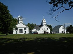
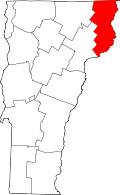
Geography
According to the U.S. Census Bureau, the county has a total area of 675 square miles (1,750km2), of which 664 square miles (1,720km2) is land and 12 square miles (31km2) (1.7%) is water.[27]
In the north central portion of the county the Nulhegan Basin is a circular area roughly 10 miles (16km) in diameter. While the origin of this basin may be either an asteroid hit or ancient volcano it has not been proven as either one so far. Within the basin is a bog and the Silvio O. Conte Fish and Wildlife Refuge with a visitor center, hiking trails, and viewing platforms where one can wait under shelter.
The county has many mountains and waterways. The Northern Forest Canoe Trail passes through this area along the Clyde, Nulhegan, and Connecticut rivers.
In 2011, there were about 1,000 moose in the county. State officials estimated that this was about the "correct number" for a sustainable herd, with the moose not showing signs of starvation, nor the feeding grounds showing signs of overgrazing.[5] In recent years the moose population has been suffering from infestations by ticks. Some moose have been found having as many as 10,000 ticks on one moose, thus causing death from anemia. Warmer winter weather in recent years has prevented the normal die-off of ticks from freezing.
In Vermont, gores and grants are unincorporated portions of a county which are not part on any town and have limited self-government (if any, as many are uninhabited).
In addition, three formally chartered towns have never had sufficient population to organize. Those which are inhabited also have limited self-government.
12Starr, Tina (October 19, 2011). "Biologists keep close watch on moose herd". the Chronicle. Barton, Vermont. p.20.
12Gazetteer of Lamoille and Orleans Counties, VT.; 1883–1884. Hamilton Child. May 1887.
↑Van Zandt, Franklin K. Boundaries of the United States and the Several States. Geological Survey Professional Paper 909. Washington, DC; Government Printing Office, 1976. The Standard Compilation for its subject. P. 12.
This page is based on this Wikipedia article Text is available under the CC BY-SA 4.0 license; additional terms may apply. Images, videos and audio are available under their respective licenses.