National Register of Historic Places listings in Essex County, Vermont

Last updated

Location of Essex County in Vermont Map of Vermont highlighting Essex County.svg
Location of Essex County in Vermont

This is a list of the National Register of Historic Places listings in Essex County, Vermont.

Contents

This is intended to be a complete list of the properties and districts on the National Register of Historic Places in Essex County, Vermont, United States. Latitude and longitude coordinates are provided for many National Register properties and districts; these locations may be seen together in a map. [1]

There are 11 properties and districts listed on the National Register in the county.


    This National Park Service list is complete through NPS recent listings posted March 4, 2022. [2]

Contents: Counties in Vermont
Addison - Bennington - Caledonia - Chittenden - Essex - Franklin - Grand Isle - Lamoille - Orange - Orleans - Rutland - Washington - Windham - Windsor
Map all coordinates using: OpenStreetMap  
Download coordinates as: KML

Current listings

[3] Name on the Register [4] ImageDate listed [5] Location City or townDescription
1 Bloomfield-Nulhegan River Route 102 Bridge
Bloomfield-Nulhegan River Route 102 Bridge BloomfieldVT Rt102NullheganRiverBridge.jpg
Bloomfield-Nulhegan River Route 102 Bridge
November 14, 1991
(#91001605)
VT 102 over the Nulhegan River
44°45′05″N71°38′01″W / 44.751477°N 71.633501°W / 44.751477; -71.633501 (Bloomfield-Nulhegan River Route 102 Bridge)
Bloomfield
2 Columbia Covered Bridge
Columbia Covered Bridge IMG 4229 Columbia Bridge.jpg
Columbia Covered Bridge
December 12, 1976
(#76000123)
Across the Connecticut River between U.S. Route 3 and VT 102
44°51′12″N71°33′05″W / 44.853333°N 71.551389°W / 44.853333; -71.551389 (Columbia Covered Bridge)
Lemington Extends into Coos County, New Hampshire
3 Guildhall Village Historic District
Guildhall Village Historic District Guildhall, Vermont.jpg
Guildhall Village Historic District
September 27, 1980
(#80000331)
VT 102
44°33′56″N71°33′46″W / 44.565556°N 71.562778°W / 44.565556; -71.562778 (Guildhall Village Historic District)
Guildhall
4 Judge David Hibbard Homestead
Judge David Hibbard Homestead ConcordVT JudgeDavidHibbardHomestead.jpg
Judge David Hibbard Homestead
March 31, 1995
(#95000294)
Woodland Rd.
44°27′06″N71°53′30″W / 44.451667°N 71.891667°W / 44.451667; -71.891667 (Judge David Hibbard Homestead)
Concord
5 Island Pond Historic District
Island Pond Historic District Island Pond RR Station.JPG
Island Pond Historic District
January 31, 1979
(#79000275)
Junction of VT 105 and VT 114
44°48′54″N71°52′52″W / 44.815097°N 71.881036°W / 44.815097; -71.881036 (Island Pond Historic District)
Island Pond
6 Jacobs Stand
Jacobs Stand CanaanVT WellsLibrary.jpg
Jacobs Stand
June 3, 1980
(#80000332)
27 Park St.
44°59′45″N71°32′23″W / 44.995833°N 71.539722°W / 44.995833; -71.539722 (Jacobs Stand)
Canaan Now the Alice M. Ward Library.
7 Maidstone State Park
Maidstone State Park Maidstone State Park.jpg
Maidstone State Park
November 29, 2001
(#01001285)
4858 and 4876 Maidstone Rd.
44°38′11″N71°39′07″W / 44.636389°N 71.651944°W / 44.636389; -71.651944 (Maidstone State Park)
Maidstone
8 Mount Orne Covered Bridge
Mount Orne Covered Bridge IMG 4279 Mount Orne Covered Bridge.jpg
Mount Orne Covered Bridge
December 12, 1976
(#76000124)
East of Lunenburg off Town Hwy 1
44°27′38″N71°39′12″W / 44.460556°N 71.653333°W / 44.460556; -71.653333 (Mount Orne Covered Bridge)
Lunenburg Extends into Coos County, New Hampshire
9 U.S. Inspection Station-Canaan, Vermont
U.S. Inspection Station-Canaan, Vermont Canaan Vermont border station north view.jpg
U.S. Inspection Station-Canaan, Vermont
September 10, 2014
(#14000601)
387 VT 141
45°00′43″N71°33′36″W / 45.0119°N 71.56°W / 45.0119; -71.56 (U.S. Inspection Station-Canaan, Vermont)
Canaan
10 U.S. Inspection Station-Beecher Falls, Vermont
U.S. Inspection Station-Beecher Falls, Vermont Beecher Falls border station approach.jpg
U.S. Inspection Station-Beecher Falls, Vermont
September 10, 2014
(#14000602)
1429 VT 253
45°00′46″N71°30′22″W / 45.0128°N 71.5061°W / 45.0128; -71.5061 (U.S. Inspection Station-Beecher Falls, Vermont)
Canaan
11 U.S. Inspection Station-Norton, Vermont
U.S. Inspection Station-Norton, Vermont US Customs Norton Vermont 05907.JPG
U.S. Inspection Station-Norton, Vermont
September 10, 2014
(#14000603)
115 VT 147N
45°00′37″N71°47′39″W / 45.0104°N 71.7941°W / 45.0104; -71.7941 (U.S. Inspection Station-Norton, Vermont)
Norton

See also

Related Research Articles

This is a list of the National Register of Historic Places listings in Addison County, Vermont.

This is a list of the National Register of Historic Places listings in Bennington County, Vermont.

This is a list of the National Register of Historic Places listings in Chittenden County, Vermont.

This is a list of the National Register of Historic Places listings in Rutland County, Vermont.

This is a list of the National Register of Historic Places listings in Orange County, Vermont.

This is a list of the National Register of Historic Places listings in Orleans County, Vermont.

This is a list of the National Register of Historic Places listings in Franklin County, Vermont.

This is a list of the National Register of Historic Places listings in Grand Isle County, Vermont.

This is a list of the National Register of Historic Places listings in Lamoille County, Vermont.

This is a list of the National Register of Historic Places listings in Caledonia County, Vermont.

This is a list of the National Register of Historic Places listings in Windsor County, Vermont.

This is a list of the National Register of Historic Places listings in Washington County, Vermont.

This is a list of the National Register of Historic Places listings in Windham County, Vermont.

National Register of Historic Places listings in Essex County, Virginia

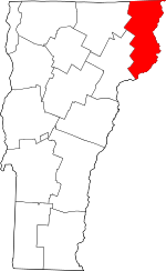
This is a list of the National Register of Historic Places listings in Essex County, Virginia.

National Register of Historic Places listings in Andover, Massachusetts

This is a list of the National Register of Historic Places listings in Andover, Massachusetts.

National Register of Historic Places listings in Lawrence, Massachusetts

The following properties are listed on the National Register of Historic Places in Lawrence, Massachusetts.

National Register of Historic Places listings in Salem, Massachusetts

This is a list of the National Register of Historic Places listings in Salem, Massachusetts.

National Register of Historic Places listings in Lynn, Massachusetts

This is a list of the National Register of Historic Places listings in Lynn, Massachusetts.

National Register of Historic Places listings in Gloucester, Massachusetts

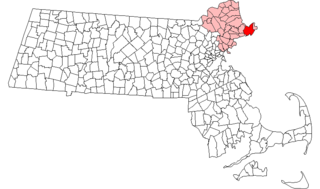
This is a list of the National Register of Historic Places listings in Gloucester, Massachusetts.

National Register of Historic Places listings in Ipswich, Massachusetts

This is a list of the National Register of Historic Places listings in Ipswich, Massachusetts.

References

  1. The latitude and longitude information provided in this table was derived originally from the National Register Information System, which has been found to be fairly accurate for about 99% of listings. Some locations in this table may have been corrected to current GPS standards.
  2. National Park Service, United States Department of the Interior, "National Register of Historic Places: Weekly List Actions", retrieved March 4, 2022.
  3. Numbers represent an alphabetical ordering by significant words. Various colorings, defined here, differentiate National Historic Landmarks and historic districts from other NRHP buildings, structures, sites or objects.
  4. "National Register Information System". National Register of Historic Places . National Park Service. April 24, 2008.
  5. The eight-digit number below each date is the number assigned to each location in the National Register Information System database, which can be viewed by clicking the number.