Brighton, Vermont

Last updated

Brighton, Vermont
Town
Island Pond 6.JPG
Village of Island Pond in Brighton
Essex County Vermont incorporated and unincorporated areas Brighton highlighted.svg
Location in Essex County and the state of Vermont.
Map of USA VT.svg
Location of Vermont with the U.S.A.
Coordinates: 44°48′32″N71°52′10″W / 44.80889°N 71.86944°W / 44.80889; -71.86944
Country United States
State Vermont
County Essex
Chartered1781
Settled1824
Organized1832
Community Island Pond
Government
  Type New England town
Area
  Total53.3 sq mi (138.1 km2)
  Land51.9 sq mi (134.3 km2)
  Water1.5 sq mi (3.8 km2)
Elevation
1,280 ft (365 m)
Population
 (2020)
  Total1,157
  Density22/sq mi (8.6/km2)
  Households
529
  Families
356
Time zone UTC-5 (EST)
  Summer (DST) UTC-4 (EDT)
ZIP code
05846
Area code 802
FIPS code 50-08725 [1]
GNIS feature ID1462052 [2]
Website brightonvt.org

Brighton is a town in Essex County, Vermont, United States. The population was 1,157 at the 2020 census. [3] The town was named "Gilead" in its original grant in 1780. The town was sold to a group consisting primarily of soldiers commanded by Colonel Joseph Nightingale and subsequently named "Random". The town's name was finally changed by the legislature to "Brighton" in 1832. The Brighton village of Island Pond gets its name from the Abenaki word Menanbawk, which literally means island pond.

Contents

Brighton is part of the Berlin, NH-VT Micropolitan Statistical Area.

Geography

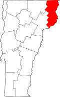
Brighton is in western Essex County, bordered to the north by Warren's Gore and Averys Gore, to the northeast by Lewis, to the southeast by Ferdinand, to the southwest by Newark in Caledonia County and Westmore in Orleans County, and to the northwest by Charleston and Morgan in Orleans County. The unincorporated community of Island Pond, the main community in the town, is at the north end of the lake of the same name in the center of the town.

According to the United States Census Bureau, the town of Brighton has a total area of 53.3 square miles (138.1 km2), of which 51.9 square miles (134.3 km2) is land and 1.5 square miles (3.8 km2), or 2.76%, is water. [4] Island Pond, originally called "Knowlton Pond" in the 19th century to honor Luke Knowlton, who surveyed and laid out the town, is Brighton's largest body of water. The Clyde River flows out of the north end of Island Pond and proceeds in a northwesterly direction towards Charleston. Spectacle Pond is a kettle lake just east (upstream) of Island Pond. It is only 8 to 10 feet (2.4 to 3.0 m) deep, with a thick bottom of muck. [5] Most of the town, including Island and Spectacle ponds and the Clyde River, is part of the Lake Memphremagog watershed, and thus part of the Saint Lawrence River basin, via the Magog and Saint-François rivers of Quebec. The east side of the town drains to the Connecticut River, mostly to the east via the Nulhegan River, but a small portion to the south via the East Branch of the Passumpsic River. The highest point in Brighton is the 2,789-foot (850 m) southern summit of Bluff Mountain, in the northern part of the town.

Vermont Routes 114 and 105 cross the town, joining as Derby Street through Island Pond. Route 114 leads north 16 miles (26 km) to the Canada–United States border at Norton, Vermont, and south 24 miles (39 km) to Lyndonville. Route 105 leads east 16 miles (26 km) to Bloomfield on the Connecticut River and northwest 17 miles (27 km) through Charleston to Derby Center.

History

In 1957, a 67-foot (20 m) white spruce was chosen from the town for display as the Rockefeller Center Christmas Tree. [6]

Demographics

Historical population
CensusPop.Note
1810 144
1830 105
1840 15749.5%
1850 19322.9%
1860 945389.6%
1870 1,53562.4%
1880 1,69110.2%
1890 2,02019.5%
1900 2,0230.1%
1910 2,013−0.5%
1920 2,28013.3%
1930 2,002−12.2%
1940 1,754−12.4%
1950 1,671−4.7%
1960 1,545−7.5%
1970 1,365−11.7%
1980 1,55714.1%
1990 1,5620.3%
2000 1,260−19.3%
2010 1,222−3.0%
2020 1,157−5.3%
U.S. Decennial Census [7]

The racial make up is 95.4% White, 1.2% Asian and 3.1% from two or more races. As of the census [1] of 2000, there were 1,260 people, 529 households, and 356 families residing in the town. The population density was 24.1 inhabitants per square mile (9.3/km2). There were 891 housing units at an average density of 17.1 per square mile (6.6/km2).

There were 529 households, out of which 30.2% had children under the age of 18 living with them, 51.8% were couples living together and joined in either marriage or civil union, 11.7% had a female householder with no husband present, and 32.7% were non-families. 27.6% of all households were made up of individuals, and 15.5% had someone living alone who was 65 years of age or older. The average household size was 2.38 and the average family size was 2.88.

In the town, the population was spread out, with 25.0% under the age of 18, 7.8% from 18 to 24, 23.8% from 25 to 44, 25.2% from 45 to 64, and 18.2% who were 65 years of age or older. The median age was 41 years. For every 100 females, there were 94.7 males. For every 100 females age 18 and over, there were 91.3 males.

Economy

Personal income

The median income for a household in the town was $26,932, and the median income for a family was $31,316. Males had a median income of $26,413 versus $23,125 for females. The per capita income for the town was $12,999. About 14.9% of families and 19.2% of the population were below the poverty line, including 28.7% of those under age 18 and 15.3% of those age 65 or over.

Industry

Tourism

The Brighton Snowmobile Club maintains 130 miles (210 km) of trails during the winter. [8]

Media

WVTI 106.9 broadcasts from Island Pond. [9]

Related Research Articles

<span class="mw-page-title-main">Essex County, Vermont</span> County in Vermont, United States

Essex County is a county located in the northeastern part of the U.S. state of Vermont. As of the 2020 census, the population was 5,920, making it the least-populous county in both Vermont and New England. Its shire town is the municipality of Guildhall. The county was created in 1792 and organized in 1800. Bordered by the Connecticut River next to New Hampshire, Essex County is south of the Canadian province of Quebec. It is the county with the lowest household-income in Vermont.

<span class="mw-page-title-main">Chesterfield, New York</span> Town in New York, United States

Chesterfield is a town in Essex County, New York, United States. The population was 2,445 at the 2010 census. The name possibly is from a location in New England.

<span class="mw-page-title-main">Elizabethtown, New York</span> Town in New York, United States

Elizabethtown is a town in Essex County, New York, United States. The population was 1,163 at the 2010 census. The county seat of Essex County is the hamlet of Elizabethtown, located in the northern part of the town. The name is derived from Elizabeth Gilliland, the wife of an early settler.

<span class="mw-page-title-main">Minerva, New York</span> Town in New York, United States

Minerva is a town in Essex County, New York, United States. The population was 773 at the 2020 census. The town is named after Minerva, the Roman goddess of wisdom. The town has a highly irregular polygonal shape. It is located in the southwestern corner of the county. By road, it is 40 miles (64 km) north-northwest of Queensbury, 85 miles (137 km) southwest of Burlington, Vermont, 88 miles (142 km) south of Plattsburgh, 93 miles (150 km) north of Albany, and 147 miles (237 km) south of Montreal, Quebec.

<span class="mw-page-title-main">Newark, Vermont</span> Town in Vermont, United States

Newark is a town in Caledonia County, Vermont, United States. The population was 584 at the 2020 census.

<span class="mw-page-title-main">Averill, Vermont</span> Town in Vermont, United States

Averill is an unincorporated town in Essex County, Vermont, United States. The town was named for Samuel Averill, a landholder. The town was never formally incorporated, having never gained a large enough permanent population. The population was 21 at the 2020 census. The town's affairs are handled by the Unified Towns & Gores of Essex County. It is part of the Berlin, New Hampshire Vermont Micropolitan Statistical Area.

<span class="mw-page-title-main">Bloomfield, Vermont</span> Town in Vermont, United States

Bloomfield is a town in Essex County, Vermont, United States. The population was 217 at the 2020 census. It is part of the Berlin, New Hampshire-Vermont Micropolitan Statistical Area.

<span class="mw-page-title-main">Brunswick, Vermont</span> Town in Vermont, United States

Brunswick is a town in Essex County, Vermont, United States. The town was named after Prince Karl Wilhelm Ferdinand of Brunswick-Lunenburg. The population was 88 at the 2020 census. It is part of the Berlin, NH-VT Micropolitan Statistical Area. Brunswick is home to six mineral springs that made the town a popular resort destination in the 19th century. The land the springs are on is now owned by the Abenaki people.

<span class="mw-page-title-main">Concord, Vermont</span> Town in Vermont, United States

Concord is a town in Essex County, Vermont, United States. The population was 1,141 at the 2020 census. It is part of the Berlin, NH–VT Micropolitan Statistical Area.

<span class="mw-page-title-main">Ferdinand, Vermont</span> Town in Vermont, United States

Ferdinand is a town in Essex County, Vermont, United States. It was named after German Prince Karl Wilhelm Ferdinand of Brunswick-Lunenburg. Although incorporated, it was never formally organized since it never gained a sufficiently large permanent population. Its population was 16 at the 2020 census and was highest in 1910, with 213. It is managed by the Unified Towns & Gores of Essex County. It is part of the Berlin, NH–VT Micropolitan Statistical Area.

<span class="mw-page-title-main">Guildhall, Vermont</span> Town in Vermont, United States

Guildhall is a town in and the shire town of Essex County, Vermont, United States. As of the 2020 census, the population was 262. According to a large sign in the town center, it is the only town in the world so named. The name derives from a meeting house on the square called the Guildhall.

<span class="mw-page-title-main">Island Pond, Vermont</span> Census-designated place in Vermont, United States

Island Pond is a census-designated place (CDP) in the town of Brighton in Essex County, Vermont, United States. The population was 750 at the 2020 census. It is part of the Berlin, NH–VT Micropolitan Statistical Area.

<span class="mw-page-title-main">Lemington, Vermont</span> Town in Vermont, United States

Lemington is a town in Essex County, Vermont, United States. The population was 87 as of the 2020 census. It is part of the Berlin, NH–VT Micropolitan Statistical Area.

<span class="mw-page-title-main">Lunenburg, Vermont</span> Town in Vermont, United States

Lunenburg is a town in Essex County, Vermont, United States. The population was 1,246 at the 2020 census, the most populous in Essex County. Lunenburg contains the villages of Lunenburg and Gilman and hamlets of West Lunenburg, South Lunenburg, and Mill Village, and is part of the Berlin, NH–VT Micropolitan Statistical Area.

<span class="mw-page-title-main">Maidstone, Vermont</span> Town in Vermont, United States

Maidstone is a town in Essex County, Vermont, United States. As of the 2020 census, the town had a population of 211. It is part of the Berlin, NH–VT Micropolitan Statistical Area. There is no town center or gas station, but there is a town office building in the southern part of the town.

<span class="mw-page-title-main">Norton, Vermont</span> Town in Vermont, United States

Norton is a town in Essex County, Vermont, United States. The population was 153 at the 2020 census. It is part of the Berlin, NH–VT Micropolitan Statistical Area. It is located on the Canada–US border, immediately south of Stanhope, Quebec.

<span class="mw-page-title-main">Richford, Vermont</span> Town in Vermont, United States

Richford is a town in Franklin County, Vermont, United States, located along the Canada–United States border. The population was 2,346 at the 2020 census.

<span class="mw-page-title-main">Wolcott, Vermont</span> Town in Vermont, United States

Wolcott is a town in Lamoille County, Vermont, United States. The town was named for General Oliver Wolcott, a signer of the Declaration of Independence. The population was 1,670 at the 2020 census.

<span class="mw-page-title-main">Charleston, Vermont</span> Town in Vermont, United States

Charleston is a town in Orleans County, Vermont, United States. The population was 1,021 at the 2020 census. The town contains two unincorporated villages: East Charleston and West Charleston.

<span class="mw-page-title-main">Albany, Vermont</span> Town in Vermont, United States

Albany is a town in Orleans County, Vermont, United States. The population was 976 at the 2020 census. Albany contains four villages: the incorporated village of Albany, and the unincorporated villages of Albany Center, East Albany and South Albany.

References

  1. 1 2 "U.S. Census website". United States Census Bureau . Retrieved January 31, 2008.
  2. "US Board on Geographic Names". United States Geological Survey. October 25, 2007. Retrieved January 31, 2008.
  3. "Census - Geography Profile: Brighton town, Essex County, Vermont". United States Census Bureau . Retrieved December 28, 2021.
  4. "Geographic Identifiers: 2010 Census Summary File 1 (G001): Brighton town, Essex County, Vermont". American Factfinder. U.S. Census Bureau. Archived from the original on February 13, 2020. Retrieved March 31, 2016.
  5. Johnson, Charles W. (1984). The Nature of Vermont. University Press of New England.
  6. Hunt, Pat (December 2008). Vermont's Northland Journal. 7 (9): 6.{{cite journal}}: Missing or empty |title= (help)
  7. "U.S. Decennial Census". United States Census Bureau. Retrieved May 16, 2015.
  8. Creaser, Richard (February 11, 2009). Myers handles groomer for I.P. club. the Chronicle.
  9. VPR (October 28, 2008). VPR Classical broadcasts from I.P. the Chronicle.