
Montpelier is the capital of the U.S. state of Vermont and the county seat of Washington County. The site of Vermont's state government, it is the least populated state capital in the United States. As of the 2020 census, the population was 8,074, with a daytime population growth of about 21,000 due to the large number of jobs within city limits. The Vermont College of Fine Arts is located in the municipality. It was named after Montpellier, a city in the south of France.

Rutland County is a county located in the U.S. state of Vermont. As of the 2020 census, the population was 60,572, making it the second-most populous county in Vermont. Its county seat and most populous municipality is the city of Rutland.

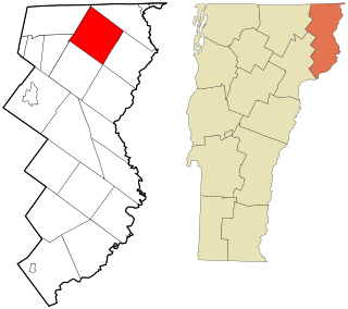
Essex County is a county located in the northeastern part of the U.S. state of Vermont. As of the 2020 census, the population was 5,920, making it the least-populous county in both Vermont and New England. Its shire town is the municipality of Guildhall. The county was created in 1792 and organized in 1800. Bordered by the Connecticut River next to New Hampshire, Essex County is south of the Canadian province of Quebec. It is the county with the lowest household-income in Vermont.

Chittenden County is the most populous county in the U.S. state of Vermont. As of the 2020 census, its population was 168,323. The county seat is Vermont's most populous municipality, the city of Burlington. The county has over a quarter of Vermont's population and more than twice the population of Vermont's second-most populous county, Rutland. The county also has more than twice the population density of Vermont's second-most dense county, Washington. The county is named for Vermont's first governor and one of the framers of its constitution as an independent republic and later U.S. state, Thomas Chittenden.

Waterford is a town in Caledonia County, Vermont, United States. The population was 1,268 at the 2020 census.

Williston is a town in Chittenden County, Vermont, United States. Originally rural and laid out with many farms, in recent decades it has developed into a thriving suburb of Burlington, the largest city in the state of Vermont. As of the 2020 census, the population of Williston was 10,103, an increase of over 1,000 people since the 2010 census. Williston is one of the fastest-growing towns in Vermont, and while becoming more populated, it has also developed as a major retail center for the Burlington area as well as much of central and northern Vermont. The town has a National Register Historic District in its unincorporated central village.
Averill is an unincorporated town in Essex County, Vermont, United States. The town was named for Samuel Averill, a landholder. The town was never formally incorporated, having never gained a large enough permanent population. The population was 21 at the 2020 census. The town's affairs are handled by the Unified Towns & Gores of Essex County. It is part of the Berlin, New Hampshire Vermont Micropolitan Statistical Area.

Bloomfield is a town in Essex County, Vermont, United States. The population was 217 at the 2020 census. It is part of the Berlin, New Hampshire-Vermont Micropolitan Statistical Area.

Brighton is a town in Essex County, Vermont, United States. The population was 1,157 at the 2020 census. The town was named "Gilead" in its original grant in 1780. The town was sold to a group consisting primarily of soldiers commanded by Colonel Joseph Nightingale and subsequently named "Random". The town's name was finally changed by the legislature to "Brighton" in 1832. The Brighton village of Island Pond gets its name from the Abenaki word Menanbawk, which literally means island pond.

Concord is a town in Essex County, Vermont, United States. The population was 1,141 at the 2020 census. It is part of the Berlin, NH–VT Micropolitan Statistical Area.

Ferdinand is a town in Essex County, Vermont, United States. It was named after German Prince Karl Wilhelm Ferdinand of Brunswick-Lunenburg. Although incorporated, it was never formally organized since it never gained a sufficiently large permanent population. Its population was 16 at the 2020 census and was highest in 1910, with 213. It is managed by the Unified Towns & Gores of Essex County. It is part of the Berlin, NH–VT Micropolitan Statistical Area.
Guildhall is a town in and the shire town of Essex County, Vermont, United States. As of the 2020 census, the population was 262. According to a large sign in the town center, it is the only town in the world so named. The name derives from a meeting house on the square called the Guildhall.

Lewis is a town in Essex County, Vermont, United States. The town was named for landholders Nathan, Sevignior, and Timothy Lewis. Although incorporated by the state, the town was never formally organized, since it never gained a sufficiently large permanent population. For most of the 20th century, the town had a total population of zero. It reported a population of 2 at the 2020 census; however it is possible due to the town sharing a census block with nearby towns and gores and the introduction of differential privacy in for the 2020 census, that the actual population remained at 0. Indeed, 100% of the town's land that is not federally protected is owned by a single logging company, Weyerhaeuser. The town's affairs are handled by the Unified Towns & Gores Of Essex County.

Warner's Grant is a gore located in Essex County, Vermont, United States. At the 2020 Census, the grant had a total population of 0. In Vermont, gores and grants are unincorporated portions of a county which are not part of any town and have limited self-government. Warner's Grant is named after Seth Warner, a leader of the Green Mountain Boys.

Warren's Gore is a gore in Essex County, Vermont, United States. The population was 2 at the 2020 census, down from 4 at the 2010 census. In Vermont, gores and grants are unincorporated portions of a county which are not part of any town and have limited self-government. Warren's Gore is part of the Berlin, NH–VT Micropolitan Statistical Area.

Montgomery is a town in Franklin County, Vermont, United States. The population as of the 2020 census was 1,184. In 1963, part of Avery's Gore in Franklin County became part of Montgomery, with the other section becoming part of Belvidere in Lamoille County.

Cambridge is a town in Lamoille County, Vermont, United States. The population was 3,839 at the 2020 United States Census. Cambridge includes the villages of Jeffersonville and Cambridge.
The Berlin Micropolitan Statistical Area is the core-based statistical area centered on the urban cluster associated with the city Berlin, New Hampshire, in the United States. As defined by the Office of Management and Budget using counties as building blocks, the area consists of two counties – Coös County in New Hampshire, which contains the city of Berlin, and the adjacent Essex County in Vermont.
The Nulhegan Band of the Coosuk Abenaki Nation is a state-recognized tribe and nonprofit organization, called AHA "Abenaki Helping Abenaki", whose headquarters and land are based in Vermont. They are often referred to as the Nulhegan Abenaki Tribe or simply, Nulhegan.

The Nulhegan River is a 15.1-mile-long (24.3 km) tributary of the Connecticut River in Essex County, Vermont.

