Ferdinand, Vermont

Last updated

Ferdinand, Vermont
Town
Essex County Vermont incorporated and unincorporated areas Ferdinand highlighted.svg
Location in Essex County and the state of Vermont.
Map of USA VT.svg
Location of Vermont in the United States
Coordinates: 44°43′01″N71°46′36″W / 44.71694°N 71.77667°W / 44.71694; -71.77667
Country United States
State Vermont
County Essex
Government
  Type(de facto) Unincorporated town
Area
  Total52.8 sq mi (136.8 km2)
  Land52.6 sq mi (136.2 km2)
  Water0.2 sq mi (0.6 km2)
Population
 (2020)
  Total16
  Density0.3/sq mi (0.1/km2)
Time zone UTC-5 (EST)
  Summer (DST) UTC-4 (EDT)
ZIP code
05905

Ferdinand is a town in Essex County, Vermont, United States. It was named after German Prince Karl Wilhelm Ferdinand of Brunswick-Lunenburg. [1] Although incorporated, it was never formally organized since it never gained a sufficiently large permanent population. Its population was 16 at the 2020 census [2] and was highest in 1910, with 213. It is managed by the Unified Towns & Gores of Essex County. It is part of the Berlin, NH VT Micropolitan Statistical Area.

Contents

Geography

Ferdinand is in central Essex County and is bordered to the northwest by Brighton, to the north by Lewis, to the east by Brunswick and Maidstone, and to the south by Granby and East Haven. A small part of the southwestern boundary is with the town of Newark in Caledonia County. Vermont Route 105 crosses the northern part of the town, running between Island Pond to the west and Bloomfield to the east.

According to the United States Census Bureau, the town has a total area of 52.8 square miles (136.8 km2), of which 52.6 square miles (136.2 km2) is land and 0.2 square miles (0.6 km2), or 0.43%, is water. [3] The Nulhegan River, a tributary of the Connecticut River, flows from west to east across the northern part of the town. The highest point in the town is the summit of Seneca Mountain, at 3,170 feet (970 m).

Demographics

Historical population
CensusPop.Note
1860 34
1870 33−2.9%
1880 4021.2%
1890 7382.5%
1900 41−43.8%
1910 213419.5%
1920 106−50.2%
1930 18−83.0%
1940 17−5.6%
1950 10−41.2%
1960 1660.0%
1970 14−12.5%
1980 12−14.3%
1990 2391.7%
2000 3343.5%
2010 32−3.0%
2020 16−50.0%
U.S. Decennial Census [4]

As of the census [5] of 2000, there were 33 people (30% of which spoke French at home due largely to the town's proximity to the Province of Quebec), 13 households, and 13 families residing in the town. The population density was 0.6 inhabitants per square mile (0.23/km2). There were 56 housing units at an average density of 1.1 per square mile (0.42/km2). The racial makeup of the town was 100.00% White.

There were 13 households, out of which 23.1% had children under the age of 18 living with them, 92.3% were married couples living together, 7.7% had a female householder with no husband present, and 0.0% were non-families. No households were made up of individuals, and none had someone living alone who was 65 years of age or older. The average household size was 2.54 and the average family size was 2.54.

In the town, the population was spread out, with 21.2% under the age of 18, 3.0% from 18 to 24, 15.2% from 25 to 44, 24.2% from 45 to 64, and 36.4% who were 65 years of age or older. The median age was 54 years. For every 100 females, there were 135.7 males. For every 100 females age 18 and over, there were 100.0 males.

The median income for a household in the town was $14,688, and the median income for a family was $13,750. Males had a median income of $24,167 versus $0 for females. The per capita income for the town was $9,138. There were 35.7% of families and 48.9% of the population living below the poverty line, including 100.0% of under eighteens and 21.4% of those over 64.

Related Research Articles

<span class="mw-page-title-main">Newark, Vermont</span> Town in Vermont, United States

Newark is a town in Caledonia County, Vermont, United States. The population was 584 at the 2020 census.

<span class="mw-page-title-main">Stannard, Vermont</span> Town in Vermont, United States

Stannard is a town in Caledonia County, Vermont. The population was 208 at the 2020 census. The town has no paved roads.

<span class="mw-page-title-main">Waterford, Vermont</span> Town in Vermont, United States

Waterford is a town in Caledonia County, Vermont, United States. The population was 1,268 at the 2020 census.

<span class="mw-page-title-main">Averill, Vermont</span> Town in Vermont, United States

Averill is an unincorporated town in Essex County, Vermont, United States. The town was named for Samuel Averill, a landholder. The town was never formally incorporated, having never gained a large enough permanent population. The population was 21 at the 2020 census. The town's affairs are handled by the Unified Towns & Gores of Essex County. It is part of the Berlin, New Hampshire Vermont Micropolitan Statistical Area.

<span class="mw-page-title-main">Bloomfield, Vermont</span> Town in Vermont, United States

Bloomfield is a town in Essex County, Vermont, United States. The population was 217 at the 2020 census. It is part of the Berlin, New Hampshire-Vermont Micropolitan Statistical Area.

<span class="mw-page-title-main">Brighton, Vermont</span> Town in Vermont, United States

Brighton is a town in Essex County, Vermont, United States. The population was 1,157 at the 2020 census. The town was named "Gilead" in its original grant in 1780. The town was sold to a group consisting primarily of soldiers commanded by Colonel Joseph Nightingale and subsequently named "Random". The town's name was finally changed by the legislature to "Brighton" in 1832. The Brighton village of Island Pond gets its name from the Abenaki word Menanbawk, which literally means island pond.

<span class="mw-page-title-main">Brunswick, Vermont</span> Town in Vermont, United States

Brunswick is a town in Essex County, Vermont, United States. The town was named after Prince Karl Wilhelm Ferdinand of Brunswick-Lunenburg. The population was 88 at the 2020 census. It is part of the Berlin, NH-VT Micropolitan Statistical Area. Brunswick is home to six mineral springs that made the town a popular resort destination in the 19th century. The land the springs are on is now owned by the Abenaki people.

<span class="mw-page-title-main">Canaan, Vermont</span> Town in Vermont, United States

Canaan is a town in Essex County, Vermont, United States. The population was 896 at the 2020 census. Canaan contains the village of Beecher Falls, located at the confluence of the Connecticut River and Halls Stream. It is part of the Berlin, NH-VT Micropolitan Statistical Area.

<span class="mw-page-title-main">Concord, Vermont</span> Town in Vermont, United States

Concord is a town in Essex County, Vermont, United States. The population was 1,141 at the 2020 census. It is part of the Berlin, NH–VT Micropolitan Statistical Area.

<span class="mw-page-title-main">Granby, Vermont</span> Town in Vermont, United States

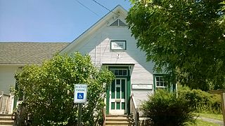
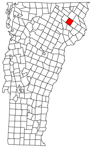
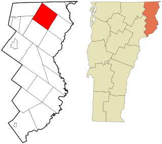
Granby is a town in Essex County, Vermont, United States. The town was named for the Marquis of Granby. The population was 81 at the 2020 census. Granby is part of the Berlin, NH–VT Micropolitan Statistical Area. Granby was one of the last two towns in Vermont to be linked to the electric grid, in 1963.

<span class="mw-page-title-main">Lemington, Vermont</span> Town in Vermont, United States

Lemington is a town in Essex County, Vermont, United States. The population was 87 as of the 2020 census. It is part of the Berlin, NH–VT Micropolitan Statistical Area.

<span class="mw-page-title-main">Lunenburg, Vermont</span> Town in Vermont, United States

Lunenburg is a town in Essex County, Vermont, United States. The population was 1,246 at the 2020 census, the most populous in Essex County. Lunenburg contains the villages of Lunenburg and Gilman and hamlets of West Lunenburg, South Lunenburg, and Mill Village, and is part of the Berlin, NH–VT Micropolitan Statistical Area.

<span class="mw-page-title-main">Maidstone, Vermont</span> Town in Vermont, United States

Maidstone is a town in Essex County, Vermont, United States. As of the 2020 census, the town had a population of 211. It is part of the Berlin, NH–VT Micropolitan Statistical Area. There is no town center or gas station, but there is a town office building in the southern part of the town.

<span class="mw-page-title-main">Norton, Vermont</span> Town in Vermont, United States

Norton is a town in Essex County, Vermont, United States. The population was 153 at the 2020 census. It is part of the Berlin, NH–VT Micropolitan Statistical Area. It is located on the Canada–US border, immediately south of Stanhope, Quebec.

<span class="mw-page-title-main">Victory, Vermont</span> Town in Vermont, United States

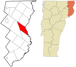
Victory is a town in Essex County, Vermont, United States. The population was 70 at the 2020 census. It is part of the Berlin, NH–VT Micropolitan Statistical Area. Victory was one of the last two towns in Vermont to be linked to the electric grid, in 1963.

<span class="mw-page-title-main">Richford, Vermont</span> Town in Vermont, United States

Richford is a town in Franklin County, Vermont, United States, located along the Canada–United States border. The population was 2,346 at the 2020 census.

<span class="mw-page-title-main">Morristown, Vermont</span> Town in Vermont, United States

Morristown is a town in Lamoille County, Vermont, United States. As of the 2020 census, the population was 5,434. Morristown is the largest town by population in Lamoille County, and its central village of Morrisville serves as the county's main commercial center.

<span class="mw-page-title-main">Wolcott, Vermont</span> Town in Vermont, United States

Wolcott is a town in Lamoille County, Vermont, United States. The town was named for General Oliver Wolcott, a signer of the Declaration of Independence. The population was 1,670 at the 2020 census.

<span class="mw-page-title-main">Duxbury, Vermont</span> Town in Vermont, United States

Duxbury is a town in Washington County, Vermont, United States. The population was 1,413 at the 2020 census. It claims to be the only municipality in the United States that has an elected position of dogcatcher.

<span class="mw-page-title-main">Plymouth, Vermont</span> Town in Vermont, United States

Plymouth is a town in Windsor County, Vermont, United States. The population was 641 at the 2020 census. Calvin Coolidge, the 30th president of the United States, was born and raised in Plymouth and is buried there in the Plymouth Notch cemetery. The State of Vermont Division for Historic Preservation owns and maintains the Coolidge Homestead and the village of Plymouth Notch.

References

  1. "Profile for Ferdinand, Vermont". ePodunk . Retrieved May 9, 2010.
  2. "Census - Geography Profile: Ferdinand town, Essex County, Vermont". United States Census Bureau . Retrieved December 30, 2021.
  3. "Geographic Identifiers: 2010 Census Summary File 1 (G001): Ferdinand town, Essex County, Vermont". American Factfinder. U.S. Census Bureau. Archived from the original on February 13, 2020. Retrieved April 5, 2016.
  4. "U.S. Decennial Census". United States Census Bureau. Retrieved May 16, 2015.
  5. "U.S. Census website". United States Census Bureau . Retrieved January 31, 2008.