National Register of Historic Places listings in Bennington County, Vermont

Last updated

Location of Bennington County in Vermont Map of Vermont highlighting Bennington County.svg
Location of Bennington County in Vermont

This is a list of the National Register of Historic Places listings in Bennington County, Vermont.

Contents

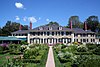
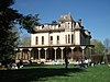
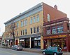
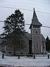
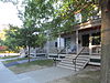
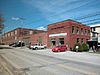
This is intended to be a complete list of the properties and districts on the National Register of Historic Places in Bennington County, Vermont, United States. Latitude and longitude coordinates are provided for many National Register properties and districts; these locations may be seen together in a map. [1]

There are 54 properties and districts listed on the National Register in the county.


    This National Park Service list is complete through NPS recent listings posted December 30, 2022. [2]

Contents: Counties in Vermont
Addison - Bennington - Caledonia - Chittenden - Essex - Franklin - Grand Isle - Lamoille - Orange - Orleans - Rutland - Washington - Windham - Windsor
Map all coordinates using: OpenStreetMap  
Download coordinates as: KML

Current listings

[3] Name on the Register [4] ImageDate listed [5] Location City or townDescription
1 Arlington Green Covered Bridge
Arlington Green Covered Bridge ARLINGTON GREEN COVERED BRIDGE.jpg
Arlington Green Covered Bridge
August 28, 1973
(#73000184)
Off VT 313 west of Arlington
43°06′16″N73°13′14″W / 43.104444°N 73.220556°W / 43.104444; -73.220556 (Arlington Green Covered Bridge)
Arlington
2 Arlington Village Historic District
Arlington Village Historic District ArlingtonVT MarbleSidewalk.jpg
Arlington Village Historic District
November 2, 1989
(#89001936)
Roughly Main St., School St., E. Arlington Rd., and Battenkill Dr.
43°04′22″N73°09′23″W / 43.072778°N 73.156389°W / 43.072778; -73.156389 (Arlington Village Historic District)
Arlington
3 Bennington Battle Monument
Bennington Battle Monument CW memorial Bennington VT.jpg
Bennington Battle Monument
March 31, 1971
(#71000054)
Monument Circle
42°53′20″N73°13′00″W / 42.888889°N 73.216667°W / 42.888889; -73.216667 (Bennington Battle Monument)
Bennington
4 Bennington College Historic District
Bennington College Historic District Bennington College.jpg
Bennington College Historic District
December 28, 2022
(#100008509)
1 College Dr.
42°55′12″N73°14′07″W / 42.9201°N 73.2353°W / 42.9201; -73.2353 (Bennington College Historic District)
Bennington
5 Bennington Falls Covered Bridge
Bennington Falls Covered Bridge Paper Mill Bridge, Bennington, Vermont.jpg
Bennington Falls Covered Bridge
August 28, 1973
(#73000185)
Northwest of Bennington off VT 67A
42°54′46″N73°14′03″W / 42.912778°N 73.234167°W / 42.912778; -73.234167 (Bennington Falls Covered Bridge)
Bennington Also known as the Paper Mill Bridge
6 Bennington Fish Hatchery
Bennington Fish Hatchery BenningtonVT Hatchery2.jpg
Bennington Fish Hatchery
April 21, 1994
(#94000376)
South Stream Rd.
42°51′09″N73°10′20″W / 42.852582°N 73.172306°W / 42.852582; -73.172306 (Bennington Fish Hatchery)
Bennington
7 Bennington High School
Bennington High School Bennington High School, Bennington VT.jpg
Bennington High School
August 26, 2005
(#05000948)
650 Main St.
42°52′43″N73°11′24″W / 42.8785°N 73.1899°W / 42.8785; -73.1899 (Bennington High School)
Bennington Bennington's 1913 high school building
8 Bennington Post Office
Bennington Post Office Old Bennington, VT, post office.jpg
Bennington Post Office
December 12, 1976
(#76000137)
118 South St.
42°52′39″N73°11′49″W / 42.877564°N 73.1969°W / 42.877564; -73.1969 (Bennington Post Office)
Bennington Former post office, now houses the police department
9 Bennington Railroad Station
Bennington Railroad Station Old Bennington, VT, train station.jpg
Bennington Railroad Station
November 9, 1988
(#88001301)
Depot and River Sts.
42°52′54″N73°11′58″W / 42.881667°N 73.199444°W / 42.881667; -73.199444 (Bennington Railroad Station)
Bennington
10 W. H. Bradford Hook and Ladder Fire House
W. H. Bradford Hook and Ladder Fire House W H Bradford Hook and Ladder Fire House, Bennington VT.jpg
W. H. Bradford Hook and Ladder Fire House
October 28, 1999
(#99001295)
212 Safford St.
42°52′52″N73°11′19″W / 42.881111°N 73.188611°W / 42.881111; -73.188611 (W. H. Bradford Hook and Ladder Fire House)
Bennington
11 William C. Bull House March 28, 2022
(#100007531)
219 Pleasant St.
42°52′45″N73°11′33″W / 42.8791°N 73.1925°W / 42.8791; -73.1925 (William C. Bull House)
Bennington
12 E. J. Bullock Block September 21, 2021
(#100007005)
7012 Main St.
42°46′20″N72°56′54″W / 42.7722°N 72.9484°W / 42.7722; -72.9484 (E. J. Bullock Block)
Readsboro
13 Carrigan Lane Historic District
Carrigan Lane Historic District BenningtonVT CarriganLaneHD.jpg
Carrigan Lane Historic District
September 3, 1998
(#98001152)
Roughly along Carrigan Ln., from Division St. to Safford St.
42°52′59″N73°11′19″W / 42.883056°N 73.188611°W / 42.883056; -73.188611 (Carrigan Lane Historic District)
Bennington
14 Center Shaftsbury Historic District
Center Shaftsbury Historic District Center Shaftsbury, Vermont.jpg
Center Shaftsbury Historic District
November 9, 1988
(#88002052)
VT 7A
42°59′05″N73°12′42″W / 42.984722°N 73.211667°W / 42.984722; -73.211667 (Center Shaftsbury Historic District)
Shaftsbury
15 Dorset Village Historic District
Dorset Village Historic District Dorset Village, Vermont.jpg
Dorset Village Historic District
April 18, 1985
(#85000868)
Roughly bounded by Main and Church Sts. and Dorset Hollow Rd.; also the junction of Church St. and West Rd.
43°15′26″N73°06′15″W / 43.257222°N 73.104167°W / 43.257222; -73.104167 (Dorset Village Historic District)
Dorset Second set of boundaries represents a boundary increase
16 Downtown Bennington Historic District
Downtown Bennington Historic District Buildings on South Main Street, downtown Bennington, VT.jpg
Downtown Bennington Historic District
April 1, 1980
(#80000327)
U.S. Route 7 and VT 9; also North, Main, and Silver Sts.
42°52′43″N73°11′51″W / 42.878611°N 73.1975°W / 42.878611; -73.1975 (Downtown Bennington Historic District)
Bennington Second set of boundaries represents a boundary increase
17 East Arlington Village Historic District
East Arlington Village Historic District Church in East Arlington, Vermont.jpg
East Arlington Village Historic District
July 5, 1996
(#96000689)
Roughly bounded by Old Mill, Ice Pond, E. Arlington, and Warm Brook Rds., Maple and Pleasnt Sts., and the Lane
43°03′42″N73°08′40″W / 43.061667°N 73.144444°W / 43.061667; -73.144444 (East Arlington Village Historic District)
Arlington
18 Equinox House Historic District
Equinox House Historic District Equinox Hotel Manchester Village Vermont.jpg
Equinox House Historic District
November 21, 1972
(#72000107)
Main and Union Sts.
43°09′43″N73°04′25″W / 43.161944°N 73.073611°W / 43.161944; -73.073611 (Equinox House Historic District)
Manchester Boundary increased June 3, 1980
19 First Congregational Church of Bennington
First Congregational Church of Bennington FirstCongregationalChurchofBennington.jpg
First Congregational Church of Bennington
April 24, 1973
(#73000186)
Monument Ave.
42°53′00″N73°12′48″W / 42.883333°N 73.213333°W / 42.883333; -73.213333 (First Congregational Church of Bennington)
Bennington
20 Robert Frost Farm
Robert Frost Farm FrostFarmSouthShaftsburyVT.jpg
Robert Frost Farm
May 23, 1968
(#68000047)
0.25 mi (0.40 km) west of U.S. Route 7 on Buck Hill Rd.
42°56′28″N73°11′42″W / 42.941111°N 73.195°W / 42.941111; -73.195 (Robert Frost Farm)
South Shaftsbury 
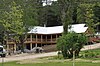
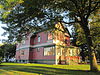
Residence of poet Robert Frost between 1929 and 1938. Designated a National Historic Landmark in 1968, the Park Service withdrew the landmark designation in 1986. [6]
21 Furnace Grove Historic District
Furnace Grove Historic District BenningtonVT FurnaceGroveHD 1.jpg
Furnace Grove Historic District
June 27, 1997
(#97000646)
VT 9, 1 mi (1.6 km) east of the junction of VT 9 and Burgess Rd.
42°53′06″N73°09′24″W / 42.885°N 73.156667°W / 42.885; -73.156667 (Furnace Grove Historic District)
Bennington
22 Gov. Jonas Galusha Homestead
Gov. Jonas Galusha Homestead Gov. Jonas Galusha Homestead.jpg
Gov. Jonas Galusha Homestead
November 30, 1979
(#79000217)
3817 Vermont Route 7A
42°59′17″N73°12′24″W / 42.988117°N 73.206772°W / 42.988117; -73.206772 (Gov. Jonas Galusha Homestead)
Center Shaftsbury
23 Zera Hard House
Zera Hard House ManchesterVT ZeraHardHouse Cape.jpg
Zera Hard House
November 9, 1988
(#88002230)
River Rd.
43°07′49″N73°04′56″W / 43.130278°N 73.082222°W / 43.130278; -73.082222 (Zera Hard House)
Manchester
24 Henry Covered Bridge
Henry Covered Bridge Burt Henry Covered Bridge.jpg
Henry Covered Bridge
August 28, 1973
(#73000187)
Northwest of Bennington off VT 67A
42°54′45″N73°15′18″W / 42.9125°N 73.255°W / 42.9125; -73.255 (Henry Covered Bridge)
Bennington
25 William Henry House
William Henry House Henry House.jpg
William Henry House
November 9, 1988
(#88001302)
River Rd.
42°54′30″N73°15′20″W / 42.9083°N 73.2556°W / 42.9083; -73.2556 (William Henry House)
Bennington
26 Hildene
Hildene Hildene manchester vermont 2006.jpg
Hildene
October 28, 1977
(#77000095)
820 Hildene Rd.
43°08′13″N73°04′25″W / 43.1369°N 73.0736°W / 43.1369; -73.0736 (Hildene)
Manchester
27 Holden-Leonard Mill Complex
Holden-Leonard Mill Complex Holden-Leonard Mill Complex, Bennington VT.jpg
Holden-Leonard Mill Complex
November 14, 1988
(#88002085)
160 Benmont Ave.
42°53′06″N73°12′13″W / 42.885°N 73.2036°W / 42.885; -73.2036 (Holden-Leonard Mill Complex)
Bennington
28 Holden-Leonard Workers Housing Historic District
Holden-Leonard Workers Housing Historic District 124-150 Benmont Avenue in the Holden Leonard Workers Housing District, Bennington VT.jpg
Holden-Leonard Workers Housing Historic District
May 19, 2011
(#11000296)
121-139, 124-150 Benmont Ave. & 105-115, 117-123 Holden St.
42°53′00″N73°12′07″W / 42.8833°N 73.2019°W / 42.8833; -73.2019 (Holden-Leonard Workers Housing Historic District)
Bennington
29 Jenks Tavern
Jenks Tavern RupertVT JenksTavern.jpg
Jenks Tavern
March 17, 1994
(#94000191)
Junction of Dorset West Rd. and VT 315
43°16′20″N73°07′35″W / 43.2722°N 73.1264°W / 43.2722; -73.1264 (Jenks Tavern)
Rupert
30 Johnny Seesaw's Historic District
Johnny Seesaw's Historic District PeruVT JohnnySeesaws.jpg
Johnny Seesaw's Historic District
July 18, 2008
(#08000686)
3574 VT 11
43°12′58″N72°55′28″W / 43.2161°N 72.9244°W / 43.2161; -72.9244 (Johnny Seesaw's Historic District)
Peru
31 Kent Neighborhood Historic District
Kent Neighborhood Historic District DorsetVT KentCorner KentTavern.jpg
Kent Neighborhood Historic District
July 14, 1978
(#78003203)
South of Dorset at Dorset West and Nichols Hill Rds.
43°14′22″N73°05′54″W / 43.2394°N 73.0983°W / 43.2394; -73.0983 (Kent Neighborhood Historic District)
Dorset
32 Amos Lawrence House
Amos Lawrence House ManchesterVT AmosLawrenceHouse.jpg
Amos Lawrence House
May 21, 1985
(#85001245)
Richville Rd.
43°09′55″N73°03′11″W / 43.1653°N 73.0531°W / 43.1653; -73.0531 (Amos Lawrence House)
Manchester
33 Manchester Village Historic District
Manchester Village Historic District Main Street, Manchester, Vermont.jpg
Manchester Village Historic District
January 26, 1984
(#84003438)
U.S. Route 7A, Union St., and Taconic Ave.
43°09′38″N73°04′22″W / 43.1606°N 73.0728°W / 43.1606; -73.0728 (Manchester Village Historic District)
Manchester
34 Manley-Lefevre House
Manley-Lefevre House DorsetVT MarbleHouse1.jpg
Manley-Lefevre House
January 26, 1990
(#89002324)
Dorset West Rd., Town Highway 1
43°13′36″N73°05′13″W / 43.2267°N 73.0869°W / 43.2267; -73.0869 (Manley-Lefevre House)
Dorset
35 David Mathews House
David Mathews House NY VT House.JPG
David Mathews House
September 10, 1979
(#79000274)
VT 67
42°56′27″N73°16′28″W / 42.9408°N 73.2744°W / 42.9408; -73.2744 (David Mathews House)
Shaftsbury Extends into Rensselaer County, New York; also known as the State Line House.
36 Munro-Hawkins House
Munro-Hawkins House Munro-Hawkins House.jpg
Munro-Hawkins House
May 17, 1973
(#73000188)
0.5 mi (0.80 km) south of Shaftsbury Center on Vermont Route 7A
42°57′24″N73°12′31″W / 42.9567°N 73.2086°W / 42.9567; -73.2086 (Munro-Hawkins House)
Shaftsbury Center
37 North Bennington Depot
North Bennington Depot North Bennington Depot Vermont.jpeg
North Bennington Depot
April 11, 1973
(#73000189)
Buckley Rd. and Depot St. at the Vermont Railway tracks
42°55′56″N73°14′32″W / 42.9323°N 73.2422°W / 42.9323; -73.2422 (North Bennington Depot)
North Bennington
38 North Bennington Historic District
North Bennington Historic District North Bennington, Vermont.jpg
North Bennington Historic District
August 29, 1980
(#80000328)
VT 67 and VT 67A
42°55′48″N73°14′35″W / 42.93°N 73.2431°W / 42.93; -73.2431 (North Bennington Historic District)
North Bennington
39 Julius and Sophia Norton House February 23, 2021
(#100006180)
300 Pleasant St.
42°52′44″N73°11′34″W / 42.879°N 73.1929°W / 42.879; -73.1929 (Julius and Sophia Norton House)
Bennington
40 Old Bennington Historic District
Old Bennington Historic District First Congregational Church of Bennington - 1804.jpg
Old Bennington Historic District
October 4, 1984
(#84000030)
Roughly bounded by the former Rutland Railway line, Monument Ave. and Circle, West Rd., Seminary Lane, and Elm and Fairview Sts.
42°53′01″N73°12′45″W / 42.8836°N 73.2125°W / 42.8836; -73.2125 (Old Bennington Historic District)
Bennington
41 The Orchards
The Orchards Everett Mansion at Southern Vermont College.jpg
The Orchards
April 24, 2000
(#00000384)
982 Mansion Dr.
42°52′08″N73°13′13″W / 42.8689°N 73.2203°W / 42.8689; -73.2203 (The Orchards)
Bennington Now the campus of Southern Vermont College
42 Park-McCullough House
Park-McCullough House ParkMcCulloughHouse.jpg
Park-McCullough House
October 26, 1972
(#72000090)
Southwestern corner of West and Park Sts.
42°55′42″N73°14′49″W / 42.9283°N 73.2469°W / 42.9283; -73.2469 (Park-McCullough House)
North Bennington
43 Pratt-McDaniels-LaFlamme House
Pratt-McDaniels-LaFlamme House BenningtonVT PrattMcDanielsLaFlammeHouse.jpg
Pratt-McDaniels-LaFlamme House
July 11, 2002
(#02000777)
501-507 South St.
42°52′21″N73°11′50″W / 42.8725°N 73.1972°W / 42.8725; -73.1972 (Pratt-McDaniels-LaFlamme House)
Bennington
44 Ritchie Block
Ritchie Block Ritchie Block, Bennington, VT.jpg
Ritchie Block
November 6, 1986
(#86003060)
465-473 Main St.
42°52′39″N73°11′44″W / 42.8775°N 73.1956°W / 42.8775; -73.1956 (Ritchie Block)
Bennington
45 Rupert Village Historic District
Rupert Village Historic District Church in Rupert, Vermont.jpg
Rupert Village Historic District
January 4, 2022
(#100007308)
VT 153, Rupert Mountain, West Pawlet, and Youlin Rds.
43°15′36″N73°13′22″W / 43.2599°N 73.2228°W / 43.2599; -73.2228 (Rupert Village Historic District)
Rupert
46 School Street Duplexes
School Street Duplexes School Street Duplexes, Bennington VT.jpg
School Street Duplexes
March 13, 2007
(#07000162)
343-345 and 347-349 School St.
42°53′09″N73°11′40″W / 42.885833°N 73.194444°W / 42.885833; -73.194444 (School Street Duplexes)
Bennington
47 Silk Covered Bridge
Silk Covered Bridge SilkCoveredBridge.jpg
Silk Covered Bridge
August 28, 1973
(#73000190)
Northwest of Bennington off VT 67A
42°54′34″N73°13′33″W / 42.909444°N 73.225833°W / 42.909444; -73.225833 (Silk Covered Bridge)
Bennington
48 Frederick Squire House
Frederick Squire House Frederick Squire House, Bennington VT.jpg
Frederick Squire House
July 30, 1992
(#92000964)
185 North St.
42°52′53″N73°11′48″W / 42.881472°N 73.196735°W / 42.881472; -73.196735 (Frederick Squire House)
Bennington
49 Tudor House
Tudor House StamfordVT TudorHouse.jpg
Tudor House
September 10, 1979
(#79000218)
VT 8
42°45′05″N73°04′11″W / 42.751389°N 73.069722°W / 42.751389; -73.069722 (Tudor House)
Stamford
50 Wait Block
Wait Block Main Street, Manchester, Vermont.jpg
Wait Block
November 7, 1996
(#96001327)
Near the junction of Main and Bonnet Sts. in Manchester Center
43°10′36″N73°03′24″W / 43.176667°N 73.056667°W / 43.176667; -73.056667 (Wait Block)
Manchester
51 H.C. White Company Mill Complex
H.C. White Company Mill Complex The original White offices from the west; Building 2 at left.jpg
H.C. White Company Mill Complex
January 11, 2017
(#100000515)
940 Water St.
42°54′56″N73°14′48″W / 42.915538°N 73.246614°W / 42.915538; -73.246614 (H.C. White Company Mill Complex)
North Bennington
52 Cora B. Whitney School
Cora B. Whitney School Cora B Whitney School, Bennington VT.jpg
Cora B. Whitney School
November 19, 2001
(#01001237)
814 Gage St.
42°52′53″N73°10′59″W / 42.881389°N 73.183056°W / 42.881389; -73.183056 (Cora B. Whitney School)
Bennington
53 Wilson House
Wilson House DorsetVT WilsonHouse.jpg
Wilson House
December 13, 1995
(#95001427)
Junction of Village St. and Mad Tom Rd.
43°14′22″N73°00′33″W / 43.239444°N 73.009167°W / 43.239444; -73.009167 (Wilson House)
East Dorset
54 Yester House
Yester House ManchesterVT SVAC YesterHouse.jpg
Yester House
November 10, 1988
(#88002051)
West Rd.
43°10′39″N73°04′39″W / 43.1775°N 73.0775°W / 43.1775; -73.0775 (Yester House)
Manchester Now the Southern Vermont Arts Center

See also

Related Research Articles

<span class="mw-page-title-main">National Register of Historic Places listings in Hampshire County, Massachusetts</span>

This is a list of properties on the National Register of Historic Places in Hampshire County, Massachusetts.

<span class="mw-page-title-main">National Register of Historic Places listings in Nantucket County, Massachusetts</span>

This is a list of the National Register of Historic Places listings in Nantucket County, Massachusetts.

This is a list of the National Register of Historic Places listings in Addison County, Vermont.

This is a list of the National Register of Historic Places listings in Chittenden County, Vermont.

This is a list of the National Register of Historic Places listings in Rutland County, Vermont.

This is a list of the National Register of Historic Places listings in Orange County, Vermont.

This is a list of the National Register of Historic Places listings in Orleans County, Vermont.

This is a list of the National Register of Historic Places listings in Franklin County, Vermont.

This is a list of the National Register of Historic Places listings in Grand Isle County, Vermont.

This is a list of the National Register of Historic Places listings in Essex County, Vermont.

This is a list of the National Register of Historic Places listings in Lamoille County, Vermont.

This is a list of the National Register of Historic Places listings in Caledonia County, Vermont.

This is a list of the National Register of Historic Places listings in Windsor County, Vermont.

This is a list of the National Register of Historic Places listings in Washington County, Vermont.

This is a list of the National Register of Historic Places listings in Windham County, Vermont.

<span class="mw-page-title-main">National Register of Historic Places listings in Nevada County, California</span>

This is a list of the National Register of Historic Places listings in Nevada County, California.

<span class="mw-page-title-main">National Register of Historic Places listings in Inyo County, California</span>

This is a list of the National Register of Historic Places listings in Inyo County, California.

<span class="mw-page-title-main">National Register of Historic Places listings in Marion County, Missouri</span>

The following properties are listed on the National Register of Historic Places in Marion County, Missouri.

<span class="mw-page-title-main">National Register of Historic Places listings in Wright County, Missouri</span>

This is a list of the National Register of Historic Places listings in Wright County, Missouri.

<span class="mw-page-title-main">National Register of Historic Places listings in Linn County, Missouri</span>

This is a list of the National Register of Historic Places listings in Linn County, Missouri.

References

  1. The latitude and longitude information provided in this table was derived originally from the National Register Information System, which has been found to be fairly accurate for about 99% of listings. Some locations in this table may have been corrected to current GPS standards.
  2. National Park Service, United States Department of the Interior, "National Register of Historic Places: Weekly List Actions", retrieved December 30, 2022.
  3. Numbers represent an alphabetical ordering by significant words. Various colorings, defined here, differentiate National Historic Landmarks and historic districts from other NRHP buildings, structures, sites or objects.
  4. "National Register Information System". National Register of Historic Places . National Park Service. April 24, 2008.
  5. The eight-digit number below each date is the number assigned to each location in the National Register Information System database, which can be viewed by clicking the number.
  6. "Withdrawal of National Historic Landmark Designation: Robert Frost Farm". National Park Service. Retrieved 2012-03-12.