
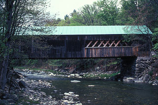
The Burt Henry Covered Bridge, also known as the Henry Covered Bridge or just the Henry Bridge, is a covered bridge that spans the Walloomsac River near Bennington, Vermont. A Town lattice truss bridge, it carries River Road, just south of the village of North Bennington. Originally built about 1840, it was listed on the National Register of Historic Places in 1973 as Bennington County's oldest covered bridge. It was rebuilt in 1989 by the Vermont Agency of Transportation.

The Brown Covered Bridge is a wooden covered bridge in Shrewsbury, Vermont. Located in the northwestern part of the town, it carries Upper Cold River Road over the Cold River. It was closed to vehicular traffic in 2011 due to damage from Hurricane Irene and reopened on July 5, 2016. Built in 1880 by noted Vermont bridgewright Nichols M. Powers, it was designated a National Historic Landmark in 2014, cited as one of the finest and least-altered examples of a Town lattice truss covered bridge in the United States.

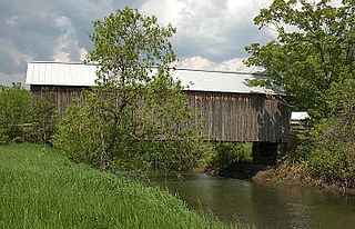
The Worrall Covered Bridge, also known as the Woralls Bridge or Worral Bridge is a wooden covered bridge carrying Williams Road across the Williams River in Rockingham, Vermont, United States. Built about 1870, it is the only surviving 19th-century covered bridge in the town, after the Hall Covered Bridge collapsed in 1980 and was replaced in 1982, and the Bartonsville Covered Bridge was washed away by Hurricane Irene in 2011 and replaced in 2012-2013. The bridge was listed on the National Register of Historic Places in 1973. The bridge was damaged by the flooding on July 10, 2023, and its fate has not yet been decided.

The Batten Kill, Battenkill, or Battenkill River is a 59.4-mile-long (95.6 km) river rising in Vermont that flows into New York and is a tributary of the Hudson River. It is the longest Hudson tributary on that river's east. As "kill" means a creek, the name "Battenkill River" is pleonastic.

The Silk Covered Bridge is a covered bridge, carrying Silk Road across the Walloomsac River between downtown Bennington, Vermont and the village of North Bennington, United States. A Town lattice truss bridge, it was built in 1840, and is one of three covered bridges across the river in fairly close proximity. It was added to the National Register of Historic Places in 1973.

Arlington is a census-designated place (CDP) in the towns of Arlington and Sunderland, Bennington County, Vermont, United States. The population was 1,213 at the 2010 census.

The Lower Cox Brook Covered Bridge is a wooden covered bridge that crosses Cox Brook in Northfield, Vermont on Cox Brook Road. Built in 1872, it is one of five surviving 19th-century covered bridges in the town, in the only place in Vermont where two historic bridges are visible from each other. It was listed on the National Register of Historic Places in 1974.

The Upper Cox Brook Covered Bridge is a wooden covered bridge that crosses Cox Brook on Cox Brook Road in Northfield, Vermont. It is one of five surviving 19th-century covered bridges in the town, and one of three on the same road. It was listed on the National Register of Historic Places in 1974.

The Great Eddy Covered Bridge, also called the Big Eddy Covered Bridge or Waitsfield Covered Bridge, is a wooden covered bridge that crosses the Mad River in Waitsfield, Vermont on Bridge Street. Built in 1833, it is one of Vermont's oldest covered bridges. It was listed on the National Register of Historic Places in 1974.

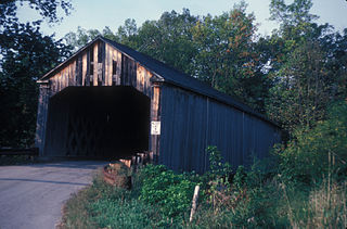
The Longley Covered Bridge, also known as the Harnois Covered Bridge, is a wooden covered bridge that crosses the Trout River in Montgomery, Vermont on Longley Bridge Road. Built in 1863, this Town lattice truss bridge is the oldest of a group of area bridges built by brothers Sheldon & Savannah Jewett. It was listed on the National Register of Historic Places in 1974. The bridge is closed to traffic, and has been bypassed by an adjacent temporary bridge.
The Williamsville Covered Bridge is a historic covered bridge, carrying Dover Road over the Rock River in Newfane, Vermont. Probably built in the 1870s, this Town lattice truss bridge is probably the oldest covered bridge in Windham County, and is the only one surviving in the town of Newfane. It was listed on the National Register of Historic Places in 1973.

The Dean Covered Bridge was a Town lattice truss covered bridge, carrying Union Street across Otter Creek in Brandon, Vermont. Built in 1840, it was one of Vermont's oldest covered bridges at the time of its destruction in 1986 by an arsonist. It was listed on the National Register of Historic Places, and was replaced by a modern steel and concrete bridge.
The Sanderson Covered Bridge is a historic covered bridge, which carries Pearl Street over Otter Creek in Brandon, Vermont. Built about 1840, it is one of Vermont's oldest covered bridges, and is the only remaining 19th century bridge in Brandon. It was listed on the National Register of Historic Places in 1974.

The Bowers Covered Bridge(akaBrownsville Bridge) is a historic covered bridge, carrying Bible Hill Road across Mill Brook in the Brownsville section of West Windsor, Vermont. Built in 1919, it has a laminated-arch deck covered by a post-and-beam superstructure, similar to Best's Covered Bridge, Windsor's other historic covered bridge. It was listed on the National Register of Historic Places in 1973. It was rebuilt after being swept off its foundation in 2011 by Hurricane Irene, but has been damaged by vehicle strikes several times since then, and is being considered for closure.

The Taftsville Covered Bridge is a timber-framed covered bridge which spans the Ottauquechee River in the Taftsville village of Woodstock, Vermont, in the United States. Built in 1836 and exhibiting no influence from patented bridge designs, it is among the oldest remaining covered bridges both in Vermont and the nation as a whole.

The Martin's Mill Covered Bridge is a wooden covered bridge spanning Lull's Brook on Martinsville Road in Hartland, Vermont. Built about 1880, it is one of two surviving 19th-century covered bridges in the town. It was listed on the National Register of Historic Places in 1973.
The Howe Covered Bridge is a historic covered bridge carrying Belknap Brook Road across the White River in Tunbridge, Vermont, just east of Vermont Route 110. Built in 1879, it is one of five surviving bridges in the town, one of the highest concentrations of covered bridges in the state. It was listed on the National Register of Historic Places in 1974.

The Mill Covered Bridge is a replica historic covered bridge carrying Spring Road across the First Branch White River in Tunbridge, Vermont. It was built in 2000, nearly replicating a previous structure built on the site in 1883 and lost due to ice damage. It is one of a high concentration of covered bridges in Tunbridge and Chelsea. The 1883 bridge was listed on the National Register of Historic Places in 1974.

The Woodstock Warren Through Truss Bridge was a historic iron bridge that carried Bridges Road across the Ottauquechee River in western Woodstock, Vermont. The bridge was built in 1925, and was a rare example of the state of a double-intersection Warren through truss. The bridge was swept away by flooding caused by Hurricane Irene in 2011; it was listed on the National Register of Historic Places in 1992.

The Hectorville Covered Bridge is a historic covered bridge in Montgomery, Vermont. Originally located on Gibou Road off Vermont Route 118 in central Montgomery, the bridge is currently (2016) in storage. It was built by Sheldon & Savannah Jewett, who are credited with building all of Montgomery's surviving 19th century covered bridges. It was listed on the National Register of Historic Places in 1974.


