
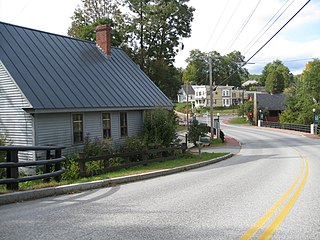
North Bennington is an incorporated village in the town of Bennington in Bennington County, Vermont, United States. The population was 1,716 at the 2020 census.
Bennington is a town in Bennington County, Vermont, in the United States. It is one of two shire towns of the county, the other being Manchester. As of the 2020 US Census, the population was 15,333. Bennington is the most populous town in southern Vermont, the third-largest town in Vermont and the sixth-largest municipality in the state including the cities of Burlington, Rutland, and South Burlington.

The David Mathews House, also known as the State Line House, is a historic house straddling the state line on New York State Route 67 and Vermont Route 67 in Hoosick, New York and Shaftsbury, Vermont. Built about 1800, it is an imposing brick example of Federal architecture. The building is the subject of a number of tales, some of dubious authenticity. It was listed on the National Register of Historic Places in 1979.

The East Andover Village Center Historic District encompasses the historic village center of East Andover, New Hampshire, United States. The 2.2-acre (0.89 ha) district includes a cemetery and three buildings: the Andover Congregational Church, the Highland Lake Grange Hall, and the East Andover Schoolhouse. It is located at the corner of New Hampshire Route 11 and Chase Hill Road. The district is unified by the appearance of the three buildings, and their styling, which is predominantly vernacular 19th century.

The Canaan Street Historic District encompasses the historic original town center of Canaan, New Hampshire. It is a basically linear district, running along Canaan Street roughly from Prospect Hill Road in the north to Moss Flower Lane in the south. The town flourished first as a stagecoach stop, and then as a resort colony in the late 19th century. The historic district was listed on the National Register of Historic Places in 1973. It included 60 contributing buildings.

The Jaffrey Center Historic District encompasses the traditional civic heart of the small town of Jaffrey, New Hampshire. The district lies to the west of the Jaffrey's main business district, extending along Main Street from Harkness Road to the Jaffrey Common, and along Thorndike Pond Road northward from Main Street. It includes the town's oldest civic buildings, and was its main center until the mills of East Jaffrey eclipsed it. The district was listed on the National Register of Historic Places in 1975.
The Enfield Village Historic District encompasses the historic 19th century village center of Enfield, New Hampshire. The district was listed on the National Register of Historic Places in 2010. Multiple buildings of the district were added to the New Hampshire State Register of Historic Places in 2012.

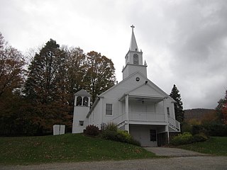
The Bennington Village Historic District of Bennington, New Hampshire encompasses the 19th-century center of the village. Growth of the village followed a typical pattern for rural New Hampshire towns, based in this case around the growth in the early 19th century of the paper industry, which continues to be a significant economic force in the community. The district is centered on the junctions of Main, Center, and School Streets with Bible Hill Road and Francestown Road. The district was listed on the National Register of Historic Places in 2010.

The Hancock Village Historic District encompasses the town center of Hancock, New Hampshire. It extends the length of Hancock's Main Street, from Pine Ridge Cemetery and the common to the west, and the junction of Bennington, Norway Hill, and Forest roads to the east. It then extends a short way up Bennington Road. The common was laid out in 1785, and the village developed nearby over the next 100+ years. The district was listed on the National Register of Historic Places in 1988.
The New Ipswich Center Village Historic District encompasses the historic center of the rural town of New Ipswich, New Hampshire. The center village is the town's most densely populated area, with a history dating to the town's founding in 1735. The district extends along Turnpike Road between King and Porter Roads, and southward in a roughly triangular shape, the southern point of which is at the junction of Main Street and Willard Road. The village includes a large number of residences, which were mainly agricultural at first, but also include a number of properties built as summer resort houses in the late 19th and early 20th centuries. It also includes most of the town's historic civic buildings, including its historic town hall, and the Barrett House, now a museum property owned by Historic New England. The district was listed on the National Register of Historic Places in 1991.

The Dorset Village Historic District encompasses a significant portion of the village center of Dorset, Vermont. Centered at the junction of Church Street, Kent Hill Road, and Vermont Route 30, the village was developed between the late 18th and early 20th centuries, and has a number of well-preserved unusual features, including sidewalks of marble from local quarries. The district was listed on the National Register of Historic Places in 1985, and was enlarged to the west in 1997.

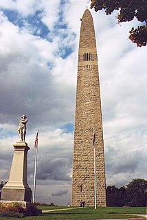
The Downtown Bennington Historic District encompasses the historic commercial heart of Bennington, Vermont. Centered on the junction of Main, South, and North Streets, it exhibits a variety of commercial architectural styles from the early 19th to mid-20th century. It was listed on the National Register of Historic Places in 1980, and was enlarged in 2008.
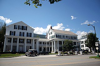
The Equinox House Historic District encompasses the historic center of the village of Manchester, Vermont. It includes a small group of civic and commercial buildings around the junction of Main Street and Union Street, with the luxury Equinox House hotel as its primary focus. The district, developed as a tourist destination in the late 1800s, was listed on the National Register of Historic Places in 1972, and enlarged in 1980. It is a small portion of the Manchester Village Historic District.

The Governor Jonas Galusha Homestead is a historic homestead at 3871 Vermont Route 7A in Shaftsbury Center, Vermont. Built in 1783 and enlarged in 1805, it is a well-preserved example of Federal period architecture. It was built by Jonas Galusha, Vermont's fifth governor and a leading politician and military figure of southern Vermont for many years. It is now home to the Shaftsbury Historical Society, and was listed on the National Register of Historic Places in 1979.

The North Bennington Depot is a historic railroad station at Depot Street and Buckley Road in North Bennington, Vermont. Built in 1880 as a passenger station, this Second Empire brick building is a surviving reminder of North Bennington's former importance as a major railroad hub in southwestern Vermont. It was listed on the National Register of Historic Places in 1973.
The Tinmouth Historic District encompasses a cluster of residential and civic buildings that form the center of the village Tinmouth Center in Tinmouth, Vermont. The district contains a collection of well-preserved buildings, that are reflective of life in a rural 19th-century village. The district was listed on the National Register of Historic Places in 1980.

The Weston Village Historic District encompasses the town center and principal village of Weston, Vermont. Centered on Farrar Park, which serves as the town green, it includes a diversity of architectural styles from the late 18th century to about 1935, and includes residential, civic, commercial, industrial and religious buildings. It was listed on the National Register of Historic Places in 1985.

The Thetford Center Historic District encompasses the village of Thetford Center in Thetford, Vermont. The village contains a well-preserved collection of early to mid-19th century architecture, a legacy of its period of greatest prosperity as an agricultural and industrial center. It was listed on the National Register of Historic Places in 1998.

The Stowe Village Historic District encompasses most of the village center of Stowe, Vermont. The village has since the 19th century been one of Vermont's major resort centers, and its center is architecturally reflective of this history, It was listed on the National Register of Historic Places in 1978.

The Peacham Corner Historic District encompasses much of the historic village center of Peacham, Vermont. The village's period of greatest growth and importance between the town's founding as a hill town in the late 18th century, and 1860, when significant development effectively ended. As a result, the village lacks Victorian features often found in other rural communities. The district was listed on the National Register of Historic Places in 2003.


