
The Haverhill Corner Historic District encompasses the early civic center of Haverhill, New Hampshire, United States. The district is focused on the junction of New Hampshire Route 10 and Court Street, which was historically a major through route. Court Street is flanked at the junction by a pair of large grassy common areas which are bounded by School Street and Route 10. Buildings, predominantly Federal in character and built in the late 18th and early 19th centuries, are arrayed around these commons, and historic buildings line Route 10 and Court Street for a short distance away from the commons. Prominent buildings in the district include the 1827 Federal-style First Congregational Church, the 1840 former courthouse that now houses the public library and local historical society, and the Romanesque Revival 1897 Haverhill Academy Junior High School building. The area declined in importance after the railroad bypassed it, resulting in the gradual relocation of civic functions to the Woodsville area. The district was listed on the National Register of Historic Places in 1987.

The Rochester Commercial and Industrial District encompasses the civic, commercial, and industrial heart of Rochester, New Hampshire. Oriented around the city's Central Square, the 6-acre (2.4 ha) district includes the city's major civic buildings, most of which are Classical Revival structures from the early 20th century, a number of commercial buildings dating as far back as the square's formation in the 1820s, and several late 19th-century industrial facilities. The district extends primarily along Main Street, from Bridge and Union Streets to Winter and Academy Streets, and includes properties extending along Wakefield and Hanson Streets, as well as other adjacent streets. The district was listed on the National Register of Historic Places in 1983.

The Sharon Historic District encompasses the historic civic center of Sharon, Connecticut. Centered around a mile-long town green are an array of public civic and religious buildings, as well as residences from the 18th to 20th centuries. The area south of the green on South Main Street is lined with country houses developed or improved in the late 19th and early 20th centuries, representing one of the highest concentrations of Colonial Revival estates in the state. The district was listed on the National Register of Historic Places in 1993.

The Brattleboro Downtown Historic District encompasses most of the central business district of the town of Brattleboro, Vermont. Extending along Main Street between Whetstone Brook and a junction with Pultney Road and Linden and Walnut Streets, this area includes many of the town's prominent civic and institutional buildings. The area's development took place primarily in the 19th century, with surviving buildings from both the 18th and early 20th centuries. The district was listed on the National Register of Historic Places in 1983, and was enlarged in 2004 to include Plaza Park and the Holstein Building on the south side of Whetstone Brook.

The Bennington Fish Hatchery, also known as the Bennington Fish Culture Station, is a state-operated fish hatchery at 110 Hatchery Road in Bennington, Vermont, USA. The station, the state's largest, produces a variety of trout, which are used to stock the state's water resources. Its facilities, dating to 1916, are listed on the National Register of Historic Places. The station has a visitors' center that is open daily.

Shaftsbury Center is an unincorporated village in the town of Shaftsbury in Bennington County, Vermont, United States. Located on Vermont Route 7A at West Mountain and Tunic Roads, near the town's geographic center, it was the town's main civic center through the middle of the 19th century. It is now a modest village with agricultural and tourist-oriented economic interests. Most of the village is listed on the National Register of Historic Places as the Center Shaftsbury Historic District.

The Dorset Village Historic District encompasses a significant portion of the village center of Dorset, Vermont. Centered at the junction of Church Street, Kent Hill Road, and Vermont Route 30, the village was developed between the late 18th and early 20th centuries, and has a number of well-preserved unusual features, including sidewalks of marble from local quarries. The district was listed on the National Register of Historic Places in 1985, and was enlarged to the west in 1997.
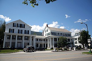
The Equinox House Historic District encompasses the historic center of the village of Manchester, Vermont. It includes a small group of civic and commercial buildings around the junction of Main Street and Union Street, with the luxury Equinox House hotel as its primary focus. The district, developed as a tourist destination in the late 1800s, was listed on the National Register of Historic Places in 1972, and enlarged in 1980. It is a small portion of the Manchester Village Historic District.

The Furnace Grove Historic District encompasses the remains of a historic 19th-century iron processing facility near Bennington, Vermont. Located on the north side of Vermont Route 9 east of the town center, its production peaked in the 1830s, and was afterward converted into a gentleman's farm. Surviving elements of its past include the remains of iron smelting furnaces, housing, and agricultural outbuildings. The district was listed on the National Register of Historic Places in 1997.
The Ritchie Block is a historic commercial building at 465-473 Main Street in downtown Bennington, Vermont. Built in 1895-96, it is a high quality example of Classical Revival architecture, with a distinctive pressed metal entablature. The building was listed on the National Register of Historic Places in 1986.

The Poultney Main Street Historic District encompasses the commercial and residential historic core of the village of Poultney, Vermont. Centered on Main Street and East Main Street, between College Avenue and St. Raphael's Catholic Church, the district includes a diversity of architectural styles, as well as civic, religious, and commercial functions spanning a period of more than 100 years. The district was listed on the National Register of Historic Places in 1988.

The Bethel Village Historic District encompasses the historic core of the village of Bethel in the town of Bethel, Vermont, USA. The L-shaped district extends along Main and Church Streets, including many of the village's commercial and civic buildings, as well as a significant number of 19th and early 20th-century residences. The district was listed on the National Register of Historic Places in 1976, and was slightly enlarged in 1990.

The Chelsea Village Historic District encompasses the historic village center of Chelsea, Vermont, the shire town of Orange County. Developed in the first half of the 19th century as a regional service and transportation hub, the village exhibits a significant number of Greek Revival buildings, augmented with primarily later civic and commercial buildings. It was listed on the National Register of Historic Places in 1983.

The Strafford Village Historic District encompasses the historic village center of Strafford, Vermont, United States. Founded in 1768, the village center was developed in the 1790s, and saw most of its growth before 1840, resulting in a fine assortment of predominantly Greek Revival buildings. Notable exceptions include the 1799 meetinghouse, and the Justin Smith Morrill Homestead, a fine example of Gothic Revival architecture built by native son Justin Smith Morrill. The district, centered on the town green at the junction of Morrill Highway and Brook Road, was listed on the National Register of Historic Places in 1974.
The Charlotte Center Historic District encompasses the historic 19th-century town center of Charlotte, Vermont. Settled c. 1790 and developed mainly in the mid-19th century, the village, stretched along Church Hill Road west of Hinesburg Road, retains a well-preserved 19th-century atmosphere of residential, civic, and commercial buildings. The district was listed on the National Register of Historic Places in 1984.

The Main Street–College Street Historic District encompasses a historically fashionable residential area of Burlington, Vermont. Principally located along Main and College Streets between South Winooski and South Williams Streets, the area was one of the city's most exclusive residential areas from the early 19th century to the early 20th century, and includes a diversity of high quality architecture from that period. It was listed on the National Register of Historic Places in 1988.
The St. Albans Historic District encompasses most of the historic commercial core of the city of St. Albans, Vermont. The district includes the historic town common, which acts as its focal center, and commercial and civic architecture dating from the early 19th to early 20th centuries. The district was listed on the National Register of Historic Places in 1980.

The Waitsfield Village Historic District encompasses much of the main village center of Waitsfield, Vermont. Extending along Vermont Route 100 on either side of Bridge Street, it is a well-preserved example of a 19th-century village, with only a few sympathetic 20th-century additions. It was listed on the National Register of Historic Places in 1983.

The Newport Downtown Historic District encompasses most of the historic downtown area of the city of Newport, Vermont. The city developed as a transit hub and tourist area in the second half of the 19th century, spurred by the construction of a railroad to the area. The district, roughly bounded by Third Street, Coventry Street, and Lake Memphremagog, was listed on the National Register of Historic Places in 2006.

The St. Johnsbury Main Street Historic District encompasses the historic civic and cultural center of the town of St. Johnsbury, Vermont. Organized along the town's Main Street, it includes high-quality architecture spanning the 19th and early 20th centuries, and includes the National Historic Landmark St. Johnsbury Athenaeum. Many of the district's buildings were designed by Lambert Packard, a prominent local architect. The district was listed on the National Register of Historic Places in 1975, and was enlarged slightly in 1976. It was subsumed into the larger St. Johnsbury Historic District in 1980.


