Plymouth, Vermont

Last updated

Plymouth, Vermont
PLYMOUTH HISTORIC DISTRICT.jpg
Union Christian Church (1840) in the Plymouth Historic District
Windsor County Vermont incorporated and unincorporated areas Plymouth highlighted.svg
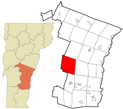
Location in Windsor County and the state of Vermont.
Usa edcp location map.svg
Red pog.svg
Plymouth, Vermont
Location in the United States
Coordinates: 43°31′54″N72°43′18″W / 43.53167°N 72.72167°W / 43.53167; -72.72167
Country United States
State Vermont
County Windsor
Area
  Total48.7 sq mi (126.1 km2)
  Land48.1 sq mi (124.6 km2)
  Water0.5 sq mi (1.4 km2)
Elevation
1,447 ft (420 m)
Population
 (2020)
  Total641
  Density13/sq mi (5.1/km2)
Time zone UTC-5 (Eastern (EST))
  Summer (DST) UTC-4 (EDT)
ZIP code
05056
Area code 802
FIPS code 50-56050 [1]
GNIS feature ID1462176 [2]

Plymouth is a town in Windsor County, Vermont, United States. The population was 641 at the 2020 census. [3] Calvin Coolidge, the 30th President of the United States, was born and raised in Plymouth and is buried there in the Plymouth Notch cemetery. The State of Vermont Division for Historic Preservation owns and maintains the Coolidge Homestead and the village of Plymouth Notch.

Contents

Geography

According to the United States Census Bureau, the town has a total area of 48.7 square miles (126.1 km2), of which 48.1 square miles (124.6 km2) is land and 0.54 square miles (1.4 km2), or 1.15%, is water. [4]

History

The old Coolidge store, run by John Calvin Coolidge, Sr., the President's father, housed the post office in the 1920s. John Coolidge's wife, Carrie, served as postmaster 1903–1917. [5] Coolidge's father also founded Plymouth Cheese, which continues to produce artisan cheese today.

Plymouth was one of thirteen Vermont towns isolated by flooding caused by Hurricane Irene in 2011. [6]

Demographics

Historical population
CensusPop.Note
1790 106
1800 497368.9%
1810 83467.8%
1820 1,11233.3%
1830 1,23711.2%
1840 1,41714.6%
1850 1,226−13.5%
1860 1,2522.1%
1870 1,2852.6%
1880 1,075−16.3%
1890 755−29.8%
1900 646−14.4%
1910 482−25.4%
1920 449−6.8%
1930 331−26.3%
1940 43230.5%
1950 348−19.4%
1960 308−11.5%
1970 283−8.1%
1980 40543.1%
1990 4408.6%
2000 55526.1%
2010 61911.5%
2020 6413.6%
U.S. Decennial Census [7]

As of the census [1] of 2000, there were 555 people, 251 households, and 168 families residing in the town. The population density was 11.5 people per square mile (4.4/km2). There were 773 housing units at an average density of 16.0 per square mile (6.2/km2). The racial makeup of the town was 99.28% White, 0.36% African American, and 0.36% from two or more races.

There were 251 households, out of which 23.5% had children under the age of 18 living with them, 55.8% were married couples living together, 5.2% had a female householder with no husband present, and 32.7% were non-families. 27.1% of all households were made up of individuals, and 10.0% had someone living alone who was 65 years of age or older. The average household size was 2.21 and the average family size was 2.59.

In the town, the population was spread out, with 18.0% under the age of 18, 2.9% from 18 to 24, 26.3% from 25 to 44, 33.2% from 45 to 64, and 19.6% who were 65 years of age or older. The median age was 47 years. For every 100 females, there were 110.2 males. For every 100 females age 18 and over, there were 107.8 males.

The median income for a household in the town was $43,438, and the median income for a family was $46,667. Males had a median income of $29,583 versus $27,917 for females. The per capita income for the town was $25,272. About 3.5% of families and 5.4% of the population were below the poverty line, including 3.7% of those under age 18 and 8.7% of those age 65 or over.

Related Research Articles

<span class="mw-page-title-main">Windsor County, Vermont</span> County in Vermont, United States

Windsor County is a county located in the U.S. state of Vermont. As of the 2020 census, the population was 57,753. The shire town is the town of Woodstock. The county's largest municipality is the town of Hartford.

<span class="mw-page-title-main">Grafton County, New Hampshire</span> County in New Hampshire, United States

Grafton County is a county in the U.S. state of New Hampshire. As of the 2020 census, the population was 91,118. Its county seat is the town of Haverhill. In 1972, the county courthouse and other offices were moved from Woodsville, a larger village within the town of Haverhill, to North Haverhill.

<span class="mw-page-title-main">Piermont, New Hampshire</span> Town in New Hampshire, United States

Piermont is a town in Grafton County, New Hampshire, United States. The population was 769 at the 2020 census. It is home to Camp Walt Whitman and Kingswood Camp for Boys.

<span class="mw-page-title-main">Cornish, New Hampshire</span> Town in New Hampshire, United States

Cornish is a town in Sullivan County, New Hampshire, United States. The population was 1,616 at the 2020 census. Cornish has four covered bridges. Each August, it is home to the Cornish Fair.

<span class="mw-page-title-main">Readsboro, Vermont</span> Town in Vermont, United States

Readsboro is a town in Bennington County, Vermont, United States. The town was named after John Reade, a landholder. The population was 702 at the 2020 census. The hamlet of Heartwellville is in the northern part of Readsboro, approximately 5 miles (8 km) north on Route 100 from the hamlet of Readsboro.

<span class="mw-page-title-main">Hinesburg, Vermont</span> Town in Vermont, United States

Hinesburg is a town in Chittenden County, Vermont, United States. The town was named for Abel Hine, town clerk. The population was 4,698 at the 2020 census.

<span class="mw-page-title-main">Randolph, Vermont</span> Town in Vermont, United States

Randolph is a town in Orange County, Vermont, United States. The population was 4,774 at the 2020 census, making Randolph the largest town in Orange County. The town is a commercial center for many of the smaller, rural farming communities that surround it.

<span class="mw-page-title-main">Andover, Vermont</span> Town in Vermont, United States

Andover is a town in Windsor County, Vermont, United States. The population was 568 at the 2020 census.

<span class="mw-page-title-main">Baltimore, Vermont</span> Town in Vermont, United States

Baltimore is a town in Windsor County, Vermont, United States. The population was 229 at the 2020 census.

<span class="mw-page-title-main">Bridgewater, Vermont</span> Town in Vermont, United States

Bridgewater is a town in Windsor County, Vermont, United States. The population was 903 at the 2020 census. Bridgewater contains the hamlets of Bridgewater Village, Bridgewater Corners, West Bridgewater, and Bridgewater Center.

<span class="mw-page-title-main">Reading, Vermont</span> Town in Vermont, United States

Reading is a town in Windsor County, Vermont, United States. The population was 687 at the 2020 census.

<span class="mw-page-title-main">Rochester, Vermont</span> Town in Vermont

Rochester is a town in Windsor County, Vermont, United States. The population was 1,099 at the 2020 census. The central village is delineated as the Rochester census-designated place.

<span class="mw-page-title-main">Royalton, Vermont</span> Town in Vermont, United States

Royalton is a town in Windsor County, Vermont, United States. The population was 2,750 at the 2020 census. It includes the villages of Royalton, South Royalton, and North Royalton. Vermont Law School, the state's only accredited law school, is located in South Royalton.

<span class="mw-page-title-main">Sharon, Vermont</span> Town in Vermont, United States

Sharon is a town in Windsor County, Vermont, United States. It had a population of 1,560 at the 2020 census.

<span class="mw-page-title-main">Stockbridge, Vermont</span> Town in Vermont, United States

Stockbridge is a town in Windsor County, Vermont, United States, which contains the village of Gaysville. The population was 718 at the 2020 census. Stockbridge was one of thirteen Vermont towns isolated by flooding caused by Hurricane Irene in 2011.

<span class="mw-page-title-main">West Windsor, Vermont</span> Town in Vermont, United States

West Windsor is a town in Windsor County, Vermont, United States. The population was 1,344 at the 2020 census. It was known for its Ascutney Mountain Resort, which closed in 2010 and was bought by its citizens in 2015.

<span class="mw-page-title-main">Weston, Vermont</span> Town in Vermont, United States

Weston is a town in Windsor County, Vermont, United States. The population was 623 at the 2020 census. Home to the Weston Playhouse Theatre Company, it includes the villages of Weston and The Island.

<span class="mw-page-title-main">Windsor, Vermont</span> Town in Vermont, United States

Windsor is a town in Windsor County, Vermont, United States. As the "Birthplace of Vermont", the town is where the Constitution of Vermont was adopted in 1777, thus marking the founding of the Vermont Republic, a sovereign state until 1791, when Vermont joined the United States. Over much of its history, Windsor was home to a variety of manufacturing enterprises. Its population was 3,559 at the 2020 census.

<span class="mw-page-title-main">Cambridge, Vermont</span> Town in Vermont, United States

Cambridge is a town in Lamoille County, Vermont, United States. The population was 3,839 at the 2020 United States Census. Cambridge includes the villages of Jeffersonville and Cambridge.

<span class="mw-page-title-main">Ludlow (town), Vermont</span> Town in Vermont, United States

Ludlow is a town in Windsor County, Vermont, United States. The population was 2,172 at the 2020 census. Ludlow is the home of Okemo Mountain, a popular ski resort. Before becoming a ski destination, Ludlow was originally a mill town, and was the home of a General Electric plant until 1977. It was named after Ludlow, Massachusetts which is less than 100 miles away. There is also a village of Ludlow in the town.

References

  1. 1 2 "U.S. Census website". United States Census Bureau . Retrieved January 31, 2008.
  2. "US Board on Geographic Names". United States Geological Survey. October 25, 2007. Retrieved January 31, 2008.
  3. "Census - Geography Profile: Plymouth town, Windsor County, Vermont". United States Census Bureau . Retrieved January 4, 2022.
  4. "Geographic Identifiers: 2010 Demographic Profile Data (G001): Plymouth town, Windsor County, Vermont". United States Census Bureau . Retrieved July 31, 2012.
  5. Bruns, James H. (1998). Great American Post Offices, pp 122-123. New York: John Wiley & Sons Inc. ISBN   0-471-14388-X. The book's front cover has a photograph showing the President and other residents on the front porch of the post office.
  6. Floodwaters From Storm Isolate 13 Vermont Towns, The New York Times
  7. "U.S. Decennial Census". United States Census Bureau. Retrieved May 16, 2015.