Brownsville, Vermont

Last updated

Brownsville, Vermont
Brownsville VT View.jpg
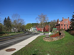
Brownsville, VT looking west along Route 44
Windsor County Vermont incorporated and unincorporated areas West Windsor highlighted.svg
Location in Windsor County and the state of Vermont.
Usa edcp location map.svg
Red pog.svg
Brownsville, Vermont
Location in the United States
Coordinates: 43°28′07″N72°28′15″W / 43.46861°N 72.47083°W / 43.46861; -72.47083
Country United States
State Vermont
County Windsor
Elevation
[1]
682 ft (208 m)
Time zone UTC-5 (Eastern (EST))
  Summer (DST) UTC-4 (EDT)
ZIP code
05037
Area code 802
GNIS feature ID1456613 [1]
Website www.westwindsorvt.govoffice2.com

Brownsville is an unincorporated community in West Windsor, Vermont, United States. Located on Vermont Route 44, the village houses a number of administrative offices for the town of West Windsor.

Contents

History

The village derives its name from two settlers, John and Briant Brown. The West Windsor Historical Society is in Brownsville and has a wealth of information on the sheep farms and industries that sustained the early residents.[ citation needed ]

Just east of Brownsville is the entrance to Ascutney Mountain Resort, which used to be one of the major ski areas in the state, until it closed for good in 2010 and their ski lifts were sold in August 2014. In 2015, Brownsville bought the failed ski area, working with the state of Vermont and the nonprofit Trust for Public Land. [2]

Geography

Slightly south and west of Brownsville is the 656-acre (2.65 km2) Little Ascutney Wildlife Management Area, [3] a state owned conservation area hosting wildlife such as white-tailed deer, fisher, coyotes, bobcats, beaver and otter.

Covered Bridges

Three of Vermont's covered bridges are nearby – Best's Bridge near Churchill Road and Bowers Bridge, both of which are listed in the National Register of Historic Places. The Twigg bridge on Yale Road was moved to its location by a developer and was heavily damaged by wind in 2002. The flooding caused by tropical storm Irene in 2011 damaged several bridges such as the Bowers Bridge. [4]

Government

Notes

  1. 1 2 U.S. Geological Survey Geographic Names Information System: Brownsville, Vermont. Retrieved on 07-04-2019.
  2. Goodman, David (February 1, 2022). "A Town That Saved a Mountain, and a Mountain That Saved a Town". The New York Times. ISSN   0362-4331 . Retrieved February 2, 2022.
  3. Little Ascutney Wildlife Management Area
  4. "Irene's silver lining: Vermont rediscovers its bridges". NBC News. October 10, 2011. Archived from the original on November 23, 2020. Retrieved March 28, 2024.