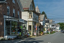
Chester, Vermont | |
---|---|
Coordinates: 43°17′17″N72°36′54″W / 43.28806°N 72.61500°W | |
Country | United States |
State | Vermont |
County | Windsor |
Communities |
|
Area | |
• Total | 55.9 sq mi (144.9 km2) |
• Land | 55.7 sq mi (144.2 km2) |
• Water | 0.3 sq mi (0.7 km2) |
Elevation | 823 ft (251 m) |
Population (2020) | |
• Total | 3,005 |
• Density | 54/sq mi (21/km2) |
Time zone | UTC-5 (Eastern (EST)) |
• Summer (DST) | UTC-4 (EDT) |
ZIP codes | 05143-05144 |
Area code | 802 |
FIPS code | 50-13675 [1] |
GNIS feature ID | 1462070 [2] |
Website | chestervt |
Chester is a town in Windsor County, Vermont, United States. The population was 3,005 at the 2020 census. [3]
The town was originally chartered by New Hampshire Governor Benning Wentworth as Flamstead in 1754. [4] The terms of the charter were not met and the town was re-chartered as New Flamstead in 1761. [5] In 1766, a patent was issued by New York that changed the name of the town to Chester, after George Augustus Frederick, the Earl of Chester and the eldest son of King George III. [6] [7] Later, the governing authority of Chester reverted to the 1761 charter by an act of the Vermont legislature, although it left the name "Chester" in place. 2011 was thus the 250th anniversary of the town.
According to the United States Census Bureau, the town has a total area of 55.9 square miles (144.9 km2), of which 55.7 square miles (144.2 km2) is land and 0.27 square miles (0.7 km2), or 0.46%, is water. [8]
A prominent geological feature of the town is the Williams River, a tributary of the Connecticut River, whose three branches come together as a central river and run through Chester. [9] Residents use it extensively for recreation; especially fishing and swimming. The banks, covered bridges, waters and nearby homes suffered major damage during Hurricane Irene in 2011. [10] The flooding was caused by Irene's rains coupled with the basin having poor drainage in the rugged, hilly land with steep slopes.
Census | Pop. | Note | %± |
---|---|---|---|
1790 | 981 | — | |
1800 | 1,878 | 91.4% | |
1810 | 2,370 | 26.2% | |
1820 | 2,493 | 5.2% | |
1830 | 2,320 | −6.9% | |
1840 | 2,305 | −0.6% | |
1850 | 2,001 | −13.2% | |
1860 | 2,126 | 6.2% | |
1870 | 2,052 | −3.5% | |
1880 | 1,901 | −7.4% | |
1890 | 1,787 | −6.0% | |
1900 | 1,775 | −0.7% | |
1910 | 1,784 | 0.5% | |
1920 | 1,633 | −8.5% | |
1930 | 1,666 | 2.0% | |
1940 | 1,740 | 4.4% | |
1950 | 1,981 | 13.9% | |
1960 | 2,318 | 17.0% | |
1970 | 2,371 | 2.3% | |
1980 | 2,791 | 17.7% | |
1990 | 2,832 | 1.5% | |
2000 | 3,044 | 7.5% | |
2010 | 3,154 | 3.6% | |
2020 | 3,005 | −4.7% | |
U.S. Decennial Census [11] |
As of the census [1] of 2010, 3,154 people resided in Chester, with 1,793 housing units. [12] In 2010, Chester had 510 residents 14 years old and younger; 205 15 to 19; 277 20 to 29; 298 ages 30 to 39; and 418 ages 40 to 49. Our 0-49 age group makes up 53.2% of the Chester population. Of the entire population, 17.6% is 50 to 59 years old, 13.1% is 60 to 69; 7.6% is between 70 and 79 and 5.2% is 80 and older.
As in 2000, the majority of town residents in 2010 are female (1,638 to 1,516 male today compared to 1,574 to 1,470 10 years ago). In 2010, 1,262 of the women and 1,117 of the men are older than 19.
Chester is 97.5% white (down slightly from 98.8%) while Vermont as a whole is 95.3% white. Chester's non-Caucasian population, however, has more than doubled, from 38 residents in 2000 to 78 in 2010.
The Native America/Alaskan population has risen from 3 in 2000 to 16 in 2010, while Chester's Asian population has risen from 7 to 15 and its Hispanic populace grew from 21 in 2000 to 35 in 2010. In the meantime, the number of African-American residents dropped from 10 in 2000 to 7 in 2010. And the number of residents claiming more than one race more than doubled, from 17 in 2000 to 37 in 2010.
As of the 2000 census, the median income for a household in the town was $39,417, and the median income for a family was $47,083. Males had a median income of $32,744 versus $26,114 for females. The per capita income for the town was $19,661. About 3.8% of families and 7.0% of the population were below the poverty line, including 9.3% of those under age 18 and 7.7% of those age 65 or over.
Chester is served by Vermont routes 10, 11, 35 and 103. Although Interstate 91 does not pass through the town, Chester is served by exit 6 in nearby Rockingham.
Chester hosts The Chester Fall Festival on the Green in September, [13] [14] and the Winter Carnival in February. [15]
Chester is famous for its Stone Village Historic District and Chester Village Historic District. Both districts are listed in the National Register of Historic Places. [16] The Stone Village section is located along Vermont Route 103 in North Chester, across the Williams River from Chester Center. It is known for the many houses made of local granite. The Chester Factory Village has homes that were built between 1750 and 1924, and includes Victorian, Colonial Revival and Federal style architecture. Both areas are popular tourist destinations. [17]
Registered historic sites:
The Chester Telegraph , an online newspaper, is based in Chester, and was founded in 2011. It grew out of the website www.chestervermont.org, which was funded by USDA Rural Development. The Telegraph focuses on local news in Chester and the surrounding towns of Andover, Grafton, Londonderry, and Weston. [18] [19]
In 2011 and 2012, Chester residents gained notoriety for their fight against a proposed Dollar General store. The Chester Telegraph covered the issue, which was also picked up statewide by Vermont Public Radio and outside Vermont by The New York Times . [40] In February 2014, the Vermont Environmental Court ruled that a Dollar General could be built in Chester. [41] [42]
Norwich is a town in Windsor County, Vermont, United States. The population was 3,612 at the 2020 census. Home to some of the state of Vermont's wealthiest residents, the municipality is a commuter town for nearby Hanover, New Hampshire across the Connecticut River. The town is part of the Dresden School District, the first interstate school district in the United States, signed into law by President John F. Kennedy. The town contains the Norwich Mid-Century Modern Historic District.
Montpelier is the capital of the U.S. state of Vermont and the county seat of Washington County. The site of Vermont's state government, it is the least populated state capital in the United States. As of the 2020 census, the population was 8,074, with a daytime population growth of about 21,000 due to the large number of jobs within city limits. The Vermont College of Fine Arts is located in the municipality. It was named after Montpellier, a city in the south of France.
Windsor County is a county located in the U.S. state of Vermont. As of the 2020 census, the population was 57,753. The shire town is the town of Woodstock. The county's largest municipality is the town of Hartford.
Rutland County is a county located in the U.S. state of Vermont. As of the 2020 census, the population was 60,572, making it the second-most populous county in Vermont. Its county seat and most populous municipality is the city of Rutland.
Bennington County is a county in the U.S. state of Vermont. As of the 2020 census, the population was 37,347. The shire towns are jointly Bennington and Manchester, and the largest municipality is Bennington. The county was created in 1778.
Guildhall is a town in and the shire town of Essex County, Vermont, United States. As of the 2020 census, the population was 262. According to a large sign in the town center, it is the only town in the world so named. The name derives from a meeting house on the square called the Guildhall.
Washington is a town in Orange County, Vermont, in the United States. The population was 1,032 at the 2020 census. The town is believed to be named after George Washington, although the town may also be named after Washington, Connecticut, as there are records of individuals moving from that town in Connecticut to Vermont around 1766.
Rockingham is a town along the Connecticut River in Windham County, Vermont, United States. As of the 2020 census, the population was 4,832. Rockingham includes the incorporated villages of Bellows Falls and Saxtons River, as well as a large rural area west of Interstate 91.
Barnard is a town in Windsor County, Vermont, United States. The population was 992 at the 2020 census.
Windsor is a town in Windsor County, Vermont, United States. As the "Birthplace of Vermont", the town is where the Constitution of Vermont was adopted in 1777, thus marking the founding of the Vermont Republic, a sovereign state until 1791, when Vermont joined the United States. Over much of its history, Windsor was home to a variety of manufacturing enterprises. Its population was 3,559 at the 2020 census.
Springfield is a town in Windsor County, Vermont, United States. As of the 2020 census, the population was 9,062.
Brandon is a town in Rutland County, Vermont, United States. As of the 2020 census, the population was 4,129.
Barre is the most populous city in Washington County, Vermont, United States. As of the 2020 census, the municipal population was 8,491. Popularly referred to as "Barre City", it is almost completely surrounded by "Barre Town", which is a separate municipality.
Northfield is a town in Washington County, Vermont, United States. The town lies in a valley within the Green Mountains and has been home to Norwich University since 1866. It contains the village of Northfield, where over half of the population lives. The town's total population was 5,918 at the 2020 census.
Ludlow is an incorporated village within the town of Ludlow, Windsor County, Vermont, United States. It is sometimes called Ludlow Village, to distinguish it from the surrounding town of the same name. The population was 773 at the 2020 census.
Rutland is the only city in and the seat of Rutland County, Vermont, United States. As of the 2020 census, the city had a total population of 15,807. It is located approximately 65 miles (105 km) north of the Massachusetts state line, 35 miles (56 km) west of New Hampshire state line, and 20 miles (32 km) east of the New York state line. Rutland is the third largest city in the state of Vermont after Burlington and South Burlington. Rutland City is completely surrounded by Rutland Town, which is a separate municipality. The downtown area of the city is listed as a historic district on the National Register of Historic Places.
Vermont Route 103 is a 42.036-mile-long (67.650 km) north–south state highway in southern Vermont, United States. It runs from U.S. Route 5 in Rockingham in the east to US 7 in Clarendon near Rutland in the west. The Vermont Country Store's second branch is one attraction along the route, as well as the Okemo Ski Resort in Ludlow.
Bellows Falls station is an Amtrak intercity rail station located in the Bellows Falls village of Rockingham, Vermont, United States. The station is served by the single daily round trip of the Washington, D.C.–St. Albans Vermonter. It has a single side platform adjacent to the single track of the New England Central Railroad mainline.
Charles C. P. Baldwin was a government official in Vermont. A Republican, prior to becoming a resident of Iowa in his later years, he served as Sheriff of Orange County, Vermont and United States Marshal for the District of Vermont.
Albert W. Harvey was a Vermont businessman and government official. He served as Vermont’s U.S. Marshal from 1922 to 1935.
chester vt re-chartered as New Flamstead.
{{cite book}}
: CS1 maint: multiple names: authors list (link)