Ludlow (town), Vermont

Last updated

Ludlow, Vermont
Ludlow VT Downtown VT103.jpg
Ludlow downtown
Windsor County Vermont incorporated and unincorporated areas Ludlow highlighted.svg
Location in Windsor County and the state of Vermont.
Usa edcp location map.svg
Red pog.svg
Ludlow, Vermont
Location in the United States
Coordinates: 43°23′45″N72°42′2″W / 43.39583°N 72.70056°W / 43.39583; -72.70056
Country United States
State Vermont
County Windsor
Area
  Total35.7 sq mi (92.5 km2)
  Land35.2 sq mi (91.1 km2)
  Water0.5 sq mi (1.4 km2)
Elevation
1,067 ft (325 m)
Population
 (2020)
  Total2,172
  Density61/sq mi (23/km2)
Time zone UTC-5 (Eastern (EST))
  Summer (DST) UTC-4 (EDT)
ZIP code
05149
Area code 802
FIPS code 50-41275 [1]
GNIS feature ID1462138 [2]
Website www.ludlow.vt.us

Ludlow is a town in Windsor County, Vermont, United States. The population was 2,172 at the 2020 census. [3] Ludlow is the home of Okemo Mountain, a popular ski resort. Before becoming a ski destination, Ludlow was originally a mill town, and was the home of a General Electric plant until 1977. It was arguably the most impacted by the flooding and natural disaster which ravaged Vermont in July 2023. The town of Ludlow was named after Ludlow, Massachusetts which is less than 100 miles away. There is also, where the town started, a village of Ludlow located in the town.

Contents

Geography

Lithograph of Ludlow from 1885 by L.R. Burleigh with a list of landmarks 1885 birds-eye map of Ludlow, Vermont.jpg
Lithograph of Ludlow from 1885 by L.R. Burleigh with a list of landmarks

According to the United States Census Bureau, the town has a total area of 35.7 square miles (92.5 km2), of which 35.2 square miles (91.1 km2) is land and 0.54 square miles (1.4 km2), or 1.46%, is water. [4] Within the town are located the incorporated village of Ludlow and the small hamlets of Grahamville and Smithville. Lake Rescue, a popular lake for recreational activities, is located about three miles north of the town center along Vermont Route 100. Vermont Route 103 passes east–west through the center of town. Interstate 91 does not pass through Ludlow, with the closest access points being Exit 6 in Rockingham and Exit 8 in Weathersfield.

Climate

Climate data for Ludlow (town) 43.3932 N, 72.7143 W, Elevation: 1,265 ft (386 m) (1991–2020 normals)
MonthJanFebMarAprMayJunJulAugSepOctNovDecYear
Mean daily maximum °F (°C)29.5
(−1.4)
32.4
(0.2)
40.2
(4.6)
53.3
(11.8)
66.9
(19.4)
74.5
(23.6)
79.1
(26.2)
77.7
(25.4)
70.9
(21.6)
57.5
(14.2)
45.6
(7.6)
34.8
(1.6)
55.2
(12.9)
Daily mean °F (°C)19.0
(−7.2)
20.7
(−6.3)
29.3
(−1.5)
41.5
(5.3)
54.0
(12.2)
62.4
(16.9)
66.9
(19.4)
65.1
(18.4)
57.8
(14.3)
46.2
(7.9)
35.8
(2.1)
25.7
(−3.5)
43.7
(6.5)
Mean daily minimum °F (°C)8.5
(−13.1)
9.0
(−12.8)
18.3
(−7.6)
29.7
(−1.3)
41.1
(5.1)
50.3
(10.2)
54.7
(12.6)
52.6
(11.4)
44.7
(7.1)
34.9
(1.6)
26.1
(−3.3)
16.7
(−8.5)
32.2
(0.1)
Average precipitation inches (mm)3.73
(95)
3.32
(84)
3.75
(95)
4.17
(106)
3.93
(100)
4.91
(125)
4.25
(108)
3.86
(98)
3.84
(98)
4.72
(120)
3.97
(101)
4.14
(105)
48.59
(1,235)
Average snowfall inches (cm)21.00
(53.3)
17.50
(44.5)
20.70
(52.6)
5.60
(14.2)
0.10
(0.25)
0.00
(0.00)
0.00
(0.00)
0.00
(0.00)
0.00
(0.00)
1.00
(2.5)
7.60
(19.3)
17.10
(43.4)
90.6
(230.05)
Source 1: PRISM Climate Group [5]
Source 2: NOAA (precipitation & snowfall) [6]

Demographics

Historical population
CensusPop.Note
1790 179
1800 410129.1%
1810 877113.9%
1820 1,14430.4%
1830 1,2277.3%
1840 1,36311.1%
1850 1,61918.8%
1860 1,568−3.2%
1870 1,82716.5%
1880 2,0059.7%
1890 1,768−11.8%
1900 2,04215.5%
1910 2,2158.5%
1920 2,4219.3%
1930 2,305−4.8%
1940 2,4586.6%
1950 2,428−1.2%
1960 2,386−1.7%
1970 2,4633.2%
1980 2,414−2.0%
1990 2,302−4.6%
2000 2,4496.4%
2010 1,963−19.8%
2020 2,17210.6%
U.S. Decennial Census [7]

As of the census [1] of 2000, there were 2,449 people, 1,060 households, and 658 families residing in the town. The population density was 69.4 people per square mile (26.8/km2). There were 3,001 housing units at an average density of 85.1/sq mi (32.9/km2). The racial makeup of the town was 98.41% White, 0.20% Black or African American, 0.16% Native American, 0.41% Asian, 0.20% from other races, and 0.61% from two or more races. Hispanic or Latino of any race were 0.24% of the population.

There were 1,060 households, out of which 24.3% had children under the age of 18 living with them, 49.5% were married couples living together, 9.9% had a female householder with no husband present, and 37.9% were non-families. 31.5% of all households were made up of individuals, and 11.8% had someone living alone who was 65 years of age or older. The average household size was 2.26 and the average family size was 2.80.
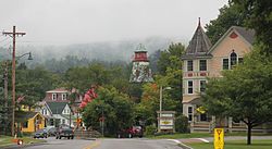
Ludlow architecture Ludlow, VT Architecture.JPG
Ludlow architecture

In the town, the population was spread out, with 21.0% under the age of 18, 6.5% from 18 to 24, 26.3% from 25 to 44, 27.6% from 45 to 64, and 18.7% who were 65 years of age or older. The median age was 43 years. For every 100 females, there were 96.2 males. For every 100 females age 18 and over, there were 93.3 males.

The median income for a household in the town was $36,969, and the median income for a family was $44,375. Males had a median income of $30,911 versus $22,179 for females. The per capita income for the town was $24,708. About 5.9% of families and 7.6% of the population were below the poverty line, including 8.6% of those under age 18 and 8.4% of those age 65 or over.

Notable people

Related Research Articles

<span class="mw-page-title-main">Windsor County, Vermont</span> County in Vermont, United States

Windsor County is a county located in the U.S. state of Vermont. As of the 2020 census, the population was 57,753. The shire town is the town of Woodstock. The county's largest municipality is the town of Hartford.

<span class="mw-page-title-main">Columbia, New Hampshire</span> Town in New Hampshire, United States

Columbia is a town in Coös County, New Hampshire, United States. The population was 659 at the 2020 census, down from 757 at the 2010 census. It is part of the Berlin, NH-VT micropolitan statistical area.

<span class="mw-page-title-main">Cornish, New Hampshire</span> Town in New Hampshire, United States

Cornish is a town in Sullivan County, New Hampshire, United States. The population was 1,616 at the 2020 census. Cornish has four covered bridges. Each August, it is home to the Cornish Fair.

Montague is a town in Lewis County, New York, United States. The population was 78 at the 2010 census. The town is named after Mary Montague Pierpont, the daughter of the original owner.

<span class="mw-page-title-main">Readsboro, Vermont</span> Town in Vermont, United States

Readsboro is a town in Bennington County, Vermont, United States. The town was named after John Reade, a landholder. The population was 702 at the 2020 census. The hamlet of Heartwellville is in the northern part of Readsboro, approximately 5 miles (8 km) north on Route 100 from the hamlet of Readsboro.

<span class="mw-page-title-main">Andover, Vermont</span> Town in Vermont, United States

Andover is a town in Windsor County, Vermont, United States. The population was 568 at the 2020 census.

<span class="mw-page-title-main">Baltimore, Vermont</span> Town in Vermont, United States

Baltimore is a town located in Windsor County, Vermont, United States. As of the 2020 census, the population of Baltimore was recorded as 229.

<span class="mw-page-title-main">Bridgewater, Vermont</span> Town in Vermont, United States

Bridgewater is a town in Windsor County, Vermont, United States. The population was 903 at the 2020 census. Bridgewater contains the hamlets of Bridgewater Village, Bridgewater Corners, West Bridgewater, and Bridgewater Center.

<span class="mw-page-title-main">Cavendish, Vermont</span> Town in Vermont, United States

Cavendish is a town in Windsor County, Vermont, United States. The town was likely named after William Cavendish, 4th Duke of Devonshire. The population was 1,392 at the 2020 census. The town of Cavendish includes the unincorporated villages of Cavendish and Proctorsville.

<span class="mw-page-title-main">Plymouth, Vermont</span> Town in Vermont, United States

Plymouth is a town in Windsor County, Vermont, United States. The population was 641 at the 2020 census. Calvin Coolidge, the 30th president of the United States, was born and raised in Plymouth and is buried there in the Plymouth Notch cemetery. The State of Vermont Division for Historic Preservation owns and maintains the Coolidge Homestead and the village of Plymouth Notch.

<span class="mw-page-title-main">Reading, Vermont</span> Town in Vermont, United States

Reading is a town in Windsor County, Vermont, United States. The population was 687 at the 2020 census.

<span class="mw-page-title-main">Rochester, Vermont</span> Town in Vermont

Rochester is a town in Windsor County, Vermont, United States. The population was 1,099 at the 2020 census. The central village is delineated as the Rochester census-designated place.

<span class="mw-page-title-main">Royalton, Vermont</span> Town in Vermont, United States

Royalton is a town in Windsor County, Vermont, United States. The population was 2,750 at the 2020 census. It includes the villages of Royalton, South Royalton, and North Royalton. Vermont Law School, the state's only accredited law school, is located in South Royalton.

<span class="mw-page-title-main">Sharon, Vermont</span> Town in Vermont, United States

Sharon is a town in Windsor County, Vermont, United States. It had a population of 1,560 at the 2020 census.

<span class="mw-page-title-main">Stockbridge, Vermont</span> Town in Vermont, United States

Stockbridge is a town in Windsor County, Vermont, United States, which contains the village of Gaysville. The population was 718 at the 2020 census. Stockbridge was one of thirteen Vermont towns isolated by flooding caused by Hurricane Irene in 2011.

<span class="mw-page-title-main">West Windsor, Vermont</span> Town in Vermont, United States

West Windsor is a town in Windsor County, Vermont, United States. The population was 1,344 at the 2020 census. It was known for its Ascutney Mountain Resort, which closed in 2010 and was bought by its citizens in 2015.

<span class="mw-page-title-main">Weston, Vermont</span> Town in Vermont, United States

Weston is a town in Windsor County, Vermont, United States. The population was 623 at the 2020 census. Home to the Weston Playhouse Theatre Company, it includes the villages of Weston and The Island.

<span class="mw-page-title-main">Windsor, Vermont</span> Town in Vermont, United States

Windsor is a town in Windsor County, Vermont, United States. As the "Birthplace of Vermont", the town is where the Constitution of Vermont was adopted in 1777, thus marking the founding of the Vermont Republic, a sovereign state until 1791, when Vermont joined the United States. Over much of its history, Windsor was home to a variety of manufacturing enterprises. Its population was 3,559 at the 2020 census.

<span class="mw-page-title-main">Springfield, Vermont</span> Town in Vermont, United States

Springfield is a town in Windsor County, Vermont, United States. As of the 2020 census, the population was 9,062.

<span class="mw-page-title-main">Ludlow (village), Vermont</span> Village in Vermont, United States

Ludlow is an incorporated village within the town of Ludlow, Windsor County, Vermont, United States. It is sometimes called Ludlow Village, to distinguish it from the surrounding town of the same name. The population was 773 at the 2020 census.

References

  1. 1 2 "U.S. Census website". United States Census Bureau . Retrieved January 31, 2008.
  2. "US Board on Geographic Names". United States Geological Survey. October 25, 2007. Retrieved January 31, 2008.
  3. "Census - Geography Profile: Ludlow town, Windsor County, Vermont". United States Census Bureau . Retrieved December 31, 2021.
  4. "Geographic Identifiers: 2010 Demographic Profile Data (G001): Ludlow town, Windsor County, Vermont". United States Census Bureau . Retrieved July 31, 2012.
  5. "PRISM Climate Group, Oregon State University". PRISM Climate Group, Oregon State University. Retrieved October 28, 2023. To find the table data on the PRISM website, start by clicking Coordinates (under Location); copy Latitude and Longitude figures from top of table; click Zoom to location; click Precipitation, Minimum temp, Mean temp, Maximum temp; click 30-year normals, 1991-2020; click 800m; click Interpolate grid cell values; click Retrieve Time Series button.
  6. "Ludlow, New Vermont 1991-2020 Monthly Normals" . Retrieved October 28, 2023.
  7. "U.S. Decennial Census". United States Census Bureau. Retrieved May 16, 2015.
  8. Calvin Coolidge Memorial Foundation, Calvin Coolidge, at his Graduation, May 23, 1890 Archived February 2, 2014, at the Wayback Machine , retrieved January 31, 2014
  9. John J. Duffy, Samuel B. Hand, Ralph H. Orth, editors, The Vermont Encyclopedia, 2003, page 156
  10. Susan Smallheer, Rutland Herald, Murphy Remembered as Iconic Citizen Legislator Archived March 27, 2016, at the Wayback Machine , November 22, 2011
  11. Daughters of the American Revolution (1912). Lineage Book - National Society of the Daughters of the American Revolution (Public domain ed.). Daughters of the American Revolution. pp. 182–.
  12. "John G. Sargent (1925–1929) | Miller Center". October 4, 2016.
  13. James Terry White, The National Cyclopaedia of American Biography, Volume XVII, 1920, page 235