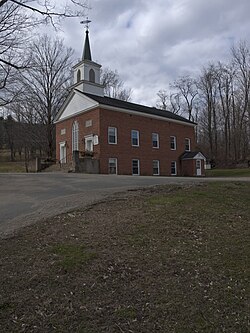
Perkinsville, Vermont | |
---|---|
Coordinates: 43°22′21″N72°30′56″W / 43.37250°N 72.51556°W | |
Country | United States |
State | Vermont |
County | Windsor |
Area | |
• Total | 0.19 sq mi (0.49 km2) |
• Land | 0.18 sq mi (0.47 km2) |
• Water | 0.01 sq mi (0.02 km2) |
Elevation | 561 ft (171 m) |
Population (2020) | |
• Total | 108 |
• Density | 570/sq mi (220/km2) |
Time zone | UTC−5 (Eastern (EST)) |
• Summer (DST) | UTC−4 (EDT) |
ZIP Code | 05151 |
Area code | 802 |
FIPS code | 50-54850 [2] |
GNIS feature ID | 1458942 [3] |
Perkinsville was a village located in the town of Weathersfield, Windsor County, Vermont, United States. The population was 108 at the 2020 census. [4]
The village government was dissolved in 2020; [5] the town of Weathersfield is now responsible for general governance, including village streetlights.
According to the United States Census Bureau, the village has a total area of 0.2 square miles (0.52 km2), all land.
Census | Pop. | Note | %± |
---|---|---|---|
1930 | 155 | — | |
1940 | 144 | −7.1% | |
1950 | 142 | −1.4% | |
1960 | 167 | 17.6% | |
1970 | 188 | 12.6% | |
1980 | 187 | −0.5% | |
1990 | 148 | −20.9% | |
2000 | 142 | −4.1% | |
2010 | 130 | −8.5% | |
2020 | 108 | −16.9% | |
U.S. Decennial Census [6] |
As of the census [2] of 2000, there were 142 people, 56 households, and 40 families residing in the village. The population density was 754.1 people per square mile (288.6/km2). There were 59 housing units at an average density of 313.3/sq mi (119.9/km2). The racial makeup of the village was 99.30% White and 0.70% African American.
There were 56 households, out of which 37.5% had children under the age of 18 living with them, 55.4% were married couples living together, 12.5% had a female householder with no husband present, and 26.8% were non-families. Of all households 21.4% were made up of individuals, and 14.3% had someone living alone who was 65 years of age or older. The average household size was 2.54 and the average family size was 2.88.
In the village, the population was spread out, with 26.8% under the age of 18, 4.9% from 18 to 24, 24.6% from 25 to 44, 27.5% from 45 to 64, and 16.2% who were 65 years of age or older. The median age was 40 years. For every 100 females, there were 94.5 males. For every 100 females age 18 and over, there were 82.5 males.
The median income for a household in the village was $22,708, and the median income for a family was $24,583. Males had a median income of $30,750 versus $23,182 for females. The per capita income for the village was $18,321. There were 18.6% of families and 19.9% of the population living below the poverty line, including 38.7% of under eighteens and 10.0% of those over 64.
Windsor County is a county located in the U.S. state of Vermont. As of the 2020 census, the population was 57,753. The shire town is the town of Woodstock. The county's largest municipality is the town of Hartford.
Hilltop is an unincorporated community and census-designated place in central Weathersfield Township, Trumbull County, Ohio, United States. The population was 658 at the 2020 census. It is part of the Youngstown–Warren metropolitan area.
Lemington is a town in Essex County, Vermont, United States. The population was 87 as of the 2020 census. It is part of the Berlin, NH –VT Micropolitan Statistical Area.
Derby Center is a village in the town of Derby, Orleans County, Vermont, United States. The population was 635 at the 2020 census.
Mount Tabor is a town in Rutland County, Vermont, United States. The population was 210 at the 2020 census.
Jacksonville is a village in the town of Whitingham, Windham County, Vermont, United States. The population was 213 at the 2020 census.
Weathersfield is a town in Windsor County, Vermont, United States. The population was 2,842 at the 2020 census.
Weston is a town in Windsor County, Vermont, United States. The population was 623 at the 2020 census. Home to the Weston Playhouse Theatre Company, it includes the villages of Weston and The Island.
Wilson is a village in Belmont and Monroe counties in the U.S. state of Ohio. The population was 129 at the 2020 census. It is part of the Wheeling metropolitan area.
Wayland is a town in Steuben County, New York, United States. The population was 3,733 at the 2020 census.
Cambridge is a village in the town of Cambridge, Lamoille County, Vermont, United States. The population was 210 at the 2020 census.
Hyde Park is a village in the town of Hyde Park, Lamoille County, Vermont, United States. The village population was 410 at the 2020 census.
Albany is a village in the town of Albany in Orleans County, Vermont, United States. The population was 166 at the 2020 census.
Marshfield is a village in the town of Marshfield in Washington County, Vermont, United States. The population was 229 at the 2020 census.
Waterbury is an unincorporated village and census-designated place (CDP) in the town of Waterbury, Washington County, Vermont, United States. The population was 1,897 at the 2020 census. The former village of Waterbury was dissolved in 2017, and its governmental functions were merged with the town of Waterbury.
Newfane is an incorporated village in the town of Newfane in Windham County, Vermont, United States. The population was 87 at the 2020 census.
Ludlow is a town in Windsor County, Vermont, United States. The population was 2,172 at the 2020 census. Ludlow is the home of Okemo Mountain, a popular ski resort. Before becoming a ski destination, Ludlow was originally a mill town, and was the home of a General Electric plant until 1977. It was arguably the most impacted by the flooding and natural disaster which ravaged Vermont in July 2023. The town of Ludlow was named after Ludlow, Massachusetts which is less than 100 miles away. There is also, where the town started, a village of Ludlow located in the town.
Springfield is a census-designated place (CDP) comprising the main settlement within the town of Springfield, Windsor County, Vermont, United States. The population of the CDP was 3,979 at the 2010 census, compared with 9,373 for the town as a whole.
Wyocena is a village in Columbia County, Wisconsin, United States. The population was 768 at the 2010 census. The village is located within the Town of Wyocena. It is part of the Madison Metropolitan Statistical Area.
Windsor is a village and former town in Dane County, Wisconsin. The population was 8,754 at the time of the 2020 census. The communities of Lake Windsor, Morrisonville, and Token Creek are located within the village. Windsor voted to incorporate as a village on November 3, 2015; prior to its incorporation, it was a town, and a portion of the town was a census-designated place. Windsor is a part of the Census Bureau's Madison metropolitan statistical area.