
Bridgewater is a town in Windsor County, Vermont, United States. The population was 903 at the 2020 census. Bridgewater contains the hamlets of Bridgewater Village, Bridgewater Corners, West Bridgewater, and Bridgewater Center.
West Rutland is the central village and a census-designated place (CDP) in the town of West Rutland, Rutland County, Vermont, United States. As of the 2020 census, it had a population of 1,898, out of 2,214 in the entire town of West Rutland.
Woodstock is an incorporated village located within the town of Woodstock in Windsor County, Vermont, United States. As of the 2020 census, the village population was 900.
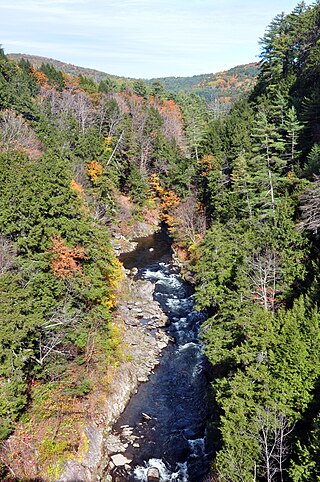
Quechee is a census-designated place and one of five unincorporated villages in the town of Hartford, Windsor County, Vermont, United States. As of the 2010 census, the population of the CDP was 656. It is the site of Quechee Gorge on the Ottauquechee River and is also the home to the Quechee Lakes planned community, initiated in the late 1960s, which also brought to the community the small Quechee Lakes Ski Area in the 1970s.

North Pownal is an unincorporated community and census-designated place (CDP) in the town of Pownal, Bennington County, Vermont, United States. It was first listed as a CDP prior to the 2020 census.
Waterbury Center is an unincorporated village and census-designated place (CDP) in the town of Waterbury, Washington County, Vermont, United States. As of the 2020 census, it had a population of 390.

North Hartland is a census-designated place (CDP) in the town of Hartland, Windsor County, Vermont, United States. As of the 2010 census, the population of the CDP was 302.

Hartland is a census-designated place (CDP) that comprises the central village of the town of Hartland, Windsor County, Vermont, United States. As of the 2010 census, the population of the CDP was 380, compared to 3,393 for the entire town of Hartland.

Windsor is a census-designated place (CDP) comprising the main settlement within the town of Windsor, Windsor County, Vermont, United States. The population of the CDP was 2,066 at the 2010 census, compared with 3,553 for the town as a whole.
Barnet is the primary village and a census-designated place (CDP) in the town of Barnet, Caledonia County, Vermont, United States. As of the 2020 census, the CDP had a population of 127, out of 1,663 in the entire town of Barnet.
Irasburg is the primary village and a census-designated place (CDP) in the town of Irasburg, Orleans County, Vermont, United States. As of the 2020 census, it had a population of 159, out of 1,233 in the entire town of Irasburg.
Lowell is the primary village and a census-designated place (CDP) in the town of Lowell, Orleans County, Vermont, United States. As of the 2020 census, it had a population of 254, out of 887 in the entire town of Lowell.
Troy is an unincorporated village and census-designated place (CDP) in the town of Troy, Orleans County, Vermont, United States. As of the 2020 census, it had a population of 261, out of 1,722 in the entire town of Troy.
Wilmington is the primary village and a census-designated place (CDP) in the town of Wilmington, Windham County, Vermont, United States. As of the 2020 census, it had a population of 439, compared to 2,255 in the entire town. The center of the village is part of the Wilmington Village Historic District.
Castleton Four Corners is a census-designated place (CDP) in the town of Castleton, Rutland County, Vermont, United States. It consists of the unincorporated villages of Castleton Corners and Hydeville. As of the 2020 census, the CDP had a population of 699, out of 4,458 in the entire town.
Killington Village is a census-designated place (CDP) in the town of Killington, Rutland County, Vermont, United States, comprising residential development associated with Killington Ski Resort. As of the 2020 census, Killington Village had a population of 861, out of 1,407 people in the entire town.
Middletown Springs is the primary village and a census-designated place (CDP) in the town of Middletown Springs, Rutland County, Vermont, United States. As of the 2020 census, it had a population of 194, out of 794 in the entire town.
Townshend is the primary village and a census-designated place (CDP) in the town of Townshend, Windham County, Vermont, United States. As of the 2020 census, it had a population of 199, compared to 1,291 in the entire town.
Whitingham is the central village and a census-designated place (CDP) in the town of Whitingham, Windham County, Vermont, United States. As of the 2020 census, it had a population of 91, compared to 1,344 in the entire town. Part of the village comprises the Whitingham Village Historic District.
Weston is the primary village and a census-designated place (CDP) in the town of Weston, Windsor County, Vermont, United States. As of the 2020 census, it had a population of 77, compared to 623 in the entire town.


