Randolph, Vermont

Last updated

Randolph, Vermont
Town
Randolph VT street.jpg
Downtown Randolph
Randolph, Vermont
Randolph town boundaries
Coordinates: 43°57′07″N72°39′54″W / 43.9520°N 72.6650°W / 43.9520; -72.6650
Country Flag of the United States.svg  United States
State Flag of Vermont.svg  Vermont
County Orange
Chartered1781 (Vermont)
Communities Randolph
Randolph Center
East Randolph
North Randolph
South Randolph
Area
  Total47.9 sq mi (124.1 km2)
  Land47.9 sq mi (124.0 km2)
  Water0.04 sq mi (0.1 km2)
Elevation
694 ft (420 m)
Population
 (2020)
  Total4,774
  Density100/sq mi (38/km2)
  Households
1,783
  Families
1,066
Time zone UTC−5 (EST)
  Summer (DST) UTC−4 (EDT)
ZIP Codes
05041 (East Randolph), 05061 (Randolph Center), 05060 (Randolph)
Area code 802
FIPS code 50-58075 [1]
GNIS feature ID1462182 [2]
Website randolphvt.org

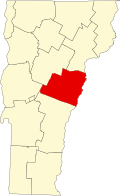
Randolph is a town in Orange County, Vermont, United States. The population was 4,774 at the 2020 census, [3] making Randolph the largest town in Orange County. The town is a commercial center for many of the smaller, rural farming communities that surround it.

Contents

When the area was originally settled there were three villages—Randolph Center, East Randolph and West Randolph—the current locations of the three fire departments. [4] What is now Randolph, the primary village of the town, had previously been the village of West Randolph.

History

Print of West Randolph from 1886 by L.R. Burleigh with listing of landmarks West Randolph, Vt. (2675175435).jpg
Print of West Randolph from 1886 by L.R. Burleigh with listing of landmarks

Vermont granted the town on November 2, 1780, when the New Hampshire settlers could not locate the original grantees, whose patents were issued by New York. It was chartered on June 29, 1781 to Aaron Storrs and 70 others, and was originally named "Middlesex". [5]

The town was first settled c.1778, when Vermont was an unrecognized state whose government existed in defiance of the government of New York, which claimed Vermont was a part of New York. To encourage recognition of the state by the United States, the town was renamed in honor of Edmund Randolph. [5]

With productive soil for cultivation, farming became an intensive industry. By 1830, when the population reached 2,743, between twelve and thirteen thousand sheep grazed its pastures. Randolph was noted for its good butter, cheese and mutton. [6]

Two branches of the White River provided water power for watermills. By 1859, the town had three gristmills, one oil mill, and one carding mill. [7] In 1848, the Vermont Central Railroad opened service through the town. Randolph's prosperity during the Victorian era endowed it with some fine architecture, including the Second Empire Randolph Railroad Depot and Renaissance Revival Kimball Public Library. [8]

In 1921, Randolph was the setting for, and provided some of the cast of, a silent movie called The Offenders. In 1922 the same was true for the film Insinuation.

Today, Randolph is a thriving meeting-spot and shopping center for the surrounding area. The town is home to attractions such as the Porter Music Box Museum and the Chandler Music Hall. Also located in Randolph are the Gifford Medical Center, a hospital; Dubois & King, a civil and structural engineering firm; and Randolph Union High School, which also serves students from the neighboring towns of Braintree and Brookfield. Downtown Randolph hosts the Amtrak station, shops, restaurants, Playhouse Movie Theatre, and several gas stations.
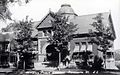
Geography

According to the United States Census Bureau, the town has a total area of 47.9 square miles (124.1 km2), of which 47.9 square miles (124.0 km2) is land and 0.04 square mile (0.1 km2) (0.08%) is water. Randolph is drained by the second and third branches of the White River.

Demographics

Historical population
CensusPop.Note
1790 893
1800 1,841106.2%
1810 2,25522.5%
1820 2,48710.3%
1830 2,74310.3%
1840 2,678−2.4%
1850 2,666−0.4%
1860 2,502−6.2%
1870 2,82913.1%
1880 2,9102.9%
1890 3,23211.1%
1900 3,141−2.8%
1910 3,1911.6%
1920 3,010−5.7%
1930 3,1665.2%
1940 3,2783.5%
1950 3,4996.7%
1960 3,414−2.4%
1970 3,88213.7%
1980 4,68920.8%
1990 4,7641.6%
2000 4,8531.9%
2010 4,778−1.5%
2020 4,774−0.1%
[9]

As of the census [1] of 2000, there were 4,853 people, 1,769 households, and 1,144 families residing in the town. The population density was 101.4 people per square mile (39.2/km2). There were 1,905 housing units at an average density of 39.8 per square mile (15.4/km2). The racial makeup of the town was 97.77% White, 0.21% African American, 0.14% Native American, 0.60% Asian, 0.08% Pacific Islander, 0.02% from other races, and 1.17% from two or more races. Hispanic or Latino of any race were 0.54% of the population.

There were 1,769 households, out of which 31.5% had children under the age of 18 living with them, 50.9% were couples living together and joined in either marriage or civil union, 9.6% had a female householder with no husband present, and 35.3% were non-families. 27.7% of all households were made up of individuals, and 12.6% had someone living alone who was 65 years of age or older. The average household size was 2.45 and the average family size was 3.00.

In the town, the population was spread out, with 23.3% under the age of 18, 15.9% from 18 to 24, 23.8% from 25 to 44, 23.1% from 45 to 64, and 13.9% who were 65 years of age or older. The median age was 36 years. For every 100 females, there were 103.1 males. For every 100 females age 18 and over, there were 105.4 males.

The median income for a household in the town was $41,283, and the median income for a family was $50,756. Males had a median income of $31,353 versus $25,160 for females. The per capita income for the town was $20,591. About 5.3% of families and 7.9% of the population were below the poverty line, including 7.7% of those under age 18 and 7.5% of those age 65 or over.

Education

The main campus of Vermont Technical College is located in Randolph Center.

Two public schools operated by the Orange Southwest Supervisory Union serve Randolph.

Transportation

Roads and highways

Randolph is served by five state-maintained routes. Interstate 89 passes through Randolph and has one exit near the center of town. Paralleling the Interstate are Vermont Route 12, which passes through downtown Randolph and the western half of town, and Vermont Route 14, which passes through the eastern half of town. East-west Vermont Route 66, which is located entirely within Randolph, connects all three of those north-south routes. Vermont Route 12A splits from Vermont Route 12 just north of downtown Randolph and heads to the northwest to enter Braintree.

Public transportation

Randolph Railroad Depot Randolph vt depot.jpg
Randolph Railroad Depot

Amtrak, the national passenger rail system, provides daily service to Randolph, operating its Vermonter between Washington, D.C. and St. Albans, Vermont. Tri-Valley Transit provides local bus transportation across town, Orange County and to and from the White River Junction and Lebanon, New Hampshire areas. [11]

Media

Weekly newspaper

The Herald of Randolph [12]

Radio

Sites of interest

Notable people

International relations

Randolph is twinned with:

See also

Related Research Articles

<span class="mw-page-title-main">Orange County, Vermont</span> County in Vermont, United States

Orange County is a county located in the U.S. state of Vermont. As of the 2020 census, the population was 29,277. Its shire town is the town of Chelsea. Orange County was organized on February 2, 1781, as an original county within the state.

<span class="mw-page-title-main">Chittenden County, Vermont</span> County in Vermont, United States

Chittenden County is the most populous county in the U.S. state of Vermont. As of the 2020 census, its population was 168,323. The county seat is Vermont's most populous municipality, the city of Burlington. The county has over a quarter of Vermont's population and more than twice the population of Vermont's second-most populous county, Rutland. The county also has more than twice the population density of Vermont's second-most dense county, Washington. The county is named for Vermont's first governor and one of the framers of its constitution as an independent republic and later U.S. state, Thomas Chittenden.

<span class="mw-page-title-main">Vergennes, Vermont</span> City in Vermont, United States

Vergennes is a city located in the northwest quadrant of Addison County, Vermont, United States. The municipality is bordered by the towns of Ferrisburgh, Panton, and Waltham. As of the 2020 census, its population was 2,553. It is the smallest of Vermont's 10 cities in terms of population, though the city of Winooski has the smallest area. It was the first city chartered in the state of Vermont and is the only city in Addison County.

<span class="mw-page-title-main">Ryegate, Vermont</span> Town in Vermont, United States

Ryegate is a town in Caledonia County, Vermont, United States. The population was 1,165 at the 2020 census. The town contains the villages of South Ryegate, East Ryegate, and Ryegate Corner.

<span class="mw-page-title-main">Richmond, Vermont</span> Town in Vermont, United States

Richmond is a town in Chittenden County, Vermont, United States. As of the 2020 census the population was 4,167. The main settlement of Richmond, in the north-central part of town, is a census-designated place (CDP), with a population of 853 at the 2020 census; it was formerly an incorporated village.

<span class="mw-page-title-main">Williston, Vermont</span> Town in Vermont, United States

Williston is a town in Chittenden County, Vermont, United States. Originally rural and laid out with many farms, in recent decades it has developed into a thriving suburb of Burlington, the largest city in the state of Vermont. As of the 2020 census, the population of Williston was 10,103, an increase of over 1,000 people since the 2010 census. Williston is one of the fastest-growing towns in Vermont, and while becoming more populated, it has also developed as a major retail center for the Burlington area as well as much of central and northern Vermont. The town has a National Register Historic District in its unincorporated central village.

<span class="mw-page-title-main">Braintree, Vermont</span> Town in Vermont, United States

Braintree is a town in Orange County, Vermont, United States created by Vermont charter on August 1, 1781. The population was 1,207 at the 2020 census. Braintree includes the places Braintree Center, Braintree Hill, East Braintree, West Braintree, Peth and Snowsville.

<span class="mw-page-title-main">Washington, Vermont</span> Town in Vermont, United States

Washington is a town in Orange County, Vermont, in the United States. The population was 1,032 at the 2020 census. The town is believed to be named after George Washington, although the town may also be named after Washington, Connecticut, as there are records of individuals moving from that town in Connecticut to Vermont around 1766.

<span class="mw-page-title-main">Derby, Vermont</span> Town in Vermont, United States

Derby is a town in Orleans County, Vermont, United States. The population was 4,579 at the 2020 census, making it the most populous community in Orleans County. The town contains four unincorporated villages: Beebe Plain, Clyde Pond, Lake Salem, and North Derby, and two incorporated villages: Derby Center and Derby Line.

<span class="mw-page-title-main">Pittsford, Vermont</span> Town in Vermont, United States

Pittsford is a town in Rutland County, Vermont, United States. As of the 2020 census, the town population was 2,862. Named for William Pitt, it has two picket forts used in the American Revolutionary War.

<span class="mw-page-title-main">Berlin, Vermont</span> Town in Vermont, United States

Berlin is a town in Washington County, Vermont, United States, founded in 1763.

<span class="mw-page-title-main">Hartford, Vermont</span> Town in Vermont, United States

Hartford is a town in Windsor County, Vermont, United States. It is on the New Hampshire border, at the intersection of Interstates 89 and 91. It is the site of the confluence of the White and Connecticut rivers; the Ottauquechee River also flows through the town. The town is composed of five unincorporated villages: Hartford, Quechee, West Hartford, White River Junction and Wilder. As of the 2020 census, the population was 10,686.

<span class="mw-page-title-main">Royalton, Vermont</span> Town in Vermont, United States

Royalton is a town in Windsor County, Vermont, United States. The population was 2,750 at the 2020 census. It includes the villages of Royalton, South Royalton, and North Royalton. Vermont Law School, the state's only accredited law school, is located in South Royalton.

<span class="mw-page-title-main">Windsor, Vermont</span> Town in Vermont, United States

Windsor is a town in Windsor County, Vermont, United States. As the "Birthplace of Vermont", the town is where the Constitution of Vermont was adopted in 1777, thus marking the founding of the Vermont Republic, a sovereign state until 1791, when Vermont joined the United States. Over much of its history, Windsor was home to a variety of manufacturing enterprises. Its population was 3,559 at the 2020 census.

<span class="mw-page-title-main">Middlebury, Vermont</span> Town in Vermont, United States

Middlebury is the shire town of Addison County, Vermont, United States. As of the 2020 census, the population was 9,152. Middlebury is home to Middlebury College and the Henry Sheldon Museum of Vermont History.

<span class="mw-page-title-main">Manchester, Vermont</span> Town in Vermont, United States

Manchester is a town in, and one of two shire towns of, Bennington County, Vermont. The population was 4,484 at the 2020 census.

<span class="mw-page-title-main">Swanton, Vermont (town)</span> Town in Vermont, United States

Swanton is a town in Franklin County, Vermont, United States. The population was 6,701 at the 2020 census. The town includes the village of Swanton.

<span class="mw-page-title-main">Hyde Park (town), Vermont</span> Town in Vermont, United States

Hyde Park is a town in and the shire town of Lamoille County, Vermont, United States. The town was named for Captain Jedediah Hyde, an early landowner who was a veteran of the American Revolutionary War. The population was 3,020 at the 2020 census. There is also a village of the same name within the town.

<span class="mw-page-title-main">Ludlow (village), Vermont</span> Village in Vermont, United States

Ludlow is an incorporated village within the town of Ludlow, Windsor County, Vermont, United States. It is sometimes called Ludlow Village, to distinguish it from the surrounding town of the same name. The population was 773 at the 2020 census.

<span class="mw-page-title-main">Milton, Vermont</span> Town in Vermont, United States

Milton is a town in Chittenden County, Vermont, United States. As of the 2020 census, the population was 10,723. According to local legend, the town was named for the English poet John Milton, but the name most likely originated from William FitzWilliam, 4th Earl FitzWilliam, who held the title Viscount Milton and was a supporter of independence for the colonies during the American Revolution.

References

  1. 1 2 "U.S. Census website". United States Census Bureau . Retrieved January 31, 2008.
  2. "US Board on Geographic Names". United States Geological Survey. October 25, 2007. Retrieved January 31, 2008.
  3. "Census - Geography Profile: Randolph town, Orange County, Vermont" . Retrieved January 4, 2022.
  4. "Randolph Fire Departments". Randolph VT town website. Retrieved January 28, 2018.
  5. 1 2 Randolph, Vermont, New England, USA. Virtualvermont.com (2013-05-25). Retrieved on 2014-04-12.
  6. "RANDOLPH, VERMONT • Historic New England". newenglandtowns.org. Retrieved March 13, 2018.
  7. Coolidge, Austin Jacobs; Mansfield, John Brainard (1859). A History and Description of New England, General and Local. A.J. Coolidge. p.  881. coolidge mansfield history description new england 1859.
  8. "History of Kimball Public Library".
  9. "Randolph Town, Vermont". United States Census Bureau. Retrieved August 27, 2021.
  10. "Randolph Union High School". orangesouthwest.org. Retrieved March 13, 2018.
  11. Main Page, Stagecoach Transportation Services. Retrieved 2015-12-17.
  12. The Herald of Randolph official site
  13. "Vermont Vital Records, 1720-1908, Birth Entry for Geo. W. Barker" . Ancestry.com. Lehi, UT: Ancestry.com, LLC. Retrieved February 2, 2020.
  14. "Death of George W. Barker". Argus and Patriot. Montpelier, VT. April 24, 1873. p. 2 via Newspapers.com.
  15. "Bakersfield: Funeral of the Hon. Calvin H. Blodgett to be Held To-Day". Burlington Free Press . Burlington, VT. August 5, 1919. p. 3 via Newspapers.com.
  16. "Biography, Harry H. Cooley" (PDF). Secretary of State Harry H. Cooley Papers. Montpelier, VT: Vermont Secretary of State. Vermont State Archives. p. 1.
  17. Maughan, Shannon (August 16, 2012). "Obituary: Jean Merrill". Publishers Weekly. Retrieved October 30, 2018.
  18. Jonathan P.Miller, Appletons Encyclopedia, Retrieved 4 August 2015
  19. Dodge, Prentiss Cutler (1912). Encyclopedia of Vermont Biography. Burlington, VT: Ullery Publishing Company. p.  272.
  20. Dodge, Prentiss Cutler (1912). Encyclopedia of Vermont Biography. Burlington, VT: Ullery Publishing Company. p.  87.
  21. Stone, Arthur F. (1929). The Vermont of Today. Vol. III. New York, NY: Lewis Historical Publishing Company. p. 29.
  22. Vermont Secretary of State, Vermont Legislative Directory, 1989, page 514