Brookfield, Vermont | |
|---|---|
Town | |
 Brookfield Old Town Hall | |
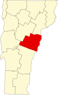
 Located in Orange County, Vermont | |
 Brookfield, Vermont Location within the U.S.A. | |
| Coordinates: 44°1′25″N72°36′0″W / 44.02361°N 72.60000°W | |
| Country | |
| State | |
| County | Orange |
| Chartered | 1781 |
| Settled | 1779 |
| Organized | 1785 |
| Communities | Brookfield Brookfield Center East Brookfield West Brookfield |
| Area | |
• Total | 41.7 sq mi (107.9 km2) |
| • Land | 41.4 sq mi (107.2 km2) |
| • Water | 0.3 sq mi (0.7 km2) |
| Elevation | 1,325 ft (333 m) |
| Population (2020) | |
• Total | 1,244 |
| • Density | 30/sq mi (11.6/km2) |
| • Households | 475 |
| • Families | 351 |
| Time zone | UTC-5 (EST) |
| • Summer (DST) | UTC-4 (EDT) |
| ZIP Codes | |
| Area code | 802 |
| FIPS code | 50-09325 [1] |
| GNIS feature ID | 1462054 [2] |
| Website | brookfieldvt.org |
Brookfield is a town in Orange County, Vermont, United States. It was created by Vermont charter on August 5, 1781. The population was 1,244 at the 2020 census. [3] Brookfield is best known for its floating bridge which spans Sunset Lake buoyed by pontoons. The bridge, which is the only floating bridge east of the Mississippi River, was originally built in 1820 by Luther Adams and his neighbors. Sunset Lake is also the site of an annual ice harvesting festival. Brookfield boasts that it has Vermont's oldest continually operating library dating back to 1791. In 2006, Brookfield was one of the first American towns to have its citizens pass a resolution endorsing the impeachment of President George W. Bush. As of September 2010, the floating bridge was closed for repairs. Work began in 2014, and was completed May 2015. There was a celebration from May 23–24, 2015, to memorialize the event. Governor Peter Shumlin attended, and cadets from Norwich University provided traffic control.
Contents
The town's modest village center is listed on the National Register of Historic Places as the Brookfield Village Historic District.