
Lake Champlain is a natural freshwater lake in North America mainly within the borders of the United States but also across the Canada–U.S. border into the Canadian province of Quebec.

Brookfield is a town in Orange County, Vermont, United States. It was created by Vermont charter on August 5, 1781. The population was 1,244 at the 2020 census. Brookfield is best known for its floating bridge which spans Sunset Lake buoyed by pontoons. The bridge, which is the only floating bridge east of the Mississippi River, was originally built in 1820 by Luther Adams and his neighbors. Sunset Lake is also the site of an annual ice harvesting festival. Brookfield boasts that it has Vermont's oldest continually operating library dating back to 1791. In 2006, Brookfield was one of the first American towns to have its citizens pass a resolution endorsing the impeachment of President George W. Bush. As of September 2010, the floating bridge was closed for repairs. Work began in 2014, and was completed May 2015. There was a celebration from May 23–24, 2015, to memorialize the event. Governor Peter Shumlin attended, and cadets from Norwich University provided traffic control.

Lake Washington is a large freshwater lake adjacent to the city of Seattle. It is the largest lake in King County and the second largest natural lake in the state of Washington, after Lake Chelan. It borders the cities of Seattle on the west, Bellevue and Kirkland on the east, Renton on the south and Kenmore on the north, and encloses Mercer Island. The lake is fed by the Sammamish River at its north end and the Cedar River at its south.
Newport is a city and the county seat of Orleans County, Vermont, United States. As of the 2020 Census, the population was 4,455. The city contains the second-largest population of any municipality in the county, and has the smallest geographic area. It is the second-smallest city by population in Vermont. Newport is also the name of a neighboring town in Orleans County.

Okanagan Lake is a lake in the Okanagan Valley of British Columbia, Canada. The lake is 135 km (84 mi) long, between 4 and 5 km wide, and has a surface area of 348 km2.
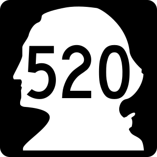
State Route 520 (SR 520) is a state highway and freeway in the Seattle metropolitan area, part of the U.S. state of Washington. It runs 13 miles (21 km) from Seattle in the west to Redmond in the east. The freeway connects Seattle to the Eastside region of King County via the Evergreen Point Floating Bridge on Lake Washington. SR 520 intersects several state highways, including Interstate 5 (I-5) in Seattle, I-405 in Bellevue, and SR 202 in Redmond.

The Evergreen Point Floating Bridge, officially the Governor Albert D. Rosellini Bridge, and commonly called the SR 520 Bridge or 520 Bridge, was a floating bridge in the U.S. state of Washington that carried State Route 520 across Lake Washington, connecting Medina with the Montlake/Union Bay district of Seattle.

The Lacey V. Murrow Memorial Bridge is a floating bridge in the Seattle metropolitan area of the U.S. state of Washington. It is one of the Interstate 90 floating bridges that carries the eastbound lanes of Interstate 90 across Lake Washington from Seattle to Mercer Island. Westbound traffic is carried by the adjacent Homer M. Hadley Memorial Bridge.

State Route 900 (SR 900) is a state highway serving part of King County, Washington, United States. It travels 16 miles (26 km) between southern Seattle and the Eastside suburbs of Renton and Issaquah, separated by the Issaquah Alps. The highway terminates to the west at an interchange with Interstate 5 (I-5) in Tukwila and to the east at I-90 in Issaquah, and also has intermediate junctions with I-405 and SR 167 in Renton.

The Third Lake Washington Bridge, officially the Homer M. Hadley Memorial Bridge, is a floating bridge in the Seattle metropolitan area of the U.S. state of Washington. It is one of the Interstate 90 floating bridges, carrying the westbound lanes of Interstate 90 across Lake Washington between Mercer Island and Seattle. The floating bridge is the fifth-longest of its kind in the world, at 5,811 feet.
The Ogdensburg and Lake Champlain Railroad was founded in 1849 as the Northern Railroad running from Ogdensburg to Rouses Point, New York. The 118-mile (190 km) railroad was leased by rival Central Vermont Railroad for several decades, ending in 1896. It was purchased in 1901 by the Rutland Railroad and became its Ogdensburg Division.

Mount Independence on Lake Champlain in Orwell, Vermont, was the site of extensive fortifications built during the American Revolutionary War by the American army to stop a British invasion. Construction began in July 1776, following the American defeat in Canada, and continued through the winter and spring of 1777. After the American retreat on July 5 and 6, 1777, British and Hessian troops occupied Mount Independence until November 1777.
Sunset Lake may refer to a place in the United States:

Vermont Route 65 (VT 65) is a 5.222-mile-long (8.404 km) east–west state highway within the town of Brookfield in Orange County, Vermont, United States. The western terminus of the route is at VT 12 in Brookfield. Its eastern terminus is at VT 14 in the village of East Brookfield. VT 65 traverses the Sunset Lake Floating Bridge and provides access to Allis State Park.

Interstate 90 (I-90), designated as the American Veterans Memorial Highway, is a transcontinental Interstate Highway that runs from Seattle, Washington, to Boston, Massachusetts. It crosses Washington state from west to east, traveling 298 miles (480 km) from Seattle across the Cascade Mountains and into Eastern Washington, reaching the Idaho state line east of Spokane. I-90 intersects several of the state's other major highways, including I-5 in Seattle, I-82 and U.S. Route 97 (US 97) near Ellensburg, and US 395 and US 2 in Spokane.
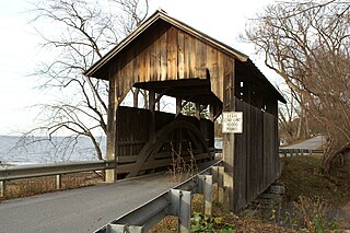
The Holmes Creek Covered Bridge, also called the Lakeshore Covered Bridge, is a one-lane wooden covered bridge that crosses Holmes Creek in Charlotte, Vermont on Lake Road, adjacent to Charlotte Beach. It was listed on the National Register of Historic Places in 1974.
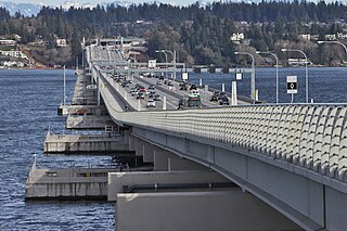
The Evergreen Point Floating Bridge, also known as the 520 Bridge and officially the Governor Albert D. Rosellini Bridge, carries Washington State Route 520 across Lake Washington from Seattle to its eastern suburbs. The 7,710-foot-long (2,350 m) floating span is the longest floating bridge in the world, as well as the world's widest measuring 116 feet (35 m) at its midpoint.
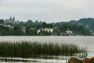
The Brookfield Village Historic District encompasses the 19th-century village center of Brookfield, Vermont. Arrayed on the eastern shore of Sunset Lake, it includes well-preserved examples of Greek Revival architecture, and is best known for the Sunset Lake Floating Bridge, a pontoon bridge that provides access to the village from the west. It was listed on the National Register of Historic Places in 1974.


