Fairlee, Vermont | |
---|---|
Coordinates: 43°54′28″N72°8′32″W / 43.90778°N 72.14222°W Coordinates: 43°54′28″N72°8′32″W / 43.90778°N 72.14222°W | |
Country | United States |
State | Vermont |
County | Orange |
Town | Fairlee |
Area | |
• Total | 0.66 sq mi (1.71 km2) |
• Land | 0.60 sq mi (1.56 km2) |
• Water | 0.06 sq mi (0.15 km2) |
Elevation | 430 ft (130 m) |
Population | 198 |
Time zone | UTC-5 (Eastern (EST)) |
• Summer (DST) | UTC-4 (EDT) |
ZIP Code | 05045 |
Area code(s) | 802 |
FIPS code | 50-25600 |
GNIS feature ID | 2586631 [3] |
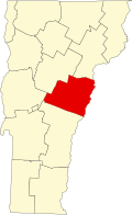
Fairlee is the primary village and a census-designated place (CDP) in the town of Fairlee, Orange County, Vermont, United States. As of the 2020 census, it had a population of 198 [2] out of 988 in the entire town of Fairlee.
The CDP is on the eastern edge Orange County, in the southeast part of the town of Fairlee. It is bordered to the east by the Connecticut River, which forms the Vermont–New Hampshire border. The town of Orford, New Hampshire, is to the east across the river. U.S. Route 5 passes through the center of the village, and Interstate 91 runs along the western edge. Both highways lead north 7 miles (11 km) to Bradford and south the same distance to Thetford. Vermont Route 25A leads east 350 feet (110 m) to the Samuel Morey Memorial Bridge across the Connecticut River, at which point it becomes New Hampshire Route 25A, leading into Orford.
Walpole is a town in Cheshire County, New Hampshire, United States. The population was 3,633 at the 2020 census.
Woodsville is a census-designated place (CDP) and the largest village in the town of Haverhill in Grafton County, New Hampshire, United States, along the Connecticut River at the mouth of the Ammonoosuc River. The population was 1,431 at the 2020 census. Although North Haverhill is now the county seat of Grafton County, the village of Woodsville has traditionally been considered the county seat, as the county courthouse was originally located there. The county buildings are now located halfway between Woodsville and the village of North Haverhill to the south.
Fairlee is a town in Orange County, Vermont, United States. The population was 988 at the 2020 census. It includes the village of Ely. Fairlee is home to Lake Morey, which claims to have the longest ice skating trail in the United States.
Charlestown is a census-designated place (CDP) and the main village in the town of Charlestown, Sullivan County, New Hampshire, United States. The population of the CDP was 1,078 at the 2020 census, out of 4,806 in the entire town.
New Hampshire Route 10 is a 122.25-mile-long (196.74 km) north–south state highway in western New Hampshire, United States. Its southern terminus is in Winchester at the Massachusetts state line, where it continues south as Massachusetts Route 10. Administratively, the northern terminus is at a junction with U.S. Route 302 in Haverhill.
New Hampshire Route 25 is a 96.62-mile (155.49 km) long east–west state highway in New Hampshire. It runs completely across the state from Vermont to Maine.
North Haverhill is an unincorporated community and census-designated place (CDP) in the town of Haverhill in Grafton County, New Hampshire, United States. It is one of several villages in the town of Haverhill, which is the county seat of Grafton County. As of the 2020 census, North Haverhill had a population of 843.
Colebrook is a census-designated place (CDP) and the main village in the town of Colebrook, Coös County, New Hampshire, United States. The population of the CDP was 1,201 at the 2020 census, out of 2,084 in the entire town. The CDP population had dropped from 1,394 at the 2010 census.
North Walpole is a census-designated place (CDP) in the town of Walpole in Cheshire County, New Hampshire, United States. It had a population of 785 at the 2020 census, making it the largest village in the town of Walpole.
Walpole is a census-designated place (CDP) and the central village in the town of Walpole in Cheshire County, New Hampshire, United States. The population of the CDP was 573 at the 2020 census, compared to 3,633 in the entire town.
Norwich is a census-designated place (CDP) that comprises the central village of the town of Norwich, Windsor County, Vermont, United States. As of the 2010 census, the population of the CDP was 878, compared to 3,414 for the entire town of Norwich.
Barnet is the primary village and a census-designated place (CDP) in the town of Barnet, Caledonia County, Vermont, United States. As of the 2020 census, the CDP had a population of 127, out of 1,663 in the entire town of Barnet.
Randolph is the primary village and a census-designated place (CDP) in the town of Randolph, Orange County, Vermont, United States. As of the 2020 census, it had a population of 2,083, out of 4,774 in the entire town of Randolph.
Putney is the primary village and a census-designated place (CDP) in the town of Putney, Windham County, Vermont, United States. As of the 2020 census, it had a population of 571, compared to 2,617 in the entire town. The Putney Village Historic District occupies the center of the CDP.
Chelsea is the primary village and a census-designated place (CDP) in the town of Chelsea, Orange County, Vermont, United States. It was first listed as a CDP prior to the 2020 census.
Lyndon is a census-designated place (CDP) in the town of Lyndon, Caledonia County, Vermont, United States, corresponding to the unincorporated village originally known as Lyndon Corner. The community was first listed as a CDP prior to the 2020 census, at which it had a population of 203.
Sheffield is the primary village and a census-designated place (CDP) in the town of Sheffield, Caledonia County, Vermont, United States. It was first listed as a CDP prior to the 2020 census.
Castleton Four Corners is a census-designated place (CDP) in the town of Castleton, Rutland County, Vermont, United States. It consists of the unincorporated villages of Castleton Corners and Hydeville. As of the 2020 census, the CDP had a population of 699, out of 4,458 in the entire town.
Middletown Springs is the primary village and a census-designated place (CDP) in the town of Middletown Springs, Rutland County, Vermont, United States. As of the 2020 census, it had a population of 194, out of 794 in the entire town.
Townshend is the primary village and a census-designated place (CDP) in the town of Townshend, Windham County, Vermont, United States. As of the 2020 census, it had a population of 199, compared to 1,291 in the entire town.