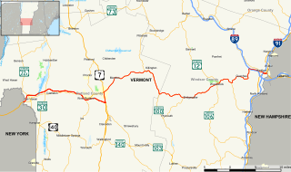
New Hampshire Route 119 is a state highway in the U.S. state of New Hampshire. The highway begins in Hinsdale at the Connecticut River, across which the highway continues into Brattleboro, Vermont, as Vermont Route 119 for 0.080 miles (0.129 km) to its terminus at U.S. Route 5 and VT 142. NH 119 heads east 39.908 miles (64.226 km) to the Massachusetts state line in New Ipswich, where the highway continues as Massachusetts Route 119. The state highway is the main east–west highway of southern Cheshire County, where it connects the towns of Hinsdale, Winchester, Richmond, Fitzwilliam, and Rindge.

New York State Route 149 (NY 149) is an east–west state highway that runs for 32.20 miles (51.82 km) through the Capital District of New York in the United States. It begins at exit 20 on the Adirondack Northway in the Warren County town of Queensbury and intersects U.S. Route 9 (US 9), US 4, and NY 22, among other routes, as it progresses eastward to its eastern end at the Vermont state line in the Washington County village of Granville. Here, the highway becomes Vermont Route 149 (VT 149) and continues for an additional 1.302 miles (2.095 km) to an intersection with VT 30 in Rutland County. Both NY 149 and VT 149 traverse mostly rural areas.

Vermont Route 103 is a north–south state highway in southern Vermont, United States. It runs from Rockingham in the east to Clarendon near Rutland in the west. The Vermont Country Store's second branch is one attraction along the route, as well as the Okemo Ski Resort in Ludlow.

Vermont Route 11 is an east–west state highway in Vermont, United States. The western end of the highway is at Vermont Route 7A in Manchester. The eastern end is at the New Hampshire border at the Cheshire Bridge over the Connecticut River, connecting Springfield, Vermont and Charlestown, New Hampshire. The route continues into New Hampshire as New Hampshire Route 11, and then following that into Maine as Maine State Route 11. The three Routes 11, totaling 551.7 miles (887.9 km) in length, were once part of the New England Interstate system.

Vermont Route 22A is a state highway in western Vermont, United States. It is the northward continuation of New York State Route 22A. Its southern end is at the New York state line in Fair Haven and its northern end is in Ferrisburgh at U.S. Route 7. As it is an extension of NY 22A, VT 22A is a spur route of NY 22, which runs roughly parallel to VT 22A west of the state border. This is a rather unusual case of one state having a suffixed route of another state's primary route. Vermont does not currently have a "Route 22."

Vermont Route 15 is an east–west state highway in northern Vermont, United States. Its western terminus is at U.S. Route 2 and U.S. Route 7 in Winooski and its eastern terminus is at US 2 in Danville. It runs for 68.984 miles (111.019 km) and is known as the Grand Army of the Republic Highway for its entirety.

Vermont Route 9 is a state highway in the U.S. state of Vermont. The highway runs 46.957 miles (75.570 km) from the New York state line in Bennington, where it continues west as New York Route 7, to the New Hampshire state line at the Connecticut River in Brattleboro, where the highway continues as New Hampshire Route 9. VT 9 is the primary east–west highway of Bennington and Windham counties in southern Vermont. The highway connects Southern Vermont's primary towns of Bennington and Brattleboro via its crossing of the Green Mountains. VT 9 also connects those towns with Troy, New York, and Keene, New Hampshire, via the connecting highways in those states. The highway also intersects three major north–south routes: U.S. Route 7 in Bennington and Interstate 91 (I-91) and US 5 in Brattleboro.
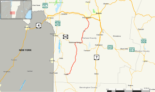
Vermont Route 133 is a 22.476-mile (36.172 km) north–south state highway in Rutland County, Vermont, United States. It runs from Pawlet in the south to West Rutland in the north.

Vermont Route 30 (VT 30) is a north–south state highway in the U.S. state of Vermont which runs from Brattleboro in the south to Middlebury in the north. The northern portion, from Poultney to Middlebury, was part of the New England road marking system's Route 30, from which VT 30 got its number. The route passes through many historic small towns, and travel writers such as those at Southern Vermont have described the route as "idyllic" and "picturesque".
New York State Route 346 (NY 346) and Vermont Route 346 (VT 346) are short, adjoining state highways in the northeastern United States. Together, they extend for a combined 7.25 miles (11.67 km) through the towns of Petersburgh in Rensselaer County, New York, and Pownal in Bennington County, Vermont. The bi-state highway begins at an intersection with NY 22 in the hamlet of North Petersburgh and heads generally southeastward across the New York–Vermont state line to a junction with U.S. Route 7 (US 7) in the village of Pownal. Both NY 346 and VT 346 parallel the Hoosick River.

New York State Route 22A (NY 22A) is a short north–south state highway located within Washington County, New York, in the United States. The route extends for 10.6 miles (17.1 km) from an intersection with NY 22 in the town of Granville to the Vermont state line in the town of Hampton, where it becomes Vermont Route 22A (VT 22A). NY 22A was originally designated as New York State Route 286 in the 1930 renumbering of state highways in New York. It was renumbered to its current designation in the early 1940s.
New York State Route 74 (NY 74) and Vermont Route 74 (VT 74) are adjoining state highways in the northeastern United States, connected by one of the last remaining cable ferries in North America. Together they extend for 34 miles (55 km) through Essex County, New York, and Addison County, Vermont. NY 74 begins at exit 28 off Interstate 87 (I-87) in the hamlet of Severance in the Adirondack Mountains region of the northern part of New York State. It extends 20.44 miles (32.89 km) to the western shore of Lake Champlain in Ticonderoga. There, the seasonal Fort Ticonderoga–Larrabees Point Ferry carries cars across the state border into Vermont, where VT 74 starts at the lake's eastern shore and terminates 13.26 miles (21.34 km) later at a junction with VT 30 in the town of Cornwall.

Vermont Route 17 (VT 17) is a 40.409-mile (65.032 km) long state highway in western Vermont in the United States. The western terminus of the route is at the New York state line in Addison, where it connects to New York State Route 185 (NY 185) by way of the Lake Champlain Bridge. Its eastern terminus is at a junction with VT 100 in Waitsfield. VT 17 was initially much shorter than it is today, extending from the Champlain Bridge to Addison upon assignment. It was extended east through the Green Mountains to Waitsfield in 1965.
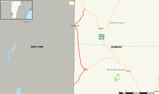
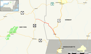
Vermont Route 153 (VT 153) is a state highway in southwestern Vermont in the United States. It extends for 13.14 miles (21.15 km) from the New York state line at Rupert to VT 30 in Pawlet. VT 153 is entirely town-maintained and goes through Bennington and Rutland counties.
In the U.S. state of Vermont, U.S. Route 4 (US 4) extends for 66.06 miles (106.31 km) between the New York state line at Fair Haven and the New Hampshire state line at White River Junction. It is one of the main arteries between New York and New Hampshire.

Pennsylvania Route 425 is an 24-mile-long (39 km) state highway located in York county in Pennsylvania. The southern terminus is at PA 851 in Fawn Grove. The northern terminus is at PA 124/PA 624 in Craley. PA 425 is a two-lane undivided road that runs through rural areas in southeastern York County. The route heads north from Fawn Grove and passes through Woodbine before it forms a concurrency with PA 74 in Airville. From here, PA 425 heads northeast to York Furnace, where it briefly follows the west bank of the Susquehanna River before heading northwest away from the river. The route continues west to New Bridgeville, where it turns north and curves west to continue to its terminus in Craley.
Vermont Route 129 is a short, 5.415-mile (8.715 km) connector route for Isle La Motte and Alburgh in the state of Vermont in the United States. VT 129 begins at an intersection in the centre of Isle La Motte, heads northward and terminates at an intersection with U.S. Route 2 in Alburgh. The route originated as Vermont Route F-2 in 1926, and was the name of the road that approached a ferry to Chazy. Route F-2 followed the same routing as the current VT 129, to which it was renumbered in 1944.

Vermont Route 144 is an east–west state highway in Rutland County, Vermont, United States. It extends from VT 22A in Benson to VT 30 in Sudbury. VT 144 also passes through the extreme northwestern corner of Hubbardton. All of VT 144 is town-maintained.
Vermont Route 140 (VT 140) is a state highway in the U.S. state of Vermont. The highway runs 25.059 miles (40.329 km) from VT 30 in Poultney east to VT 103 in Mount Holly. VT 140 connects the southern Rutland County towns of Poultney, Middletown Springs, Tinmouth, Wallingford, and Mount Holly.