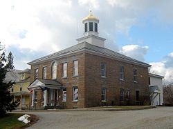
North Hero, Vermont | |
---|---|
Coordinates: 44°49′52″N73°16′25″W / 44.83111°N 73.27361°W | |
Country | United States |
State | Vermont |
County | Grand Isle |
Area | |
• Total | 46.6 sq mi (120.6 km2) |
• Land | 13.4 sq mi (34.8 km2) |
• Water | 33.1 sq mi (85.8 km2) |
Elevation | 105 ft (32 m) |
Population (2020) | |
• Total | 939 |
• Density | 70/sq mi (27.0/km2) |
Time zone | UTC-5 (Eastern (EST)) |
• Summer (DST) | UTC-4 (EDT) |
ZIP code | 05474 |
Area code | 802 |
FIPS code | 50-50650 [1] |
GNIS feature ID | 1462164 [2] |
Website | www |
North Hero is a town in and the shire town [3] (county seat) [4] of Grand Isle County, Vermont, United States. The population was 939 at the 2020 census. [5]
The town was named in honor of the American Revolutionary War hero Ethan Allen. [6]
The North Hero Town Office is at 6441 US Route 2 and shares a building with the town school. [7]
North Hero is in the center of Grand Isle County and occupies the entire North Hero Island in Lake Champlain, as well as Knight Island, Butler Island, and a handful of much smaller islands. The town is bordered to the north by Alburgh, to the west by Isle La Motte, and to the south by the town of Grand Isle, all in Grand Isle County. To the east, across Lake Champlain, are the towns of St. Albans and Swanton in Franklin County, Vermont, while to the southwest, across the western arm of Lake Champlain, is the town of Beekmantown in Clinton County, New York.
U.S. Route 2 crosses North Hero from north to south, departing the town in the north by a bridge over the Alburg Passage into the town of Alburgh, and in the south by a bridge over The Gut to South Hero Island (Grand Isle).
According to the United States Census Bureau, the town of North Hero has an area of 46.6 square miles (120.6 km2), of which 13.4 square miles (34.8 km2) is land and 33.1 square miles (85.8 km2), or 71.11%, is water. [8]
Census | Pop. | Note | %± |
---|---|---|---|
1790 | 125 | — | |
1800 | 324 | 159.2% | |
1810 | 552 | 70.4% | |
1820 | 503 | −8.9% | |
1830 | 638 | 26.8% | |
1840 | 716 | 12.2% | |
1850 | 730 | 2.0% | |
1860 | 594 | −18.6% | |
1870 | 601 | 1.2% | |
1880 | 637 | 6.0% | |
1890 | 550 | −13.7% | |
1900 | 712 | 29.5% | |
1910 | 496 | −30.3% | |
1920 | 494 | −0.4% | |
1930 | 485 | −1.8% | |
1940 | 442 | −8.9% | |
1950 | 407 | −7.9% | |
1960 | 328 | −19.4% | |
1970 | 364 | 11.0% | |
1980 | 442 | 21.4% | |
1990 | 502 | 13.6% | |
2000 | 810 | 61.4% | |
2010 | 803 | −0.9% | |
2020 | 939 | 16.9% | |
U.S. Decennial Census [9] |
As of the census [1] of 2000, there were 810 people, 333 households, and 237 families residing in the town. The population density was 58.9 people per square mile (22.8/km2). There were 906 housing units at an average density of 65.9 per square mile (25.5/km2). The racial makeup of the town was 97.53% White, 0.25% African American, 0.25% Native American, 0.37% Pacific Islander, and 1.60% from two or more races. Hispanic or Latino of any race were 0.62% of the population.
There were 333 households, of which 26.7% had children under 18 living with them, 61.0% were married couples living together, 6.3% had a female householder with no husband present, and 28.8% were non-families. 19.5% of all households were made up of individuals, and 5.1% had someone living alone who was 65 or older. The average household size was 2.43 and the average family size was 2.79.
In the town, the population was spread out, with 21.9% under 18, 4.8% from 18 to 24, 26.7% from 25 to 44, 34.3% from 45 to 64, and 12.3% who were 65 or older. The median age was 43. For every 100 females, there were 101.5 males. For every 100 females age 18 and over, there were 101.0 males.
The median income for a household in the town was $45,577, and the median income for a family was $51,964. Males had a median income of $36,875 versus $31,125 for females. The per capita income was $26,859. About 5.5% of families and 9.0% of the population were below the poverty line, including 12.9% of those under 18 and 4.0% of those 65 or older.
North Hero is the home of the weekly newspaper The Islander, which has been published in North Hero since 1974, and covers the northern Champlain Valley. [10] [11]
Grand Isle County is a county in the U.S. state of Vermont. As of the 2020 census, the population was 7,293, making it Vermont's second-least populous county. Its shire town is North Hero. The county was created in 1802 and organized in 1805.
Chittenden County is the most populous county in the U.S. state of Vermont. As of the 2020 census, its population was 168,323. The county seat is Vermont's most populous municipality, the city of Burlington. The county has over a quarter of Vermont's population and more than twice the population of Vermont's second-most populous county, Rutland. The county also has more than twice the population density of Vermont's second-most dense county, Washington. The county is named for Vermont's first governor and one of the framers of its constitution as an independent republic and later U.S. state, Thomas Chittenden.
Cumberland Head is a census-designated place and region of the town of Plattsburgh in Clinton County, New York, United States. The population was 1,627 at the 2010 census.
Panton is a town in Addison County, Vermont, United States. The population was 646 at the 2020 census.
Colchester is a town in Chittenden County, Vermont, United States. As of the 2020 census, the population of Colchester was 17,524. It is the third-most populous municipality and most populous town in the state of Vermont. Colchester borders Burlington, Vermont's most populous municipality. The town is directly to Burlington's north on the eastern shore of Lake Champlain, to the west of the Green Mountains. The Vermont National Guard is based in the town, and it is also home to Saint Michael's College and the Vermont campus of Southern New Hampshire University.
Fairfax is a town in Franklin County, Vermont, United States, with a population of 5,014 at the 2020 census.
Franklin is a town in Franklin County, Vermont, United States. The population was 1,363 at the 2020 census. The original name was "Huntsburgh", but the name was changed to "Franklin" in 1817.
Georgia is a town in Franklin County, Vermont, United States. The population was 4,845 at the 2020 census.
Highgate is a town in Franklin County, Vermont, United States. The population was 3,472 at the 2020 census. The town is on the Canada–US border and is a border town with Philipsburg, Quebec.
Sheldon is a town in Franklin County, Vermont, United States. The population was 2,136 at the 2020 census. It contains the unincorporated community of Sheldon Springs.
Grand Isle is a town on Grand Isle in Grand Isle County, Vermont, United States. The population was 2,086 at the 2020 census.
Isle La Motte is an island in Lake Champlain in northwestern Vermont, United States. At 7 mi (11 km) by 2 mi (3 km), it lies close to the place that the lake empties into the Richelieu River. It is incorporated as a New England town in Grand Isle County. Its population was 488 at the 2020 census.
South Hero is a town on Grand Isle in Grand Isle County, Vermont, United States. South Hero's population was 1,674 at the 2020 census.
Champlain is a town in Clinton County, New York, United States. The population was 5,754 at the 2010 census. The town is located on the western shore of Lake Champlain, near the northern end of Lake Champlain and is on the U.S./Canadian border.
Plattsburgh is a town in Clinton County, New York, United States. The population was 11,886 at the 2020 census. The town is named after Zephaniah Platt, an early land owner, and it surrounds the separate and more populous city of the same name. The town is in the eastern part of the county, in the North Country region of the state of New York. The region's airport, Plattsburgh International Airport, is located in the southern part of the town.
Swanton is a village in the town of Swanton in Franklin County, Vermont, United States. It is sometimes called Swanton Village to distinguish it from the surrounding town of the same name. The population was 2,328 at the 2020 census. It was founded in 1888.
Swanton is a town in Franklin County, Vermont, United States. The population was 6,701 at the 2020 census. The town includes the village of Swanton.
Alburgh is a village within the town of the same name in Grand Isle County, Vermont, United States. The population was 571 at the 2020 census. The town's name came from the person primarily responsible for chartering the community, Ira Allen.
Alburgh is a town in Grand Isle County, Vermont, United States, founded in 1781 by Ira Allen. The population was 2,106 at the 2020 United States Census. Alburgh is on the Alburgh Tongue, a peninsula extending from Canada into Lake Champlain, and lies on the only road-based route across Lake Champlain to New York state north of Addison, Vermont.
Addison is a town in Addison County, Vermont, United States. It was founded October 14, 1761. The population was 1,365 at the 2020 census.