
Burke is a town in Caledonia County, Vermont, United States. The population was 1,651 at the 2020 census. The town contains the villages of East Burke, West Burke and Burke Hollow. The town is home to Burke Mountain and Burke Mountain Academy.

Westmore is a town in Orleans County, Vermont, United States. The population was 357 at the 2020 census, making it the least populated and least densely populated town in the county. The town contains one unincorporated village clustered around Lake Willoughby.
The Northeast Kingdom is the northeast corner of the U.S. state of Vermont, approximately comprising Essex, Orleans and Caledonia counties and having a population at the 2010 census of 64,764. The term "Northeast Kingdom" is attributed to George D. Aiken, former Governor of Vermont and a U.S. senator, who first used the term in a 1949 speech.

The Green Mountains are a mountain range in the U.S. state of Vermont. The range runs primarily south to north and extends approximately 250 miles (400 km) from the border with Massachusetts to the border with Quebec, Canada. The part of the same range that is in Massachusetts and Connecticut is known as The Berkshires or the Berkshire Hills and the Quebec portion is called the Sutton Mountains, or Monts Sutton in French.
The Presidential Range is a mountain range in the Green Mountains of the U.S. state of Vermont. All of the summits of the peaks in the range are located in Addison County but the eastern slopes in the northern part of the range extend into Washington County. The major peaks in the range are named for several U.S. presidents from the period of the American Civil War through World War I.
Mount Ascutney is a mountain in the U.S. state of Vermont. At 3,144 feet (958 m), it is the second-highest peak in Windsor County. Mount Ascutney is a monadnock that rises abruptly from the surrounding lowlands. For example, the Windsor Trail is 2.7 miles (4.3 km) to the summit with 2,514 feet (766 m) of elevation gain and an overall 18% grade. Particularly noteworthy are the mountain's granite outcrops, one of which, near the summit, serves as a launching point for hang-gliders.

Mount Ellen is a mountain in the Green Mountains in the U.S. state of Vermont. Located at the northern edge of the Green Mountain National Forest in Washington County, the summit of Mount Ellen is in the northwest corner of Warren but the mountain extends into Fayston to the north and Lincoln to the west. Together with Lincoln Peak to the south, the slopes of Mount Ellen are home to the Sugarbush Resort.

Mount Frissell, 2,454 feet (748 m), which straddles the border of southwest Massachusetts and northwest Connecticut, is a prominent peak of the Taconic Range. Frissel's south slopes include the highest point in Connecticut.

Lake Memphremagog is a fresh water glacial lake located between Newport, Vermont, United States and Magog, Quebec, Canada. The lake spans both Quebec and Vermont, but is mostly in Quebec. Most of the watershed that feeds the lake is located in Vermont, and is a source for accumulated phosphorus, sediments and other pollutants. Cleanup efforts since the late 1980s have improved the water quality. The lake furnishes potable water for 200,000 people.
The Northern Forest Canoe Trail (NFCT) is a 740-mile (1,190 km) marked canoeing trail in the northeastern United States and Canada, extending from Old Forge in the Adirondacks of New York to Fort Kent, Maine. Along the way, the trail also passes through the states and provinces of Vermont, Quebec, and New Hampshire. The trail was opened on June 3, 2006.

Lake Willoughby is a lake in the town of Westmore in Orleans County in the Northeast Kingdom of Vermont, United States.

Ascutney Mountain Resort was a downhill ski area on the western side of Mount Ascutney in Brownsville, Vermont that operated from 1946 until 2010. It was purchased by local communities and the Trust for Public Land in 2015, with plans to reopen a smaller version of a ski area, and keep the rest of the mountain preserved.
Lincoln Peak is a mountain located on the border between Addison and Washington counties in the U.S. state of Vermont. It is part of the Lincoln Mountain section of the Green Mountains in the Green Mountain National Forest. Lincoln Peak is flanked to the southwest by Mount Abraham, and to the north by Nancy Hanks Peak, which was named after Abraham Lincoln's assassination.

Mount Pisgah is a mountain in Westmore, Vermont. It is located on the east side of Lake Willoughby and constitutes the eastern side of "Willoughby Gap". It is part of the Northeastern Highlands of Vermont. There are hiking trails in Willoughby State Forest.

The Robert Frost Trail is a 47-mile (76 km) long footpath that passes through the eastern Connecticut River Valley of Massachusetts. The trail runs from the Connecticut River in South Hadley, Massachusetts to Ruggles Pond in Wendell State Forest, through both Hampshire and Franklin County and includes a number of scenic features such as the Holyoke Range, Mount Orient, Puffer's Pond, and Mount Toby. The trail is named after the poet Robert Frost, who lived and taught in the area from 1916 to 1938.
Mount Sunapee Resort is a ski area and resort located in Mount Sunapee State Park in Newbury, New Hampshire, United States.
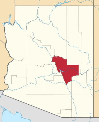
The Mescal Mountains are a series of connected mountain ridges in southern Gila County, Arizona. Their highest point is El Capitan Mountain, which has an elevation of 6,568 ft and a prominence of 1,828 ft. The highest point has a topographic isolation of 5.98 miles, with the nearest point of equal or greater elevation being to the north west in the Pinal Mountains. The mountain ridges are visible in the east from Arizona State Route 77 between Globe and Winkelman.The range is approximately 10 miles west of San Carlos Lake, which lies in the San Carlos Apache Indian Reservation; the ridges themselves also mostly fall within the boundary of the reservation, with the exception of the western section and the high point. As such, hiking the ridge may require special permission from San Carlos Apache Indian Reservation, although no trails exist on the mountains themselves or leading to them. The ridge's relative proximity to the more visually dominant Pinal Mountains, make it an often-overlooked feature. The range is one of many to occur in the Arizona transition zone.
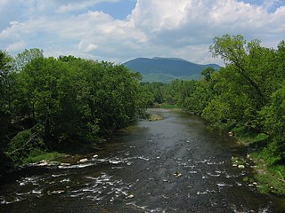
The Willoughby River is a tributary of the Barton River, flowing on 18.6 km (11.6 mi), in the Orleans County, Vermont, United States.
Mount Tom is a small peak, standing at 1357 feet, located in the town of Woodstock, Vermont. It is a part of the Marsh-Billings-Rockefeller National Historical Park. The peak has a multitude of hiking, running, and Nordic skiing trails, and has many sites dedicated to the national park. Standing in the middle of Woodstock, Vermont, the peak also is host to many annual town events, including the Road to the Pogue Race. Visible from the top are sights such as the village of Woodstock, the sister peak of Mount Tom, the Ottauquechee River, Vermont Route 4A, and many neighboring mountains.

Willoughby State Forest covers 7,682 acres (31.09 km2) in Newark, Sutton and Westmore in Caledonia and Orleans counties in Vermont. The forest is managed by the Vermont Department of Forests, Parks, and Recreation. Activities include hiking, primitive camping, cross country skiing, snowshoeing, hunting and fishing.

