
Heavenly Mountain Resort is a ski resort located on the California–Nevada border in southeastern Lake Tahoe in the Sierra Nevada Mountain Range. It opened for business on December 15, 1955 and has 97 runs and 30 lifts that are spread between California and Nevada and four base facilities. The resort has 4,800 acres (1,900 ha) within its permit area, with approximately 33% currently developed for skiing, boasting the highest elevation of the Lake Tahoe area resorts with a peak elevation of 10,067 ft (3,068 m), and a peak lift-service elevation of 10,040 ft (3,060 m).

Ludlow is a town in Windsor County, Vermont, United States. The population was 2,172 at the 2020 census. Ludlow is the home of Okemo Mountain, a popular ski resort. Before becoming a ski destination, Ludlow was originally a mill town, and was the home of a General Electric plant until 1977. It was arguably the most impacted by the flooding and natural disaster which ravaged Vermont in July 2023. The town of Ludlow was named after Ludlow, Massachusetts which is less than 100 miles away. There is also, where the town started, a village of Ludlow located in the town.

Wheeler Peak is the highest natural point in the U.S. state of New Mexico. It is located northeast of Taos and south of Red River in the northern part of the state, and just 2 miles (3.2 km) southeast of the ski slopes of Taos Ski Valley. It lies in the Sangre de Cristo Mountains, the southernmost subrange of the Rocky Mountains. The peak's elevation is 13,167 feet (4,013 m).

Humphreys Peak is the highest mountain and the second most prominent peak after Mount Graham in the U.S. state of Arizona. With an elevation of 12,633 feet (3,851 m), it is located within the Kachina Peaks Wilderness in the Coconino National Forest, about 11 miles (17.7 km) north of Flagstaff, Arizona. Humphreys Peak is the highest of a group of dormant volcanic peaks known as the San Francisco Peaks.

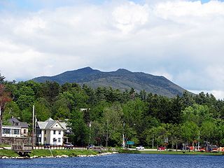
Killington Peak is the second highest summit in the Green Mountains and in the U.S. state of Vermont. It is located east of Rutland in south-central Vermont. Killington Peak is a stop on the Long Trail, which here shares its route with the Appalachian Trail. Traveling southbound on the Trail, it is the last 4,000-foot (1,200 m) peak close to the trail until Virginia.
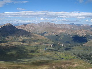
Guanella Pass is a high mountain pass in central Colorado, in the Rocky Mountains of the western United States.

Mount Spokane [elevation 5,887 feet (1,794 m)]—previously known as Mount Baldy until 1912 due to its pronounced bald spot—is a mountain in the northwest United States, located northeast of Spokane, Washington. Its summit is the highest point in Spokane County, and it is one of the tallest peaks in the Inland Northwest. Mount Spokane is surrounded by Mount Spokane State Park, Washington's largest at 13,919 acres (56.3 km2). One of the well-known features is a bald spot on the corner of the west and south parts of the mountain.

Palmer Glacier is an extinct glacier on the south slopes of Mount Hood in the U.S. state of Oregon. With glacial ice movement having stopped in the mid-1980s, it is now considered a snowfield rather than an active glacier. The former glacier, now snowfield, is situated at an elevation range of 9,300 to 6,200 feet, and was named for Joel Palmer, an Oregon pioneer. Palmer Glacier is the most well-known of the twelve glaciers on the mountain, despite no longer technically qualifying as a glacier, and is a popular destination for snowsports enthusiasts as it is the only US resort that consistently runs its chairlifts from winter through summer.

Smugglers' Notch Resort is a ski resort area in the town of Cambridge, Vermont, United States, located near the village of Jeffersonville. Its vertical drop of 2,610 feet (800 m) is the fourth largest in New England and the third largest in Vermont. Its namesake is a narrow notch running adjacent to Sterling Mountain, which smugglers used in the early 19th century. Smugglers' Notch, nicknamed Smuggs, consists of three mountains: Morse, Madonna, and Sterling. The resort attracts skiers in the winter and summer vacationers during the warmer months.

Wildcat Mountain is a mountain located in Coos County, northern New Hampshire, United States. The mountain is part of the Carter-Moriah Range of the White Mountains, on the east side of Pinkham Notch. Wildcat Mountain faces Carter Dome across Carter Notch to the northeast, and Mount Washington across Pinkham Notch to the west.

Mount Bigelow is a long mountain ridge with several summits. It is located in Franklin County and Somerset County, Maine. It is one of Maine's highest summits. The mountain is named after Major Timothy Bigelow who climbed the rugged summit in late October 1775 "for the purpose of observation." Major Bigelow was one of Colonel Benedict Arnold's four division commanders during the 1775 Invasion of Canada. The expeditionary force passed along the Dead River on the northern edge of the Bigelow Range, now dammed into Flagstaff Lake.
Mount Isolation is a mountain located in Coos County, New Hampshire. The mountain is part of the Presidential Range of the White Mountains. Mount Isolation is the highest peak on the Montalban Ridge which extends south from Boott Spur.

Jay Peak is a mountain located about 5 miles (8.0 km) south of the Canada–US border, in Jay and Westfield, Orleans County, Vermont, of which it is the highest point. Most of the mountain is in Jay State Forest. The mountain is named for the town of Jay, Vermont, in which much of the mountain except the peak area itself is located.

Stratton Mountain is a mountain located in Windham County, Vermont, in the Green Mountain National Forest. The mountain is the highest point of Windham County, and of the southern Green Mountains generally. A fire tower located on the summit is generally open for climbing by the public. There is also a small caretaker cabin at the summit that is inhabited in season by a caretaker from the Green Mountain Club. The northern end of the mountain is occupied by Stratton Mountain Resort.
Terry Peak is a mountain and ski area in the west central United States, in the Black Hills of South Dakota outside of Lead. With an elevation of 7,064 feet (2,153 m) above sea level, it is the most prominent peak in the Northern Black Hills area, and the sixth highest summit in the range; the tallest is Black Elk Peak at 7,244 feet (2,208 m).

Mount Rose is the highest mountain in Washoe County, within the Carson Range of Nevada, United States. It ranks thirty-seventh among the most topographically prominent peaks in the state. It is also both the highest and most topographically prominent peak of the greater Sierra Nevada range within the state of Nevada, and the third most topographically prominent peak in the Sierra Nevada overall. It is located in the Mount Rose Wilderness of the Humboldt-Toiyabe National Forest. An extinct volcano, the mountain is in between Lake Tahoe and Reno. State Route 431 traverses Mount Rose Summit southeast of Mount Rose. Due to the high elevation, most of the precipitation that falls on the mountain is snow. The view from Mount Rose facing east is the Truckee Meadows, the second largest population center in Nevada.
McKenzie Mountain is a 3,861-foot (1,177 m) mountain in western Essex County in the towns of St. Armand and North Elba in the Adirondack Park, a unit of the Forest Preserve.
Slide Mountain is a 9,702-foot (2,957 m) peak in the Carson Range near Reno, in Washoe County, Nevada. From the summit of Slide Mountain, Lake Tahoe, Washoe Lake, Carson Valley, and the city of Reno can be viewed.

Dixville Notch State Park is a park in northern New Hampshire, United States. The park encompasses 127 acres (51 ha) in Dixville Township where New Hampshire State Route 26 passes through Dixville Notch.
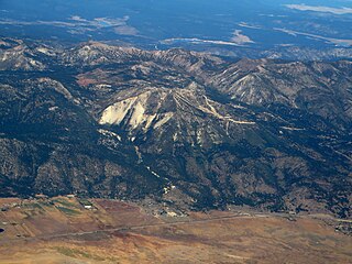
Smiley Mountain is a 11,427-foot (3,483 m) peak in Custer County, Idaho, USA, and one of the higher points in the Pioneer Mountains. It is located in the Salmon-Challis National Forest about 15 miles (24 km) west of Lost River.
