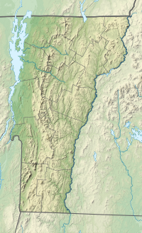
The Presidential Range is a mountain range in the Green Mountains of the U.S. state of Vermont. All of the summits of the peaks in the range are located in Addison County but the eastern slopes in the northern part of the range extend into Washington County. The major peaks in the range are named for several U.S. presidents from the period of the American Civil War through World War I.

Mount Ellen is a mountain in the Green Mountains in the U.S. state of Vermont. Located at the northern edge of the Green Mountain National Forest in Washington County, the summit of Mount Ellen is in the northwest corner of Warren but the mountain extends into Fayston to the north and Lincoln to the west. Together with Lincoln Peak to the south, the slopes of Mount Ellen are home to the Sugarbush Resort.

Mount Abraham is a mountain in the Green Mountains in the U.S. state of Vermont. Located in the Green Mountain National Forest, its summit is in the town of Lincoln in Addison County, but its eastern slopes extend into the town of Warren in Washington County. The mountain is named after Abraham Lincoln, former president of the United States. It is one of five peaks in Vermont's Presidential Range.

Dorset Mountain, on the border of Rutland and Bennington counties in Vermont, is part of the Taconic Range. The summit of Dorset Mountain is in Danby. An unmaintained hiking trail ascends from the southwest.

Pico Peak is a mountain in the Green Mountains in Rutland County, Vermont, United States. Pico Peak is flanked to the south by Ramshead Peak. To the north, it faces Deer Leap Mountain across Sherburne Pass. Seen from the pass, the summit of Pico Peak resembles a cone.

Bread Loaf Mountain is a mountain located in Addison County, Vermont, in the Breadloaf Wilderness in the Green Mountain National Forest. The mountain is part of the central Green Mountains. Bread Loaf Mountain is flanked to the northeast by Mount Wilson, part of Vermont's Presidential Range.
Mount Wilson is a mountain in the Green Mountains in the U.S. state of Vermont. Located in the Breadloaf Wilderness of the Green Mountain National Forest, its summit is in the town of Ripton in Addison County. The mountain is named after Woodrow Wilson, former president of the United States. Flanked by Bread Loaf Mountain to the southwest, Mount Wilson is one of five peaks in Vermont's Presidential Range. At 3,745 feet (1,141 m), it is the 12th highest peak in Vermont and one of the hundred highest peaks in New England.

Jay Peak is a mountain located about 5 miles (8.0 km) south of the Canada–US border, in Jay and Westfield, Orleans County, Vermont, of which it is the highest point. Most of the mountain is in Jay State Forest. The mountain is named for the town of Jay, Vermont, in which much of the mountain except the peak area itself is located.
Lincoln Peak is a mountain located on the border between Addison and Washington counties in the U.S. state of Vermont. It is part of the Lincoln Mountain section of the Green Mountains in the Green Mountain National Forest. Lincoln Peak is flanked to the southwest by Mount Abraham, and to the north by Nancy Hanks Peak, which was named after Abraham Lincoln's mother, Nancy Lincoln.
Glastenbury Mountain is a mountain located in Bennington County, Vermont, in the Green Mountain National Forest. The mountain is part of the Green Mountains.
Lincoln Gap is a mountain pass in the Green Mountains of the U.S. state of Vermont. The highest point of the gap is located in the town of Lincoln in Addison County approximately 0.5 miles (0.8 km) west of the boundary between Lincoln and the town of Warren in Washington County.

The Appalachian Gap is a mountain pass in the Green Mountains of Vermont. The highest point of the pass is located in Chittenden County, about 0.2 mi (0.32 km) west of the boundary between Chittenden and Washington County. The pass is in the Camel's Hump State Park.
Shrewsbury Peak is a mountain located in Rutland County, Vermont, in the Calvin Coolidge State Forest. The mountain is part of the Coolidge Range. Shrewsbury is flanked to the northwest by Little Killington.
Bolton Mountain is a mountain located in Chittenden County, Vermont. Bolton is flanked to the north by Mount Mayo.
Middlebury Gap, is a mountain pass in the Green Mountains of Vermont. The height of land of the pass is located in Addison County.

Sherburne Pass, is a mountain pass in the Green Mountains of Vermont, between 3,957-foot (1,206 m) Pico Peak to the south and 2,782-foot (848 m) Deer Leap Mountain to the north. The height of land of the pass is located in the town of Killington, while its western ascent begins in the town of Mendon.
Stark Mountain is a mountain in the Green Mountains in the U.S. state of Vermont. Located in the town of Fayston in Washington County, the mountain summit is 3,662 feet (1,116 m) in elevation. Stark Mountain is named after General John Stark, hero of the Battle of Bennington fought in 1777.
The Breadloaf Wilderness is one of eight wilderness areas in the Green Mountain National Forest in the U.S. state of Vermont. It was created by the Vermont Wilderness Act of 1984 and later expanded by the New England Wilderness Act of 2006. With a total of 24,986 acres (10,111 ha), it is the largest wilderness area in Vermont. The area is managed by the U.S. Forest Service.
Mount Cleveland is a mountain in the Green Mountains in the U.S. state of Vermont. Located in the Breadloaf Wilderness of the Green Mountain National Forest, its summit is in the town of Lincoln in Addison County. The mountain is named after Grover Cleveland, former president of the United States. Mount Cleveland is one of five peaks in Vermont's Presidential Range.
Mount Roosevelt is a mountain in the Green Mountains in the U.S. state of Vermont. Located in the Breadloaf Wilderness of the Green Mountain National Forest, its summit is in the town of Ripton in Addison County. The mountain is named after Theodore Roosevelt, former president of the United States. Mount Roosevelt is one of five peaks in Vermont's Presidential Range.