Moretown, Vermont

Last updated
Moretown, Vermont
MoretownVT TownHall.jpg
Washington County Vermont Incorporated and Unincorporated areas Moretown highlighted.svg
Location in Washington County and the state of Vermont
Usa edcp location map.svg
Red pog.svg
Moretown, Vermont
Location in the United States
Coordinates: 44°15′59″N72°43′32″W / 44.26639°N 72.72556°W / 44.26639; -72.72556 Coordinates: 44°15′59″N72°43′32″W / 44.26639°N 72.72556°W / 44.26639; -72.72556
Country United States
State Vermont
County Washington
Area
  Total40.2 sq mi (104.2 km2)
  Land39.9 sq mi (103.3 km2)
  Water0.3 sq mi (0.8 km2)
Elevation
1,083 ft (330 m)
Population
 (2020)
  Total1,753
  Density44/sq mi (17/km2)
Time zone UTC-5 (Eastern (EST))
  Summer (DST) UTC-4 (EDT)
ZIP code
05660
Area code 802
FIPS code 50-46225 [1]
GNIS feature ID1462153 [2]
Website www.moretownvt.org

Moretown is a town in Washington County, Vermont, United States. The population was 1,753 at the 2020 census. [3]

Contents

History

Moretown Village was devastated in 2011 by Hurricane Irene. More than 60 homes and buildings flooded, including the post office, the town offices, the church, the school and the fire station. [4]

In 1913, 125 acres were purchased in North Moretown and a talc processing facility was built. To this day, the old structure remains a town landmark in disrepair. [5]

Geography

According to the United States Census Bureau, the town has a total area of 40.2 square miles (104.2 km2), of which 39.9 square miles (103.3 km2) is land and 0.31 square miles (0.8 km2), or 0.81%, is water. [6]

Demographics

Historical population
CensusPop.
1800 191
1810 405112.0%
1820 59346.4%
1830 81637.6%
1840 1,12838.2%
1850 1,33518.4%
1860 1,4105.6%
1870 1,263−10.4%
1880 1,180−6.6%
1890 956−19.0%
1900 902−5.6%
1910 686−23.9%
1920 93035.6%
1930 889−4.4%
1940 675−24.1%
1950 88330.8%
1960 788−10.8%
1970 90414.7%
1980 1,22135.1%
1990 1,41515.9%
2000 1,65316.8%
2010 1,6580.3%
2020 1,7535.7%
U.S. Decennial Census [7] [8]

As of the census [1] of 2000, there were 1,653 people, 650 households, and 436 families residing in the town. The population density was 41.2 people per square mile (15.9/km2). There were 727 housing units at an average density of 18.1 per square mile (7.0/km2). The racial makeup of the town was 98.19% White, 0.12% Native American, 0.79% Asian, 0.12% from other races, and 0.79% from two or more races. Hispanic or Latino of any race were 0.67% of the population.

There were 650 households, out of which 35.7% had children under the age of 18 living with them, 55.1% were married couples living together, 8.6% had a female householder with no husband present, and 32.8% were non-families. 22.3% of all households were made up of individuals, and 7.7% had someone living alone who was 65 years of age or older. The average household size was 2.54 and the average family size was 3.01.

In the town, the population was spread out, with 26.6% under the age of 18, 5.2% from 18 to 24, 31.8% from 25 to 44, 27.0% from 45 to 64, and 9.4% who were 65 years of age or older. The median age was 38 years. For every 100 females, there were 99.6 males. For every 100 females age 18 and over, there were 97.2 males.

The median income for a household in the town was $47,750, and the median income for a family was $52,202. Males had a median income of $35,270 versus $26,719 for females. The per capita income for the town was $20,283. About 5.4% of families and 6.6% of the population were below the poverty line, including 5.6% of those under age 18 and 7.9% of those age 65 or over.

A creek near Moretown Common. MoretownCreek.jpg
A creek near Moretown Common.
Camel's Hump viewed from Moretown in autumn. CamelsHump.jpg
Camel's Hump viewed from Moretown in autumn.

Economy

Moretown has one retail store, The Moretown General Store, which serves as a gas station, convenience store and delicatessen. The Moretown general store is the center of the town, which often serves as a meeting place and is in many ways a community center.

Moretown is also home to many successful entrepreneurs in fields such as real estate, carpentry, baking, plumbing, and other trades; however, most residents commute to work in other towns with larger economies such as Montpelier and Burlington.

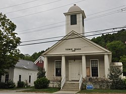
Moretown also has several small farms, a clapboard mill, three churches, one elementary school, a small library, and a town hall.

Notable people

Related Research Articles

<span class="mw-page-title-main">Cornwall, Vermont</span> Town in Vermont, United States

Cornwall is a town in Addison County, Vermont, United States. It was founded November 3, 1761. The population was 1,207 at the 2020 census.

<span class="mw-page-title-main">New Haven, Vermont</span> Town in Vermont, United States

New Haven is a town in Addison County, Vermont, United States. The population was 1,683 at the 2020 census. In addition to the town center, New Haven contains the communities of Belden, Brooksville, New Haven Junction and New Haven Mills.

<span class="mw-page-title-main">Whiting, Vermont</span> Town in Vermont, United States

Whiting is a town in Addison County, Vermont, United States. The town was named for John Whiting, a landholder. The population was 405 at the 2020 census.

<span class="mw-page-title-main">Sandgate, Vermont</span> Town in Vermont, United States

Sandgate is a town in Bennington County, Vermont, United States. The population was 387 at the 2020 census.

<span class="mw-page-title-main">Berkshire, Vermont</span> Town in Vermont, United States

Berkshire is a town in Franklin County, Vermont, United States. The population was 1,547 at the 2020 census. It contains the unincorporated village of East Berkshire.

<span class="mw-page-title-main">Franklin, Vermont</span> Town in Vermont, United States

Franklin is a town in Franklin County, Vermont, United States. The population was 1,363 at the 2020 census. The original name was "Huntsburgh", but the name was changed to "Franklin" in 1817.

<span class="mw-page-title-main">Sheldon, Vermont</span> Town in Vermont, United States

Sheldon is a town in Franklin County, Vermont, United States. The population was 2,136 at the 2020 census. It contains the unincorporated community of Sheldon Springs.

<span class="mw-page-title-main">Williamstown, Vermont</span> Town in Vermont, United States

Williamstown is a town in Orange County, Vermont, United States. The population was 3,515 at the 2020 census, making it the second largest municipality in the county.

<span class="mw-page-title-main">Westfield, Vermont</span> Town in Vermont, United States

Westfield is a town in Orleans County, Vermont United States. The population was 534 at the 2020 census. The town was founded in 1780 and named after Rhode Island general and politician, William West, a supporter of Vermont statehood.

<span class="mw-page-title-main">Mount Holly, Vermont</span> Town in Vermont, United States

Mount Holly is a town in Rutland County, Vermont, United States. It includes the hamlets of Belmont, Healdville, Hortonville, and Tarbellville. The population was 1,385 at the 2020 census.

<span class="mw-page-title-main">Halifax, Vermont</span> Town in Vermont, United States

Halifax is a town in Windham County, Vermont, in the United States. As of the 2020 census, the town population was 771.

<span class="mw-page-title-main">Andover, Vermont</span> Town in Vermont, United States

Andover is a town in Windsor County, Vermont, United States. The population was 568 at the 2020 census.

<span class="mw-page-title-main">Plymouth, Vermont</span> Town in Vermont, United States

Plymouth is a town in Windsor County, Vermont, United States. The population was 641 at the 2020 census. Calvin Coolidge, the 30th President of the United States, was born and raised in Plymouth and is buried there as well. The State of Vermont Division for Historic Preservation owns and maintains the Coolidge Homestead and the village of Plymouth Notch.

<span class="mw-page-title-main">Vermont, Wisconsin</span> Town in Wisconsin, United States

Vermont is a town in Dane County, Wisconsin, United States. The population was 871 at the 2020 census. The unincorporated communities of Elvers and Vermont are located in the town.

<span class="mw-page-title-main">Milford, Wisconsin</span> Town in Wisconsin, United States

Milford is a town in Jefferson County, Wisconsin, United States. The population was 1,099 at the 2010 census. The unincorporated communities of Grellton, Hoopers Mill, Hubbleton, and Milford are located in the town.

<span class="mw-page-title-main">Cady, Wisconsin</span> Town in Wisconsin, United States

Cady is a town in St. Croix County, Wisconsin, United States. The population was 710 at the 2000 census. The unincorporated community of Hatchville is located partially in the town.

<span class="mw-page-title-main">Marshfield, Vermont</span> Town in Vermont, United States

Marshfield is a town in Washington County, Vermont, United States. The population was 1,583 at the 2020 census.

<span class="mw-page-title-main">Westminster (town), Vermont</span> Town in Vermont, United States

Westminster is a town in Windham County, Vermont, United States. The population was 3,016 at the 2020 census. It is also the first capital of the Republic of Vermont. It borders the state of New Hampshire.

<span class="mw-page-title-main">Wyocena, Wisconsin</span> Village in Wisconsin, United States

Wyocena is a village in Columbia County, Wisconsin, United States. The population was 768 at the 2010 census. The village is located within the Town of Wyocena. It is part of the Madison Metropolitan Statistical Area.

<span class="mw-page-title-main">Windsor, Wisconsin</span> Village in Wisconsin, United States

Windsor is a village and former town in Dane County, Wisconsin. The population was 8,754 at the time of the 2020 census. The communities of Lake Windsor, Morrisonville, and Token Creek are located within the village. Windsor voted to incorporate as a village on November 3, 2015; prior to its incorporation, it was a town, and a portion of the town was a census-designated place. Windsor is a part of the Census Bureau's Madison metropolitan statistical area.

References

  1. 1 2 "U.S. Census website". United States Census Bureau . Retrieved 2008-01-31.
  2. "US Board on Geographic Names". United States Geological Survey. 2007-10-25. Retrieved 2008-01-31.
  3. "Profile of General Population and Housing Characteristics: 2020 Demographic Profile Data (DP-1): Moretown town, Washington County, Vermont". United States Census Bureau . Retrieved December 9, 2021.
  4. "PHOTOS: TS Irene hits Moretown Vermont". Valleyreporter.com. Retrieved 2016-10-01.
  5. "MORETOWN HISTORICAL SOCIETY NEWSLETTER" (PDF). Moretownvt.org. January 2014. Retrieved 7 September 2018.
  6. "Geographic Identifiers: 2010 Demographic Profile Data (G001): Moretown town, Washington County, Vermont". United States Census Bureau . Retrieved September 18, 2012.
  7. "Census of Population and Housing". Census.gov. Retrieved June 4, 2015.
  8. "Vermont History Explorer". Vermonthistory.org. Retrieved August 7, 2015.
  9. 'Wisconsin Blue Book 1874,' Biographical Sketch of Harvey Clapp, pg. 467