South Barre, Vermont

Last updated

South Barre, Vermont
CDP
Washington County Vermont Incorporated and Unincorporated areas South Barre highlighted.svg
Location in Washington County and the state of Vermont
Coordinates: 44°10′0″N72°30′9″W / 44.16667°N 72.50250°W / 44.16667; -72.50250
Country United States
State Vermont
County Washington
Area
  Total2.1 sq mi (5.4 km2)
  Land2.1 sq mi (5.4 km2)
  Water0.0 sq mi (0.0 km2)
Elevation
738 ft (225 m)
Population
 (2000)
  Total1,242
  Density593.3/sq mi (229.1/km2)
Time zone UTC-5 (Eastern (EST))
  Summer (DST) UTC-4 (EDT)
ZIP code
05670
Area code 802
FIPS code 50-66025 [1]
GNIS feature ID1459567 [2]

South Barre is a census-designated place (CDP) in the town of Barre in Washington County, Vermont, United States. The population was 1,242 at the 2000 census.

Contents

Geography

According to the United States Census Bureau, the CDP has a total area of 5.4 km2 (2.1 mi2), all land.

Demographics

As of the census [1] of 2000, there were 1,242 people, 534 households, and 367 families residing in the CDP. The population density was 229.4/km2 (593.3/mi2). There were 553 housing units at an average density of 102.2/km2 (264.1/mi2). The racial makeup of the CDP was 98.87% White, 0.24% African American, 0.24% Asian, 0.08% from other races, and 0.56% from two or more races. Hispanic or Latino of any race were 2.74% of the population.

There were 534 households, out of which 28.5% had children under the age of 18 living with them, 57.7% were married couples living together, 7.9% had a female householder with no husband present, and 31.1% were non-families. 26.8% of all households were made up of individuals, and 10.3% had someone living alone who was 65 years of age or older. The average household size was 2.33 and the average family size was 2.78.

In the CDP, the population was spread out, with 21.7% under the age of 18, 6.6% from 18 to 24, 26.0% from 25 to 44, 30.3% from 45 to 64, and 15.5% who were 65 years of age or older. The median age was 42 years. For every 100 females, there were 93.5 males. For every 100 females age 18 and over, there were 91.5 males.

The median income for a household in the CDP was $38,750, and the median income for a family was $50,625. Males had a median income of $32,167 versus $22,974 for females. The per capita income for the CDP was $23,480. About 2.9% of families and 5.7% of the population were below the poverty line, including 4.8% of those under age 18 and 3.1% of those age 65 or over.

Climate

This climatic region is typified by large seasonal temperature differences, with warm to hot (and often humid) summers and cold (sometimes severely cold) winters. According to the Köppen Climate Classification system, South Barre has a humid continental climate, abbreviated "Dfb" on climate maps. [3]

Related Research Articles

<span class="mw-page-title-main">Sunnyside–Tahoe City, California</span> Census-designated place in California, United States

Sunnyside–Tahoe City is a census-designated place (CDP) in Placer County, California, located on the northwest shore of Lake Tahoe. The population was 1,557 at the 2010 census, down from 1,761 at the 2000 census, and a total area of 3.4 sq mi (8.8 km2), all of it land. It comprises two communities, Sunnyside, and Tahoe City.

<span class="mw-page-title-main">Babson Park, Florida</span> Census-designated place in Florida, United States

Babson Park is a census-designated place (CDP) in Polk County, Florida, United States. The population was 1,182 at the 2000 census. It is also the home of Webber International University.

<span class="mw-page-title-main">Perryman, Maryland</span> Census-designated place in Maryland, United States

Perryman is an unincorporated community and census-designated place (CDP) in Harford County, Maryland, United States. The population was 2,342 at the 2010 census.

<span class="mw-page-title-main">Chance, Maryland</span> CDP in Maryland, United States

Chance is a census-designated place (CDP) in Somerset County, Maryland, United States. The population was 377 at the 2000 census. It is included in the Salisbury, Maryland-Delaware Metropolitan Statistical Area.

<span class="mw-page-title-main">Ravalli, Montana</span> Place in Montana, United States

Ravalli is an unincorporated community in Lake County, Montana, United States. The population was 76 at the 2010 census, down from 119 in 2000. For statistical purposes, the United States Census Bureau has defined Saticoy as a census-designated place (CDP). In the early 1900s, the Pablo-Allard herd in Ravalli was said to be the largest collection of the bison remaining in the U.S. and played a critical role in the conservation of bison.

<span class="mw-page-title-main">Elliston, Montana</span> CDP in Montana, United States

Elliston is a census-designated place (CDP) in Powell County, Montana, United States. The population was 225 at the 2000 census.

<span class="mw-page-title-main">Aquebogue, New York</span> Hamlet and census-designated place in New York, United States

Aquebogue is a census-designated place (CDP) roughly corresponding to the hamlet by the same name in the Town of Riverhead in Suffolk County, on Long Island, in New York, United States. The CDP's population was 2,438 at the 2010 census.

<span class="mw-page-title-main">Westhampton, New York</span> Hamlet and census-designated place in New York, United States

Westhampton is a hamlet and census-designated place (CDP) in Suffolk County, New York, United States. The population was 3,079 at the 2010 census.

<span class="mw-page-title-main">Knippa, Texas</span> Census-designated place in Texas, United States

Knippa is a census-designated place (CDP) in Uvalde County, Texas, United States. The population was 689 at the 2010 census.

<span class="mw-page-title-main">Serenada, Texas</span> CDP in Texas, United States

Serenada is a census-designated place (CDP) in Williamson County, Texas, United States. The population was 1,641 at the 2010 census. Those living in Serenada have Georgetown addresses.

<span class="mw-page-title-main">Manchester Center, Vermont</span> Census-designated place in Vermont, United States

Manchester Center is a census-designated place (CDP) in the town of Manchester in Bennington County, Vermont, United States. As of the 2010 census, the CDP had a population of 2,120, out of 4,391 people in the entire town of Manchester.

<span class="mw-page-title-main">Enosburg Falls, Vermont</span> Village in Vermont, United States

Enosburg Falls is a village in the town of Enosburgh in Franklin County, Vermont, in the United States. The population was 1,356 at the 2020 census.

<span class="mw-page-title-main">Jacksonville, Vermont</span> Village in Vermont, United States

Jacksonville is a village in the town of Whitingham, Windham County, Vermont, United States. The population was 213 at the 2020 census.

<span class="mw-page-title-main">Collinsville, Virginia</span> CDP in Virginia, United States

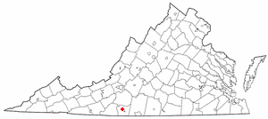
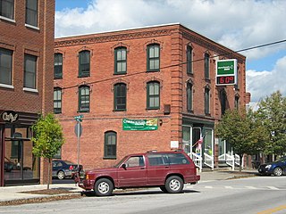
Collinsville is a census-designated place (CDP) in Henry County, Virginia, United States. The population was 7,335 at the 2010 census, which was down from the 7,777 reported in 2000. It is part of the Martinsville Micropolitan Statistical Area. Collinsville is also where the administration building and county courthouse of Henry County are located.

<span class="mw-page-title-main">Wiley Ford, West Virginia</span> CDP in West Virginia, United States

Wiley Ford is a census-designated place (CDP) in Mineral County, West Virginia, United States and part of the 'Cumberland, MD-WV Metropolitan Statistical Area'. The population was 1,026 at the 2010 census.

<span class="mw-page-title-main">Boaz, West Virginia</span> CDP in West Virginia, United States

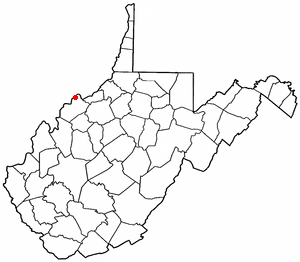
Boaz is a census-designated place (CDP) in Wood County, West Virginia, United States. It is part of the Parkersburg-Marietta-Vienna, WV-OH Metropolitan Statistical Area. As of the 2020 census, the CDP population was 1,321.

Hollins is a census-designated place (CDP) in Botetourt and Roanoke counties in the U.S. state of Virginia. Hollins covers much of the area known locally as "North County". The population was 15,574 at the 2020 census. It is part of the Roanoke Metropolitan Statistical Area. The area is also the home of Hollins University in addition to four properties listed on the National Register of Historic Places: the Black Horse Tavern-Bellvue Hotel and Office, Harshbarger House, the Hollins College Quadrangle, and Old Tombstone.

<span class="mw-page-title-main">Barre (CDP), Massachusetts</span> CDP in Massachusetts, United States

Barre is a census-designated place (CDP) in the town of Barre in Worcester County, Massachusetts, United States. The population was 1,009 at the 2010 census.

<span class="mw-page-title-main">Barre (town), Vermont</span> Town in Vermont, United States

Barre is a town in Washington County, Vermont, United States. The population was 7,923 at the 2020 census, making it the 3rd largest municipality in Washington County and the 16th largest municipality in Vermont. Popularly referred to as "Barre Town", the town of Barre almost completely surrounds "Barre City", which is a separate municipality. The original town now known as Barre was first chartered in 1780 as the Town of Wildersburgh. In 1793 the name Wildersburgh was unpopular with the inhabitants and the name of the town was changed to Barre. In 1895 the City of Barre was incorporated and separated from the town of Barre, and both continue to exist as separate municipalities.

<span class="mw-page-title-main">West Rutland, Vermont</span> Town in Vermont, United States

West Rutland is a town in Rutland County, Vermont, United States. The population was 2,214 at the 2020 census. The town center, located in the south-central portion of the town and where about 87% of the population resides, is defined by the U.S. Census Bureau as a census-designated place (CDP). The town is part of the Rutland micropolitan NECTA.

References

  1. 1 2 "U.S. Census website". United States Census Bureau . Retrieved January 31, 2008.
  2. "US Board on Geographic Names". United States Geological Survey. October 25, 2007. Retrieved January 31, 2008.
  3. Climate Summary for South Barre, Vermont

44°10′37″N72°30′20″W / 44.17694°N 72.50556°W / 44.17694; -72.50556