Groton, Vermont

Last updated

Groton, Vermont
Looking down Scott Highway, Groton, Vermont.jpg
Houses along Scott Highway
Groton vt highlight.png
Groton, Vermont
Usa edcp location map.svg
Red pog.svg
Groton, Vermont
Location in the United States
Coordinates: 44°14′24″N72°14′20″W / 44.24000°N 72.23889°W / 44.24000; -72.23889
Country United States
State Vermont
County Caledonia
Communities Groton
Ricker Mills
West Groton
Area
  Total55.0 sq mi (142.4 km2)
  Land53.7 sq mi (139.2 km2)
  Water1.2 sq mi (3.1 km2)
Elevation
1,106 ft (337 m)
Population
 (2020)
  Total984
  Density18/sq mi (7.1/km2)
Time zone UTC-5 (Eastern (EST))
  Summer (DST) UTC-4 (EDT)
ZIP code
05046
Area code 802
FIPS code 50-30550 [1]
GNIS feature ID1462110 [2]
Website www.grotonvt.com

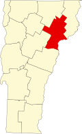
Groton is a town in Caledonia County, Vermont, United States. The population was 984 at the 2020 census. [3] It contains the places Groton Pond, Rickers Mills, Rickers and West Groton. The unincorporated village of Groton in the southeast corner of town is recorded as the Groton census-designated place (CDP), with a population of 419 at the 2020 census. [4]

Contents

History

Some say the town was named after Groton, Massachusetts, while others believe it was named after Groton, Connecticut. [5]

Geography

Groton, Vermont
Groton, Vermont Post Office.jpg
Post Office
Groton United Methodist Church, Vermont.jpg
Methodist Church
Groton (Vermont) Town Park.jpg
Town Park

Groton is located in the southwest corner of Caledonia County. It is bordered by the town of Peacham to the north, Barnet to the northeast, and Ryegate to the east, all in Caledonia County. To the south, in Orange County, are the towns of Newbury (southeast), Topsham (south), and Orange (southwest). The Washington County towns of Plainfield and Marshfield are to the west. According to the United States Census Bureau, the town has a total area of 142.4 square kilometres (55.0 sq mi), of which 139.2 square kilometres (53.7 sq mi) is land and 1.2 square miles (3.1 km2), or 2.19%, is water. [6]

The Wells River, a tributary of the Connecticut River, has its headwaters in Groton. [7] Groton State Forest occupies most of the western third of the town. The highest point in Groton is 3,352-foot (1,022 m) Signal Mountain, near the southwest corner of the town.

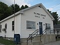
The CDP of Groton is the primary settlement in the town, located in the southeastern corner along US 302 and the Wells River. It has a total area of 2.07 square miles (5.36 km2), of which 2.05 square miles (5.31 km2) is land and 0.023 square miles (0.06 km2), or 1.03%, is water. [8]

Demographics

Historical population
CensusPop.Note
1790 45
1800 248451.1%
1810 44981.0%
1820 59532.5%
1830 83640.5%
1840 92811.0%
1850 895−3.6%
1860 9394.9%
1870 811−13.6%
1880 1,01425.0%
1890 1,0402.6%
1900 1,0591.8%
1910 915−13.6%
1920 902−1.4%
1930 803−11.0%
1940 764−4.9%
1950 712−6.8%
1960 631−11.4%
1970 6665.5%
1980 6670.2%
1990 86229.2%
2000 8761.6%
2010 1,02216.7%
2020 984−3.7%
U.S. Decennial Census [9]

As of the census [1] of 2000, there were 876 people, 338 households, and 252 families residing in the town. The population density was 16.2 people per square mile (6.3/km2). There were 586 housing units at an average density of 10.9 per square mile (4.2/km2). The racial makeup of the town was 96.46% White, 1.26% Native American, 0.23% from other races, and 2.05% from two or more races. Hispanic or Latino of any race were 0.34% of the population.

There were 338 households, out of which 35.8% had children under the age of 18 living with them, 61.8% were couples living together and joined in either marriage or civil union, 9.5% had a female householder with no husband present, and 25.4% were non-families. 20.1% of all households were made up of individuals, and 9.8% had someone living alone who was 65 years of age or older. The average household size was 2.59 and the average family size was 2.99.

In the town, the population was spread out, with 28.3% under the age of 18, 5.4% from 18 to 24, 25.8% from 25 to 44, 25.9% from 45 to 64, and 14.6% who were 65 years of age or older. The median age was 39 years. For every 100 females, there were 86.4 males. For every 100 females age 18 and over, there were 86.9 males.

The median income for a household in the town was $33,333, and the median income for a family was $36,719. Males had a median income of $28,750 versus $18,269 for females. The per capita income for the town was $14,659. Below the poverty line were 10.5% of people, 6.8% of families, 11.9% of those under 18 and 9.1% of those over 64.

Infrastructure

Roads

Groton on US302 Groton VT CDP on US302.jpg
Groton on US302
The sign for Groton on US302 Groton VT Sign US302.jpg
The sign for Groton on US302

Recreation

Groton is home to five state parks in Groton State Forest: Big Deer State Park, Boulder Beach State Park, Ricker Pond State Park, Seyon Lodge State Park and Stillwater State Park, as well as the Groton Nature Center. Activities in the parks include hiking, camping, fishing, swimming, boating, picnicking, snowshoeing and cross country skiing.

The Groton Fall Festival and the Fall Foliage Chicken Pie are annual traditions. [10] [11]

Notable people

Related Research Articles

<span class="mw-page-title-main">Washington County, Vermont</span> County in Vermont, United States

Washington County is a county located in the U.S. state of Vermont. Named after George Washington, its shire town is the city of Montpelier and the most populous municipality is the city of Barre. As of the 2020 census, the population was 59,807, making it the third-most populous county in Vermont, but the third-least populous capital county in the United States after Hughes County, South Dakota and Franklin County, Kentucky. Washington County comprises the Barre, Vermont micropolitan statistical area. In 2010, the center of population of Vermont was located in Washington County, in the town of Warren.

<span class="mw-page-title-main">Caledonia County, Vermont</span> County in Vermont, United States

Caledonia County is a county located in the northeastern part of the U.S. state of Vermont. As of the 2020 census, the population was 30,233. Its shire town is the town of St. Johnsbury. The county was created in 1792 and organized in 1796. It was given the Latin name for Scotland, in honor of the many settlers who claimed ancestry there.

<span class="mw-page-title-main">Woodsville, New Hampshire</span> Census-designated place in New Hampshire, United States

Woodsville is a census-designated place (CDP) and the largest village in the town of Haverhill in Grafton County, New Hampshire, United States, along the Connecticut River at the mouth of the Ammonoosuc River. The population was 1,431 at the 2020 census. Although North Haverhill is now the county seat of Grafton County, the village of Woodsville has traditionally been considered the county seat, as the county courthouse was originally located there. The county buildings are now located halfway between Woodsville and the village of North Haverhill to the south.

Cortland West is a census-designated place and region in Cortland County, New York, United States. The population was 1,356 at the 2010 census.

<span class="mw-page-title-main">Barnet, Vermont</span> Town in Vermont, United States

Barnet is a town in Caledonia County, Vermont, United States. The population was 1,663 at the 2020 census. Barnet contains the locations of Barnet Center, East Barnet, McIndoe Falls, Mosquitoville, Passumpsic and West Barnet. The main settlement of Barnet is recorded as a census-designated place by the U.S. Census Bureau, with a population of 127 at the 2020 census.

<span class="mw-page-title-main">Danville, Vermont</span> Town in Vermont, United States

Danville is a town in Caledonia County, Vermont, United States. The population was 2,335 at the 2020 census. The primary settlement in town is recorded as the Danville census-designated place (CDP) and had a population of 385 at the 2020 census.

<span class="mw-page-title-main">Hardwick, Vermont</span> Town in Vermont, United States

Hardwick is a town in Caledonia County, Vermont, United States. The population was 2,920 at the 2020 census. It contains the unincorporated villages of Hardwick, East Hardwick, and Mackville. The town is a commercial center for the region's farming population.

<span class="mw-page-title-main">Kirby, Vermont</span> Town in Vermont, United States

Kirby is a town in Caledonia County, Vermont, United States. The population was 575 at the 2020 census.

<span class="mw-page-title-main">Newark, Vermont</span> Town in Vermont, United States

Newark is a town in Caledonia County, Vermont, United States. The population was 584 at the 2020 census.

<span class="mw-page-title-main">Peacham, Vermont</span> Town in Vermont, United States

Peacham is a town in Caledonia County, Vermont, United States. The population was 715 at the 2020 census.

<span class="mw-page-title-main">Ryegate, Vermont</span> Town in Vermont, United States

Ryegate is a town in Caledonia County, Vermont, United States. The population was 1,165 at the 2020 census. The town contains the villages of South Ryegate, East Ryegate, and Ryegate Corner.

<span class="mw-page-title-main">Sheffield, Vermont</span> Town in Vermont, United States

Sheffield is a town in Caledonia County, Vermont, United States. The population was 682 at the 2020 census.

<span class="mw-page-title-main">Waterford, Vermont</span> Town in Vermont, United States

Waterford is a town in Caledonia County, Vermont, United States. The population was 1,268 at the 2020 census.

<span class="mw-page-title-main">Elmore, Vermont</span> Town in Vermont, United States

Elmore is a town in Lamoille County, Vermont, United States. It was granted by the Vermont Republic in 1780, and was named for Colonel Samuel Elmore (1720–1805), one of the original grantees. The population was 886 at the 2020 census. Elmore contains the villages of East Elmore and Lake Elmore, as well as Elmore State Park, a 700-acre (2.8 km2) recreational area on the 219-acre (0.9 km2) Lake Elmore and on Elmore Mountain to the west.

<span class="mw-page-title-main">East Montpelier, Vermont</span> Town in Vermont, United States

East Montpelier is a town in Washington County, Vermont, United States. The population was 2,598 at the 2020 census.

<span class="mw-page-title-main">Marshfield, Vermont</span> Town in Vermont, United States

Marshfield is a town in Washington County, Vermont, United States. The population was 1,583 at the 2020 census.

<span class="mw-page-title-main">St. Johnsbury, Vermont</span> Town in Vermont, United States

St. Johnsbury is the shire town of Caledonia County, Vermont, United States. As of the 2020 census, the population was 7,364. St. Johnsbury is situated on the Passumpsic River and is located approximately six miles northwest of the Connecticut River and 48 miles (77 km) south of the Canada–U.S. border.

<span class="mw-page-title-main">Groton (CDP), Massachusetts</span> Census-designated place in Massachusetts, United States

Groton is a census-designated place (CDP) comprising the main village in the town of Groton in Middlesex County, Massachusetts, United States. The population of the CDP was 1,353 at the 2020 census, out of 11,315 in the entire town of Groton.

Groton is the primary village and a census-designated place (CDP) in the town of Groton, Caledonia County, Vermont, United States. As of the 2020 census, the CDP had a population of 419, out of 984 in the entire town of Groton.

Peacham is the primary village and a census-designated place (CDP) in the town of Peacham, Caledonia County, Vermont, United States. It was first listed as a CDP prior to the 2020 census. The Peacham Corner Historic District, listed on the National Register of Historic Places, occupies the four roads extending outward from the crossroads at the village center.

References

  1. 1 2 "U.S. Census website". United States Census Bureau . Retrieved January 31, 2008.
  2. "US Board on Geographic Names". United States Geological Survey. October 25, 2007. Retrieved January 31, 2008.
  3. "Census - Geography Profile: Groton town, Caledonia County, Vermont". United States Census Bureau . Retrieved December 30, 2021.
  4. "Census - Geography Profile: Groton CDP, Vermont". United States Census Bureau . Retrieved December 30, 2021.
  5. Kimball, Carol W. (July 28, 2004). "Groton is the name of choice for several communities". The Day. pp. B4. Retrieved October 31, 2015.
  6. "Geographic Identifiers: 2010 Demographic Profile Data (G001): Groton town, Caledonia County, Vermont". U.S. Census Bureau, American Factfinder. Archived from the original on February 12, 2020. Retrieved February 4, 2013.
  7. DeLorme (1996). Vermont Atlas & Gazetteer. Yarmouth, Maine: DeLorme. ISBN   0-89933-016-9
  8. "Geographic Identifiers: 2010 Demographic Profile Data (G001): Groton CDP, Vermont". U.S. Census Bureau, American Factfinder. Archived from the original on February 12, 2020. Retrieved February 6, 2013.
  9. "U.S. Decennial Census". United States Census Bureau. Retrieved May 16, 2015.
  10. "Groton Fall Foliage Festival". Groton, Vermont. Retrieved July 22, 2016.
  11. "Preparing a chicken pie supper for the whole community". WCAX.com. October 4, 2014. Retrieved July 22, 2016.
  12. McGuire, Eric (Summer 2011). "Wm. Warburton alias "Bristol Bill"" (PDF). Groton Historical Society Newsletter. Groton, VT. p. 1.
  13. Vermont Historical Society. "William Scott Letters". Vermont Historical Society. Retrieved October 11, 2017.