McIndoe Falls, Vermont

Last updated

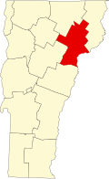
McIndoe Falls [1] is an unincorporated community within the town of Barnet, Vermont, in the United States. It is located in the southeastern corner of Barnet, along the Connecticut River, the state boundary with New Hampshire. A dam on the Connecticut River at the village forms the McIndoes Reservoir, which extends upstream to the village of Barnet.

U.S. Route 5 passes north–south through the village. Interstate 91 bypasses the village to the west, with the nearest access being Exit 18 (Barnet), 3 miles (5 km) to the north. McIndoes Falls Road leads east from the center of the village across the Connecticut River to the town of Monroe, New Hampshire. The next river crossing upstream is 2 miles (3 km) to the north near Barnet village, and the next crossing downstream is 8 miles (13 km) south where U.S. Route 302 crosses between Wells River, Vermont, and Woodsville, New Hampshire.

McIndoe Falls has a separate ZIP code (05050) from the rest of Barnet.

McIndoe Falls was also referred to as McIndoes or McIndoes Falls. [2] [3] The historic McIndoes Academy building is in the village. An 1875 map shows McIndoes Falls. [4] The post office established in 1885 was named McIndoes Falls. [5]

Related Research Articles

Caledonia County, Vermont U.S. county in Vermont

Caledonia County is a county located in the northeastern part of the U.S. state of Vermont. As of the 2010 census, the population was 31,227. Its shire town is the town of St. Johnsbury. The county was created in 1792 and organized in 1796. It was given the Latin name for Scotland, in honor of the many settlers who claimed ancestry there.

Interstate 91 (I-91) is an Interstate Highway in the New England region of the United States. It provides the primary north–south thoroughfare in the western part of the region. The Interstate generally follows the course of the Connecticut River. Its southern end is in New Haven, Connecticut, at Interstate 95. The northern end of the American-maintained road is in the village of Derby Line, Vermont, at the Canadian border. I-91 then continues past the Derby Line–Rock Island Border Crossing, where the road's official name changes to Autoroute 55. I-91 is the longest of three Interstate highways whose entire route is located within the New England states and is also the only primary (two-digit) Interstate Highway in New England to intersect all five of the others that run through the region. The largest cities along its route are New Haven, Connecticut, Hartford, Connecticut, Springfield, Massachusetts, Northampton, Massachusetts, Greenfield, Massachusetts, Brattleboro, Vermont, White River Junction, Vermont, and St. Johnsbury, Vermont in order from south to north.

Monroe, New Hampshire Town in New Hampshire, United States

Monroe is a town in Grafton County, New Hampshire, United States. The population was 788 at the 2010 census. The town is located along a bend of the Connecticut River, across from Barnet, Vermont. It was originally chartered as part of Lyman.

Barnet, Vermont Town in Vermont, United States

Barnet is a town in Caledonia County, Vermont, United States. The population was 1,708 at the 2010 census. Barnet contains the locations of Barnet Center, East Barnet, McIndoe Falls, Mosquitoville, Passumpsic and West Barnet. The main settlement of Barnet is recorded as a census-designated place by the U.S. Census Bureau, with a population of 129 at the 2010 census.

Waterford, Vermont Town in Vermont, United States

Waterford is a town in Caledonia County, Vermont, United States. The population was 1,280 at the 2010 census.

White River Junction, Vermont Census-designated place in Vermont, United States

White River Junction is an unincorporated village and census-designated place (CDP) in the town of Hartford in Windsor County, Vermont, United States. The population was 2,286 at the 2010 census, making it the largest community within the town of Hartford.

Connecticut River River in the New England region of the United States

The Connecticut River is the longest river in the New England region of the United States, flowing roughly southward for 406 miles (653 km) through four states. It rises at the U.S. border with Quebec, Canada, and discharges at Long Island Sound. Its watershed encompasses 11,260 square miles (29,200 km2), covering parts of five U.S. states and one Canadian province, via 148 tributaries, 38 of which are major rivers. It produces 70% of Long Island Sound's fresh water, discharging at 18,400 cubic feet (520 m3) per second.

Vermont Route 11 is a 42.154-mile-long (67.840 km) east–west state highway in Vermont, United States. The western end of the highway is at VT 7A in Manchester. The eastern end is at the New Hampshire border at the Cheshire Bridge over the Connecticut River, connecting Springfield and Charlestown, New Hampshire. The route continues into New Hampshire as New Hampshire Route 11, and then following that into Maine as Maine State Route 11. The three Routes 11, totaling 551.7 miles (887.9 km) in length, were once part of the New England Interstate system.

Vermont Route 15 (VT 15) is a 68.957-mile-long (110.976 km) east–west state highway in northern Vermont, United States. Its western terminus is at U.S. Route 2 (US 2) and US 7 in Winooski and its eastern terminus is at US 2 in Danville. It is known as the Grand Army of the Republic Highway for its entirety.

Vermont Route 14 (VT 14) is a 108.946-mile-long (175.332 km) north–south state highway in northeastern Vermont, United States. It extends from U.S. Route 4 (US 4) and US 5 in White River Junction to VT 100 in Newport. Between White River Junction and the city of Barre, the route parallels Interstate 89 (I-89). VT 14 was originally designated in 1922 as part of the New England road marking system. Its north end was truncated in 1926 as a result of the designation of US 2 but was extended north along an old alignment of VT 12 in the 1960s.

McIndoes Reservoir

McIndoes Reservoir is a 545-acre (2.21 km2) impoundment on the Connecticut River on the boundary between Vermont and New Hampshire in northern New England. The dam forming the reservoir lies between the communities of McIndoe Falls, Vermont, and Monroe, New Hampshire. Monroe Road crosses the reservoir 600 feet (180 m) north (upstream) of the dam, leading west 0.2 miles (0.3 km) to U.S. Route 5 in McIndoe Falls and east the same distance to New Hampshire Route 135 in the center of Monroe. The next river crossing upstream is a bridge carrying the North Monroe Road, 1.5 miles (2.4 km) north of McIndoe Falls.

Waits River

The Waits River is a 24.5-mile-long (39.4 km) river in eastern Vermont in the United States. It is a tributary of the Connecticut River, which flows to Long Island Sound. According to the Geographic Names Information System, it has also been known historically as "Wait's River" and as "Ma-houn-quam-mas-see."

Vermont Route 114 (VT 114) is a 53.094-mile-long (85.447 km) north–south state highway in northeastern Vermont in the United States. It runs northward from U.S. Route 5 (US 5) in Lyndon until nearing the Canada–United States border in the town of Norton; thereafter, the road continues east to the New Hampshire state line in Canaan. The vast majority of VT 114 is situated within Essex County; however, the route also passes through small, isolated portions of Caledonia and Orleans Counties.

Vermont Route 18 (VT 18) is a 7.887-mile-long (12.693 km) state highway in Caledonia County, Vermont, United States. It runs from the New Hampshire state line, continuing there as New Hampshire Route 18 northward to U.S. Route 2 (US 2) in the town of St. Johnsbury. The route parallels and connects to Interstate 93 (I-93) and is a former routing of the Theodore Roosevelt International Highway.

The Wells River is a tributary of the Connecticut River, approximately 15 miles (24 km) long, in the U.S. state of Vermont.

Passumpsic River River in Vermont, United States

The Passumpsic River is a 22.7-mile-long (36.5 km) tributary of the Connecticut River, in Vermont. Though primarily a Caledonia County river, it is the only river to flow through all three counties of the Northeast Kingdom.

Bradford, Vermont Town in Vermont, United States

Bradford is a town in Orange County, Vermont, United States. The population was 2,797 at the 2010 census. Bradford is located on the county's eastern border, bordering both the Connecticut River and New Hampshire, and is a commercial center for some of its surrounding towns.

U.S. Route 5 in Vermont

U.S. Route 5 (US 5) is a part of the United States Numbered Highway System that runs from New Haven, Connecticut to the Canada–United States border at Derby Line, Vermont. In Vermont, the road runs south–north from the Massachusetts state line near Guilford to the international border. The 192.316 miles (309.503 km) that lie in Vermont are maintained by the Vermont Agency of Transportation (VTrans) and run largely parallel to Interstate 91. US 5 also follows the path of the Connecticut River from the Massachusetts border to St. Johnsbury, where the river turns northeast while US 5 continues north. The highway serves the major towns of Brattleboro, Hartford, and St. Johnsbury, along with the city of Newport near the Canadian border.

Moore Dam Dam in New Hampshire and Vermont

Moore Dam is a major hydroelectric dam on the Upper Connecticut River between Grafton County, New Hampshire and Caledonia County, Vermont in the northeastern United States. The dam is located near Littleton, New Hampshire, and forms the 3,490-acre (1,410 ha) Moore Reservoir. The Moore Station is the largest conventional hydroelectric plant in New England, in terms of installed capacity and average power generation. The dam and reservoir also provide flood control, recreational boating and fishing.

McIndoes Academy United States historic place

McIndoes Academy is a historic school building on Main Street in the McIndoe Falls village of Barnet, Vermont. Built in 1853, it is a prominent local example of Greek Revival architecture, serving as a local high school until 1969. It was listed on the National Register of Historic Places in 1975.

References

  1. U.S. Geological Survey Geographic Names Information System: McIndoe Falls, Vermont
  2. Early Barnet. Chapter I. Pages 1-6. History of Barnet, Vermont, From the Outbreak of the French and Indian War to Present Time With Genealogical Records of Many Families. By Frederic Palmer Wells. Barnet History Association, Burlington, Vermont, Free Press Printing Co., 1923. Transcribed for Genealogy Trails by Nancy Piper. Accessed March 2021.
  3. McIndoes, Vt. from N.H. side. c1915. Barreuther, H. (Henry). Digital file from intermediary roll film copy. Library of Congress. Accessed March 2021.
  4. [https://shop.old-maps.com/vermont/towns/caledonia-co-vt-1875-town/barnet-west-barnet-norrisville-and-mcindoes-falls-villages-vermont-1875-old-town-map-reprint-caledonia-co/ Barnet, West Barnet, Norrisville, and McIndoes Falls Villages, Vermont 1875. Source Map - County Atlas of Caledonia, Vermont 1875 by F.W. Beers. Old Town Map Reprint. Accessed 20 March 2021.
  5. Vermont McIndoes Falls c1885 bar grid 1825-1893 2c Washington Banknote Bit re. Rare Two-Cent Washington Banknote Bit Stamp on Postal Envelope, addressed from C. H. Hosford, McIndoes Falls, Vermont, to Professor Thomas Martin, Burton, Vermont. c1885. Accessed 20 March 2021.

Coordinates: 44°15′41″N72°3′47″W / 44.26139°N 72.06306°W / 44.26139; -72.06306