Wheelock, Vermont

Last updated

Wheelock, Vermont
Town Hall - Wheelock, Vermont - DSC04411.JPG
Wheelock vt highlight.png
Wheelock, Vermont
Usa edcp location map.svg
Red pog.svg
Wheelock, Vermont
Location in the United States
Coordinates: 44°34′6″N72°6′22″W / 44.56833°N 72.10611°W / 44.56833; -72.10611
Country United States
State Vermont
County Caledonia
CharteredNovember 8, 1780
Area
  Total39.8 sq mi (103.1 km2)
  Land39.5 sq mi (102.3 km2)
  Water0.3 sq mi (0.8 km2)
Elevation
1,581 ft (482 m)
Population
 (2020)
  Total759
  Density19/sq mi (7.4/km2)
Time zone UTC-5 (Eastern (EST))
  Summer (DST) UTC-4 (EDT)
Area code 802
FIPS code 50-83500 [1]
GNIS feature ID1462259 [2]

Wheelock is a town in Caledonia County, Vermont, United States. The population was 759 at the 2020 census. [3]

Contents

History

The town was named after Eleazar Wheelock, the founder of Dartmouth College. Through a provision of the college dating to c.1830, any full-time resident of Wheelock who is accepted as an undergraduate at Dartmouth College may attend the school entirely free of tuition. [4] [5]

Between the 1890s and 2017, nine Wheelock Scholars attended Dartmouth College:

Standing in the center of the village for many years was the old brick hotel, known as the Caledonia Spring House. In 1893, Myron D. Park, who served four years as a Wheelock selectman, sold the Caledonia Spring House to Marshall Way. The hotel was the site of a notorious murder on May 20, 1896, when owner Marshall Way killed his 44-year-old wife, Ellen Sheldon Way, in the dooryard. According to the St. Johnsbury Caledonian of May 22, 1896, "The little town of Wheelock was thrown into a state of wild excitement last Wednesday evening when the cry went around that Marshall Way had killed his wife. It was a terrible shock to the people of the quiet town, and it may be many days before they recover sufficiently to converse to any length upon another subject."

After the murder, the Caledonia Spring House was sold to Alden J. Rennie, owner of several mills in Sutton, Sheffield, and Wheelock. The building was dismantled during the 1990s after falling into disrepair. It was moved to Peacham where it is being restored on private property.

Eleazar Wheelock's grandson founded Wheelock, Texas in the early 1800s and named it after the original town in Vermont.

Geography

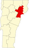
Wheelock is located in northwestern Caledonia County and is bordered by the town of Sheffield to the north, Sutton to the northeast, Lyndon to the east, Danville to the south, Stannard to the southwest, and Greensboro to the west. According to the United States Census Bureau, the town has a total area of 39.8 square miles (103.1 km2), of which 39.5 square miles (102.3 km2) is land and 0.31 square miles (0.8 km2), or 0.80%, is water. [6]

The highest point in town is Wheelock Mountain, with an elevation of 2,782 feet (848 m). [7]

Demographics

Historical population
CensusPop.Note
1790 33
1800 5681,621.2%
1810 96469.7%
1820 906−6.0%
1830 834−7.9%
1840 8815.6%
1850 855−3.0%
1860 832−2.7%
1870 822−1.2%
1880 8290.9%
1890 596−28.1%
1900 567−4.9%
1910 500−11.8%
1920 5265.2%
1930 412−21.7%
1940 293−28.9%
1950 287−2.0%
1960 246−14.3%
1970 238−3.3%
1980 44486.6%
1990 4818.3%
2000 62129.1%
2010 81130.6%
2020 759−6.4%
U.S. Decennial Census [8]

As of the census [1] of 2000, there were 621 people, 238 households, and 178 families residing in the town. The population density was 15.7 people per square mile (6.1/km2). There were 321 housing units at an average density of 8.1 per square mile (3.1/km2). The racial makeup of the town was 97.58% White, 0.32% Native American, 0.16% Asian, 1.29% from other races, and 0.64% from two or more races.

There were 238 households, out of which 32.4% had children under the age of 18 living with them, 64.3% were married couples living together, 5.9% had a female householder with no husband present, and 24.8% were non-families. 19.3% of all households were made up of individuals, and 7.1% had someone living alone who was 65 years of age or older. The average household size was 2.61 and the average family size was 2.96.

In the town, the population was spread out, with 25.9% under the age of 18, 6.0% from 18 to 24, 28.0% from 25 to 44, 30.4% from 45 to 64, and 9.7% who were 65 years of age or older. The median age was 40 years. For every 100 females, there were 98.4 males. For every 100 females age 18 and over, there were 100.0 males.

The median income for a household in the town was $35,750, and the median income for a family was $40,625. Males had a median income of $30,417 versus $21,667 for females. The per capita income for the town was $15,440. About 4.9% of families and 8.2% of the population were below the poverty line, including 7.4% of those under age 18 and 18.3% of those age 65 or over.

Notable people

Related Research Articles

<span class="mw-page-title-main">Essex County, Vermont</span> County in Vermont, United States

Essex County is a county located in the northeastern part of the U.S. state of Vermont. As of the 2020 census, the population was 5,920, making it the least-populous county in both Vermont and New England. Its shire town is the municipality of Guildhall. The county was created in 1792 and organized in 1800. Bordered by the Connecticut River next to New Hampshire, Essex County is south of the Canadian province of Quebec. It is the county with the lowest household-income in Vermont.

<span class="mw-page-title-main">Caledonia County, Vermont</span> County in Vermont, United States

Caledonia County is a county located in the northeastern part of the U.S. state of Vermont. As of the 2020 census, the population was 30,233. Its shire town is the town of St. Johnsbury. The county was created in 1792 and organized in 1796. It was given the Latin name for Scotland, in honor of the many settlers who claimed ancestry there.

<span class="mw-page-title-main">Windham, Connecticut</span> Town in Connecticut, United States

Windham is a town in Windham County, Connecticut, United States. It contains the former city of Willimantic as well as the boroughs of Windham Center, North Windham, and South Windham. Willimantic, an incorporated city since 1893, was consolidated with the town in 1983. The town is part of the Southeastern Connecticut Planning Region. The population was 24,428 at the 2020 census.

<span class="mw-page-title-main">Burke, Vermont</span> Town in Vermont, United States

Burke is a town in Caledonia County, Vermont, United States. The population was 1,651 at the 2020 census. The town contains the villages of East Burke, West Burke and Burke Hollow. The town is home to Burke Mountain and Burke Mountain Academy.

<span class="mw-page-title-main">Danville, Vermont</span> Town in Vermont, United States

Danville is a town in Caledonia County, Vermont, United States. The population was 2,335 at the 2020 census. The primary settlement in town is recorded as the Danville census-designated place (CDP) and had a population of 385 at the 2020 census.

<span class="mw-page-title-main">Groton, Vermont</span> Town in Vermont, United States

Groton is a town in Caledonia County, Vermont, United States. The population was 984 at the 2020 census. It contains the places Groton Pond, Rickers Mills, Rickers and West Groton. The unincorporated village of Groton in the southeast corner of town is recorded as the Groton census-designated place (CDP), with a population of 419 at the 2020 census.

<span class="mw-page-title-main">Kirby, Vermont</span> Town in Vermont, United States

Kirby is a town in Caledonia County, Vermont, United States. The population was 575 at the 2020 census.

<span class="mw-page-title-main">Lyndon, Vermont</span> Town in Vermont, United States

Lyndon is a town in Caledonia County, Vermont, United States. As of the 2020 census, the population was 5,491. Lyndon is the home of Lyndon State College. The town contains one incorporated village, Lyndonville, and four unincorporated villages: Lyndon Corner in the south, Lyndon Center in the center of town on the west side of Lyndonville, Little Egypt in the north, and East Lyndon in the southeast.

<span class="mw-page-title-main">Newark, Vermont</span> Town in Vermont, United States

Newark is a town in Caledonia County, Vermont, United States. The population was 584 at the 2020 census.

<span class="mw-page-title-main">Sheffield, Vermont</span> Town in Vermont, United States

Sheffield is a town in Caledonia County, Vermont, United States. The population was 682 at the 2020 census.

<span class="mw-page-title-main">Stannard, Vermont</span> Town in Vermont, United States

Stannard is a town in Caledonia County, Vermont. The population was 208 at the 2020 census. The town has no paved roads.

<span class="mw-page-title-main">Sutton, Vermont</span> Town in Vermont, United States

Sutton is a town in Caledonia County, Vermont, United States. The population was 913 at the 2020 census.

<span class="mw-page-title-main">Walden, Vermont</span> Town in Vermont, United States

Walden is a town in Caledonia County, Vermont, United States. The population was 956 at the 2020 census. The community has no ZIP code of its own; mail is routed through the West Danville and East Hardwick post offices.

<span class="mw-page-title-main">Waterford, Vermont</span> Town in Vermont, United States

Waterford is a town in Caledonia County, Vermont, United States. The population was 1,268 at the 2020 census.

<span class="mw-page-title-main">Brighton, Vermont</span> Town in Vermont, United States

Brighton is a town in Essex County, Vermont, United States. The population was 1,157 at the 2020 census. The town was named "Gilead" in its original grant in 1780. The town was sold to a group consisting primarily of soldiers commanded by Colonel Joseph Nightingale and subsequently named "Random". The town's name was finally changed by the legislature to "Brighton" in 1832. The Brighton village of Island Pond gets its name from the Abenaki word Menanbawk, which literally means island pond.

<span class="mw-page-title-main">Brunswick, Vermont</span> Town in Vermont, United States

Brunswick is a town in Essex County, Vermont, United States. The town was named after Prince Karl Wilhelm Ferdinand of Brunswick-Lunenburg. The population was 88 at the 2020 census. It is part of the Berlin, NH–VT Micropolitan Statistical Area. Brunswick is home to six mineral springs that made the town a popular resort destination in the 19th century. The land the springs are on is now owned by the Abenaki people.

<span class="mw-page-title-main">Georgia, Vermont</span> Town in Vermont, United States

Georgia is a town in Franklin County, Vermont, United States. The population was 4,845 at the 2020 census.

<span class="mw-page-title-main">Mount Tabor, Vermont</span> Town in Vermont, United States

Mount Tabor is a town in Rutland County, Vermont, United States. The population was 210 at the 2020 census.

Hanover is a census-designated place (CDP) and the main village in the town of Hanover in Grafton County, New Hampshire, United States. The population of the CDP was 9,078 at the 2020 census, out of 11,870 in the entire town. The CDP includes the campus of Dartmouth College.

<span class="mw-page-title-main">Cambridge, Vermont</span> Town in Vermont, United States

Cambridge is a town in Lamoille County, Vermont, United States. The population was 3,839 at the 2020 United States Census. Cambridge includes the villages of Jeffersonville and Cambridge.

References

  1. 1 2 "U.S. Census website". United States Census Bureau . Retrieved January 31, 2008.
  2. "US Board on Geographic Names". United States Geological Survey. October 25, 2007. Retrieved January 31, 2008.
  3. "Census - Geography Profile: Wheelock town, Caledonia County, Vermont". United States Census Bureau . Retrieved January 7, 2022.
  4. Albright, Charlotte. "Live In Wheelock? Get A Free Ride To Dartmouth, Which Used To Own The Town". www.vpr.org. Vermont Public Radio (VPR). Retrieved April 21, 2022.
  5. Ramer, Holly. "Dartmouth, rural Vermont town have tuition agreement spanning generations". www.foxnews.com. Fox News. Retrieved April 21, 2022.
  6. "Geographic Identifiers: 2010 Demographic Profile Data (G001): Wheelock town, Caledonia County, Vermont". U.S. Census Bureau, American Factfinder. Archived from the original on February 12, 2020. Retrieved February 6, 2013.
  7. U.S. Geological Survey Stannard, VT 7.5-minute quadrangle, 1986.
  8. "U.S. Decennial Census". United States Census Bureau. Retrieved May 16, 2015.
  9. Bigelow, Walter J. (1919). Vermont, Its Government. Montpelier, VT: Historical Publishing Company. p. 14.

Commons-logo.svg Media related to Wheelock, Vermont at Wikimedia Commons