Ryegate, Vermont

Last updated
Ryegate, Vermont
RyegateVT WhitehillHouse.jpg
Ryegate vt highlight.png
Ryegate, Vermont
Usa edcp location map.svg
Red pog.svg
Ryegate, Vermont
Location in the United States
Coordinates: 44°12′36″N72°6′2″W / 44.21000°N 72.10056°W / 44.21000; -72.10056 Coordinates: 44°12′36″N72°6′2″W / 44.21000°N 72.10056°W / 44.21000; -72.10056
Country United States
State Vermont
County Caledonia
Chartered1763
Communities East Ryegate
Ryegate Corner
South Ryegate
Area
  Total36.8 sq mi (95.2 km2)
  Land36.5 sq mi (94.5 km2)
  Water0.3 sq mi (0.8 km2)
Elevation
1,257 ft (383 m)
Population
 (2020)
  Total1,167
  Density32/sq mi (12.3/km2)
Time zone UTC-5 (Eastern (EST))
  Summer (DST) UTC-4 (EDT)
ZIP code
05042, 05069
Area code 802
FIPS code 50-61525 [1]
GNIS feature ID1462195 [2]
Website www.ryegatevt.org

Ryegate is a town in Caledonia County, Vermont, United States. The population was 1,165 at the 2020 census. [3] The town contains the villages of South Ryegate, East Ryegate, and Ryegate Corner.

Contents

History

South Ryegate in 1909 View of South Ryegate, VT.jpg
South Ryegate in 1909

One of the New Hampshire Grants, it was chartered by Governor Benning Wentworth on September 8, 1763. Granted to Richard Jenness and 93 others, it was named Ryegate, a variant spelling of Reigate in Surrey, England. The first settlers were Aaron Hosmer and his family. Sold to John Witherspoon and others, the southern half of town was purchased in 1773 by two agents for the Scotch American Company of Farmers from Renfrew and Lanark, Scotland, whose members began settlement in 1774.

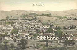
The town had excellent soil for the cultivation of grains, vegetables and orchards. Streams teemed with salmon and trout. Hills and valleys provided pasturage for grazing sheep and cattle. Connected in 1847 to the Connecticut & Passumpsic Rivers Railroad, the town by 1859 was noted for producing butter and leather. The Wells River supplied water power for one gristmill and five sawmills. In 1873, the Montpelier & Wells River Railroad was completed. In 1890, a big brickyard opened; then in 1906, the Ryegate Paper Company began operation. But the town's dominant industry was six granite quarries at Blue Mountain.

Geography

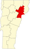
According to the United States Census Bureau, the town has a total area of 36.8 square miles (95.2 km2), of which 36.5 square miles (94.5 km2) is land and 0.31 square miles (0.8 km2), or 0.80%, is water. Bounded on the east by the Connecticut River (the boundary between Vermont and New Hampshire), Ryegate is drained by the Wells River. Blue Mountain, the highest point in the town, has an elevation of 2,192 feet (668 m) above sea level. [4]

The town is crossed by Interstate 91, U.S. Route 5, and U.S. Route 302. It is bordered by the town of Newbury to the south, Groton to the west, and Barnet to the north. To the east, across the Connecticut River lies Bath, New Hampshire.

Demographics

Historical population
CensusPop.Note
1790 187
1800 406117.1%
1810 812100.0%
1820 99422.4%
1830 1,11912.6%
1840 1,2229.2%
1850 1,60631.4%
1860 1,098−31.6%
1870 935−14.8%
1880 1,04611.9%
1890 1,1267.6%
1900 995−11.6%
1910 1,19420.0%
1920 1,188−0.5%
1930 1,2162.4%
1940 1,105−9.1%
1950 996−9.9%
1960 894−10.2%
1970 830−7.2%
1980 1,00020.5%
1990 1,0585.8%
2000 1,1508.7%
2010 1,1742.1%
2020 1,165−0.8%
U.S. Decennial Census [5]

As of the census [1] of 2000, there were 1,150 people, 435 households, and 324 families residing in the town. The population density was 31.4 people per square mile (12.1/km2). There were 564 housing units at an average density of 15.4 per square mile (6.0/km2). The racial makeup of the town was 98.35% White, 0.09% African American, 0.43% Native American, 0.35% Asian, and 0.78% from two or more races. Hispanic or Latino of any race were 0.17% of the population.

There were 435 households, out of which 31.3% had children under the age of 18 living with them, 61.8% were married couples living together, 7.4% had a female householder with no husband present, and 25.3% were non-families. 19.8% of all households were made up of individuals, and 7.8% had someone living alone who was 65 years of age or older. The average household size was 2.64 and the average family size was 3.05.

In the town, the population was spread out, with 25.2% under the age of 18, 7.0% from 18 to 24, 24.6% from 25 to 44, 28.4% from 45 to 64, and 14.7% who were 65 years of age or older. The median age was 41 years. For every 100 females, there were 107.2 males. For every 100 females age 18 and over, there were 100.0 males.

The median income for a household in the town was $36,761, and the median income for a family was $41,607. Males had a median income of $26,875 versus $21,705 for females. The per capita income for the town was $17,880. About 3.3% of families and 5.9% of the population were below the poverty line, including 6.2% of those under age 18 and 5.2% of those age 65 or over.

Education

The Blue Mountain Union School (BMU) serves students from the town of Ryegate and consists of Pre-K through grade 12 housed in one building. Total enrollment for the 2017–2018 school year was 419 students. [6] BMU is located on Route 302 (Exit 17 off Interstate-91), just east from P & H Truckstop.

The Blue Mountain Union School District was formed in November 1964 merging the Wells River Graded School District, the Groton Town School District, and the Ryegate Town School District. This merger resulted in the closing of five local schools: Groton School, Wells River School, South Ryegate School, Ryegate Corner School, and East Ryegate School. The merger also removed the option for high school choice in the town of Ryegate, in favor of attending the new union high school. Although the merger was approved in 1964, there was a lengthy legal battle regarding the formation of the district, and the new district did not operate a school building until 1970. [7]

On July 1, 2018 the State Board of Education temporarily reassigned the Blue Mountain Union School District to Orange East Supervisory under the Act 46 school district consolidation law. Merger plans and implementation continue following lawsuits and local district votes. Blue Mountain is, now, a part of the Orange East Supervisory Union. [8]

Notable people

Related Research Articles

<span class="mw-page-title-main">Washington County, Vermont</span> County in Vermont, United States

Washington County is a county located in the U.S. state of Vermont. Named after George Washington, its county seat is the city of Montpelier and the most populous municipality is the city of Barre. As of the 2020 census, the population was 59,807, making it the third-most populous county in Vermont, but the third-least populous capital county in the United States after Hughes County, South Dakota and Franklin County, Kentucky. Washington County comprises the Barre, Vermont micropolitan statistical area. In 2010, the center of population of Vermont was located in Washington County, in the town of Warren.

<span class="mw-page-title-main">Orange County, Vermont</span> County in Vermont, United States

Orange County is a county located in the U.S. state of Vermont. As of the 2020 census, the population was 29,277. Its shire town is the town of Chelsea. Orange County was organized on February 2, 1781, as an original county within the state.

<span class="mw-page-title-main">Caledonia County, Vermont</span> County in Vermont, United States

Caledonia County is a county located in the northeastern part of the U.S. state of Vermont. As of the 2020 census, the population was 30,233. Its shire town is the town of St. Johnsbury. The county was created in 1792 and organized in 1796. It was given the Latin name for Scotland, in honor of the many settlers who claimed ancestry there.

<span class="mw-page-title-main">Groton, New Hampshire</span> Town in New Hampshire, United States

Groton is a town in Grafton County, New Hampshire, United States. The population was 569 at the 2020 census.

<span class="mw-page-title-main">Granville, Vermont</span> Town in Vermont, United States

Granville is a town in Addison County, Vermont, United States. The population was 301 at the 2020 census. The town was originally called Kingston but was renamed in 1833.

<span class="mw-page-title-main">Barnet, Vermont</span> Town in Vermont, United States

Barnet is a town in Caledonia County, Vermont, United States. The population was 1,663 at the 2020 census. Barnet contains the locations of Barnet Center, East Barnet, McIndoe Falls, Mosquitoville, Passumpsic and West Barnet. The main settlement of Barnet is recorded as a census-designated place by the U.S. Census Bureau, with a population of 127 at the 2020 census.

<span class="mw-page-title-main">Groton, Vermont</span> Town in Vermont, United States

Groton is a town in Caledonia County, Vermont, United States. The population was 984 at the 2020 census. It contains the places Groton Pond, Rickers Mills, Rickers and West Groton. The unincorporated village of Groton in the southeast corner of town is recorded as the Groton census-designated place (CDP), with a population of 419 at the 2020 census.

<span class="mw-page-title-main">Peacham, Vermont</span> Town in Vermont, United States

Peacham is a town in Caledonia County, Vermont, United States. The population was 715 at the 2020 census.

<span class="mw-page-title-main">Stannard, Vermont</span> Town in Vermont, United States

Stannard is a town in Caledonia County, Vermont. The population was 208 at the 2020 census. The town has no paved roads.

<span class="mw-page-title-main">Waterford, Vermont</span> Town in Vermont, United States

Waterford is a town in Caledonia County, Vermont, United States. The population was 1,268 at the 2020 census.

<span class="mw-page-title-main">Bolton, Vermont</span> Town in Vermont, United States

Bolton is a town in Chittenden County, Vermont, United States. The population was 1,301 at the time of the 2020 census. The town is home to Bolton Valley, a popular ski resort.

<span class="mw-page-title-main">Huntington, Vermont</span> Town in Vermont, United States

Huntington is a town in Chittenden County, Vermont, United States. The population was 1,938 at the 2020 census.

<span class="mw-page-title-main">Richmond, Vermont</span> Town in Vermont, United States

Richmond is a town in Chittenden County, Vermont, United States. As of the 2020 census the population was 4,167. The main settlement of Richmond, in the north-central part of town, is a census-designated place (CDP), with a population of 853 at the 2020 census; it was formerly an incorporated village.

<span class="mw-page-title-main">Clarendon, Vermont</span> Town in Vermont, United States

Clarendon is a town in Rutland County, Vermont, United States. The population was 2,412 at the 2020 census. Clarendon spans U.S. Route 7 and is split by the highway, the Cold River and Mill River, Otter Creek, and the Green Mountains into the hamlets of Clarendon, West Clarendon, East Clarendon, Clarendon Springs, and North Clarendon

<span class="mw-page-title-main">Tinmouth, Vermont</span> Town in Vermont, United States

Tinmouth is a town in Rutland County, Vermont, United States. The population was 553 at the 2020 census.

<span class="mw-page-title-main">Bethel, Vermont</span> Town in Vermont, United States

Bethel is a town in Windsor County, Vermont, United States. The population was 1,942 at the 2020 census. The town includes the locations of Bethel village, Bethel-Gilead, East Bethel, Lilliesville, Lympus, and West Bethel. Bethel is best known for being the source of Bethel White granite which was used to build Union Station and the National Museum of Natural History. Bethel was the first town created by the independent Republic of Vermont in 1779 and was named after the Biblical village of Bethel.

<span class="mw-page-title-main">Albany, Vermont</span> Town in Vermont, United States

Albany is a town in Orleans County, Vermont, United States. The population was 976 at the 2020 census. Albany contains four villages: the incorporated village of Albany, and the unincorporated villages of Albany Center, East Albany and South Albany.

<span class="mw-page-title-main">St. Johnsbury, Vermont</span> Town in Vermont, United States

St. Johnsbury is the shire town of Caledonia County, Vermont, United States. As of the 2020 census, the population was 7,364. St. Johnsbury is situated on the Passumpsic River and is located approximately six miles northwest of the Connecticut River and 48 miles (77 km) south of the Canada–U.S. border.

<span class="mw-page-title-main">Bradford, Vermont</span> Town in Vermont, United States

Bradford is a town in Orange County, Vermont, United States. The population was 2,790 at the 2020 census. Bradford is located on the county's eastern border, bordering both the Connecticut River and New Hampshire, and is a commercial center for some of its surrounding towns.

<span class="mw-page-title-main">Addison, Vermont</span> Town in Vermont, United States

Addison is a town in Addison County, Vermont, United States. It was founded October 14, 1761. The population was 1,365 at the 2020 census.

References

  1. 1 2 "U.S. Census website". United States Census Bureau . Retrieved 2008-01-31.
  2. "US Board on Geographic Names". United States Geological Survey. 2007-10-25. Retrieved 2008-01-31.
  3. "Census - Geography Profile: Ryegate town, Caledonia County, Vermont". United States Census Bureau . Retrieved January 4, 2022.
  4. U.S. Geological Survey Groton, VT 7.5-minute quadrangle, 1973.
  5. "U.S. Decennial Census". United States Census Bureau. Retrieved May 16, 2015.
  6. "Report Viewer". edw.vermont.gov. Retrieved 2018-09-23.
  7. BMUSD Annual Report 2017-18, pp 16-17
  8. "Orange East Supervisory Union Board - Orange East Supervisory Union".
  9. "Demise of Alexander Dunnett" . The Evening Argus . Montpelier, VT. September 15, 1920. p. 4 via Newspapers.com.
  10. "Longtime legislator John Zampieri dies at 80". Vermont Digger. June 13, 2021. Archived from the original on June 15, 2021.