Cornish, New Hampshire

Last updated

Cornish, New Hampshire
The Square, Cornish Flat, NH.jpg
The Square in 1917
Sullivan County New Hampshire incorporated and unincorporated areas Cornish highlighted.svg
Location of Cornish in Sullivan County, New Hampshire and of Sullivan County in New Hampshire
Coordinates: 43°27′53″N72°22′09″W / 43.46472°N 72.36917°W / 43.46472; -72.36917
Country United States
State New Hampshire
County Sullivan
Incorporated 1765
Villages
Government
   Board of Selectmen
  • Dillon Gallagher, Chair
  • Jason Bourne
  • John Hammond
Area
[1]
  Total42.6 sq mi (110.4 km2)
  Land42.0 sq mi (108.7 km2)
  Water0.7 sq mi (1.7 km2)  1.54%
Elevation
466 ft (142 m)
Population
 (2020)
  Total1,616
  Density39/sq mi (14.9/km2)
Time zone UTC−5 (Eastern)
  Summer (DST) UTC−4 (Eastern)
ZIP Codes
03745 (Cornish)
03746 (Cornish Flat)
Area code 603
FIPS code 33-15060
GNIS feature ID0873571
Website www.cornishnh.net

Cornish is a town in Sullivan County, New Hampshire, United States. The population was 1,616 at the 2020 census. [2] Cornish has four covered bridges. Each August, it is home to the Cornish Fair.

Contents

History

Blow-me-down Brook bridge in 1908, completed in 1888 Blow-me-down Bridge, Cornish, NH.jpg
Blow-me-down Brook bridge in 1908, completed in 1888
Mount Ascutney c. 1910 Mount Ascutney from High Court, Cornish, NH.jpg
Mount Ascutney c.1910

The town was granted in 1763 and contained an area once known as "Mast Camp", because it was the shipping point for the tall masts floated down the river by English settlers. It was incorporated in 1765 by colonial governor Benning Wentworth and named for Sir Samuel Cornish, a distinguished admiral of the Royal Navy. [3] Since the 1827 partition of Cheshire County, the town has been within Sullivan County.

Since the late 19th century, Cornish has been a well-known summer resort for artists and writers. Sculptor Augustus Saint-Gaudens began coming to Cornish in 1885, seeking a studio away from the summer heat of New York City. Artist friends followed him, including painter and illustrator Maxfield Parrish, who designed and built his estate, the Oaks, in the area. The surrounding area became the center of the popular Cornish Art Colony. [4] Cornish was the residence of the reclusive author J. D. Salinger from the 1950s until his death in 2010.

Until 2008, when the Smolen–Gulf Bridge opened in Ohio, Cornish had been home to the longest covered bridge (still standing) in the United States. Cornish remains home to the longest two-span covered bridge in the world. The Cornish–Windsor Covered Bridge spans the Connecticut River and was built in 1866 at an original cost of $9,000. Cornish also has three other covered bridges: the Blow-Me-Down Covered Bridge, Dingleton Hill Covered Bridge, and Kenyon Bridge.

Geography

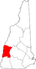
According to the United States Census Bureau, the town has a total area of 42.6 square miles (110.4 km2), of which 42.0 square miles (108.7 km2) are land and 0.66 square miles (1.7 km2) are water, comprising 1.54% of the town. [1] The Connecticut River forms the western boundary of the town, which is also the New Hampshire–Vermont border. The town is drained by direct tributaries of the Connecticut: Blow-me-down Brook, Mill Brook, and Walker Brook; and by Redwater Brook, which flows south to the Sugar River in Claremont before that river joins the Connecticut. [5] The long ridge of Croydon Mountain follows the eastern boundary of town; the highest point in town is a knob on Croydon Mountain which reaches an elevation of 2,323 ft (708 m) above sea level. [6] The eastern part of the town is a portion of the approximately 25,000-acre (100 km2) Blue Mountain Forest Association private game preserve, also known locally as Corbin Park, named after its founder, Austin Corbin.

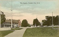
Cornish is dotted with several small villages, including Cornish Center, Cornish Flat, Cornish City, Cornish Mills, South Cornish, Balloch, and Squag City.

Cornish is served by state routes 12A and 120, both of which connect Claremont to the south with Lebanon to the north.

Adjacent municipalities

Demographics

Historical population
CensusPop.Note
1790 982
1800 1,26829.1%
1810 1,60626.7%
1820 1,7015.9%
1830 1,687−0.8%
1840 1,7262.3%
1850 1,606−7.0%
1860 1,520−5.4%
1870 1,334−12.2%
1880 1,156−13.3%
1890 954−17.5%
1900 9620.8%
1910 1,0054.5%
1920 844−16.0%
1930 8551.3%
1940 790−7.6%
1950 98925.2%
1960 1,10611.8%
1970 1,26814.6%
1980 1,3909.6%
1990 1,65919.4%
2000 1,6610.1%
2010 1,640−1.3%
2020 1,616−1.5%
U.S. Decennial Census [7]

As of the 2020 Census, the total population was 1,616, with a total of 761 housing units, 707 of which were occupied. The town's residents consisted of 1 American Indian or Alaska Native, 9 Asian, 7 Black or African American, 12 Some Other Race, 92 Two or More Races, and 1,495 White. 18 residents were Hispanic or Latino, and 1,494 Not Hispanic or Latino. As of the 2015-19 American Community Survey, 41.9% of the population had a bachelor's degree or higher. The median household income was $82,083, and the median age was 54.1, with 28.8% being age 65 or older. 8.6% were veterans. Home ownership rate was 92.6%. [8]

As of the census [9] of 2000, there were 1,661 people, 645 households, and 465 families residing in the town. The population density was 39.4 inhabitants per square mile (15.2/km2). There were 697 housing units at an average density of 16.5 per square mile (6.4/km2). The racial makeup of the town was 97.71% White, 0.30% African American, 0.30% Native American, 0.12% Asian, 0.12% Pacific Islander, 0.30% from other races, and 1.14% from two or more races. Hispanic or Latino of any race were 0.48% of the population.

There were 645 households, out of which 32.2% had children under the age of 18 living with them, 62.9% were married couples living together, 5.4% had a female householder with no husband present, and 27.8% were non-families. Of all households 21.2% were made up of individuals, and 7.4% had someone living alone who was 65 years of age or older. The average household size was 2.57 and the average family size was 3.02.

In the town, the population was spread out, with 25.9% under the age of 18, 3.8% from 18 to 24, 26.4% from 25 to 44, 31.8% from 45 to 64, and 12.2% who were 65 years of age or older. The median age was 42 years. For every 100 females, there were 100.1 males. For every 100 females age 18 and over, there were 100.2 males.

The median income for a household in the town was $53,393, and the median income for a family was $60,313. Males had a median income of $36,115 versus $29,474 for females. The per capita income for the town was $23,165. About 2.8% of families and 4.5% of the population were below the poverty line, including 5.8% of those under age 18 and 5.5% of those age 65 or over.

Sites of interest

Notable people

Related Research Articles

<span class="mw-page-title-main">Sullivan County, New Hampshire</span> County in New Hampshire, United States

Sullivan County is a county in the U.S. state of New Hampshire. As of the 2020 census, the population was 43,063, making it the second-least populous county in New Hampshire. Its county seat is Newport.

<span class="mw-page-title-main">Cornish, Maine</span> Town in the state of Maine, United States

Cornish is a town in York County, Maine, United States. The population was 1,508 at the 2020 census. It is part of the Portland–South Portland–Biddeford, Maine metropolitan statistical area. The main village in town is the Cornish census-designated place. The village has a number of antique shops and restaurants near historic Thompson Park. Cornish is home to the first concrete bridge in North America.

<span class="mw-page-title-main">Chesterfield, New Hampshire</span> Town in New Hampshire, United States

Chesterfield is a town in Cheshire County, New Hampshire, United States. The population was 3,552 at the 2020 census. It includes the villages of Spofford and West Chesterfield. Chesterfield is home to Spofford Lake, Chesterfield Gorge Natural Area, and parts of Pisgah State Park and Wantastiquet Mountain State Forest.

<span class="mw-page-title-main">Westmoreland, New Hampshire</span> Town in New Hampshire, United States

Westmoreland is a town in Cheshire County, New Hampshire, United States. The population was 1,706 at the 2020 census, down from 1,874 at the 2010 census. Westmoreland is historically an agricultural town, with much arable farmland.

<span class="mw-page-title-main">Northumberland, New Hampshire</span> Town in New Hampshire, United States

Northumberland is a town located in western Coös County, New Hampshire, U.S., north of Lancaster. It is part of the Berlin, NH–VT micropolitan statistical area. As of the 2020 census, the town population was 2,126, of whom 1,068 lived in the village of Groveton.

<span class="mw-page-title-main">Salisbury, New Hampshire</span> Town in New Hampshire, United States

Salisbury is a town in Merrimack County, New Hampshire, United States. The population was 1,422 at the 2020 census.

<span class="mw-page-title-main">Croydon, New Hampshire</span> Place in New Hampshire, United States

Croydon is a town in Sullivan County, New Hampshire, United States. The population was 801 at the 2020 census.

<span class="mw-page-title-main">Plainfield, New Hampshire</span> Place in New Hampshire, United States

Plainfield is a town in Sullivan County, New Hampshire, United States. At the time of the 2020 census, the town had a population of 2,459. The town is home to the Helen Woodruff Smith Bird Sanctuary and Annie Duncan State Forest.

<span class="mw-page-title-main">Colchester, Vermont</span> Town in Vermont, United States

Colchester is a town in Chittenden County, Vermont, United States. As of the 2020 census, the population of Colchester was 17,524. It is the third-most populous municipality and most populous town in the state of Vermont. Colchester borders Burlington, Vermont's most populous municipality. The town is directly to Burlington's north on the eastern shore of Lake Champlain, to the west of the Green Mountains. The Vermont National Guard is based in the town, and it is also home to Saint Michael's College and the Vermont campus of Southern New Hampshire University.

<span class="mw-page-title-main">Lemington, Vermont</span> Town in Vermont, United States

Lemington is a town in Essex County, Vermont, United States. The population was 87 as of the 2020 census. It is part of the Berlin, NH–VT Micropolitan Statistical Area.

<span class="mw-page-title-main">Lunenburg, Vermont</span> Town in Vermont, United States

Lunenburg is a town in Essex County, Vermont, United States. The population was 1,246 at the 2020 census, the most populous in Essex County. Lunenburg contains the villages of West Lunenburg, South Lunenburg, Mill Village and Gilman, and is part of the Berlin, NH–VT Micropolitan Statistical Area.

<span class="mw-page-title-main">Dummerston, Vermont</span> Town in Vermont, United States

Dummerston is a town in Windham County, Vermont, United States. The population was 1,865 at the 2020 census. It is home to the longest covered bridge still in use in Vermont. Its borders include three main villages: Dummerston Center, West Dummerston, and East Dummerston.

<span class="mw-page-title-main">Halifax, Vermont</span> Town in Vermont, United States

Halifax is a town in Windham County, Vermont, in the United States. As of the 2020 census, the town population was 771.

<span class="mw-page-title-main">Sharon, Vermont</span> Town in Vermont, United States

Sharon is a town in Windsor County, Vermont, United States. It had a population of 1,560 at the 2020 census.

<span class="mw-page-title-main">Windsor, Vermont</span> Town in Vermont, United States

Windsor is a town in Windsor County, Vermont, United States. As the "Birthplace of Vermont", the town is where the Constitution of Vermont was adopted in 1777, thus marking the founding of the Vermont Republic, a sovereign state until 1791, when Vermont joined the United States. Over much of its history, Windsor was home to a variety of manufacturing enterprises. Its population was 3,559 at the 2020 census.

<span class="mw-page-title-main">Winchester, New Hampshire</span> Town in New Hampshire, United States

Winchester is a town in Cheshire County, New Hampshire, United States. The population was 4,150 at the 2020 census. The primary community in the town, where 1,606 people resided at the 2020 census, is defined by the U.S. Census Bureau as the Winchester census-designated place (CDP). The town also includes the village of Ashuelot and part of Pisgah State Park.

<span class="mw-page-title-main">Littleton, New Hampshire</span> Town in New Hampshire, United States

Littleton is a town in Grafton County, New Hampshire, United States. The population was 6,005 at the 2020 census. Situated at the northern edge of the White Mountains, Littleton is bounded on the northwest by the Connecticut River.

<span class="mw-page-title-main">Newport, New Hampshire</span> Place in New Hampshire, United States

Newport is a town in and the county seat of Sullivan County, New Hampshire, United States. It is 43 miles (69 km) west-northwest of Concord, the state capital. The population of Newport was 6,299 at the 2020 census. A covered bridge is in the northwest. The area is noted for maple sugar and apple orchards. Prior to county division in 1827, Newport was in Cheshire County. The central part of town, where 4,735 people resided at the 2020 census, is defined as the Newport census-designated place (CDP) and is located next to the Sugar River at the junction of New Hampshire routes 10 and 11. The town also includes the villages of Kelleyville, Guild, and North Newport.

<span class="mw-page-title-main">Cambridge, Vermont</span> Town in Vermont, United States

Cambridge is a town in Lamoille County, Vermont, United States. The population was 3,839 at the 2020 United States Census. Cambridge includes the villages of Jeffersonville and Cambridge.

<span class="mw-page-title-main">Newfane, Vermont</span> Town in Vermont, United States

Newfane is the shire town of Windham County, Vermont, United States. The population was 1,645 at the 2020 census. The town includes the villages of Newfane, Williamsville, and South Newfane.

References

  1. 1 2 "2021 U.S. Gazetteer Files – New Hampshire". United States Census Bureau. Retrieved January 6, 2022.
  2. "Census - Geography Profile: Cornish town, Sullivan County, New Hampshire" . Retrieved December 24, 2021.
  3. Coolidge, Austin J.; John B. Mansfield (1859). A History and Description of New England. Boston, Massachusetts: A.J. Coolidge. pp.  460–461. coolidge mansfield history description new england 1859.
  4. "Cornish Arts Colony in Cornish and Plainfield, NH 1885-1930". www.crjc.org.
  5. Foster, Debra H.; Batorfalvy, Tatianna N.; Medalie, Laura (1995). Water Use in New Hampshire: An Activities Guide for Teachers. U.S. Department of the Interior and U.S. Geological Survey.
  6. The knob is unnamed on federal topographic maps, but is shown as "Buffalo Mountain" on a hand-drawn map by Ms. Gross, town historian of Croydon.
  7. "Census of Population and Housing". Census.gov. Retrieved June 4, 2016.
  8. "U.S. Census website". United States Census Bureau . Retrieved March 11, 2022.
  9. "U.S. Census website". United States Census Bureau . Retrieved January 31, 2008.
  10. Erdrich, Louise; Dorris, Michael (1994). Conversations with Louise Erdrich and Michael Dorris. Univ. Press of Mississippi. ISBN   9780878056521.
  11. Bowdoin College (1889). Obituary Record of the Graduates of Bowdoin College and the Medical School of Maine. pp. 21–22.
  12. Katie Zezima, "Cornish Journal: J. D. Salinger a Recluse? Well, Not to His Neighbors", The New York Times , January 31, 2010.
  13. Emily Jones Smith (1914). The Life and letters of Nathan Smith, M.B., M.D. Yale University Press. p. xxvi. Retrieved November 6, 2012.
  14. Wade, M; Tracy, S. P.; Wood, D. C. (1976). A brief history of Cornish,1763-1974. for the Town of Cornish by University Press of New England. ISBN   978-0-87451-129-1.