Goshen, New Hampshire

Last updated

Goshen, New Hampshire
GoshenNH TownHall.jpg
Town Hall
Sullivan County New Hampshire incorporated and unincorporated areas Goshen highlighted.svg
Location in Sullivan County and the state of New Hampshire
Coordinates: 43°18′04″N72°08′52″W / 43.30111°N 72.14778°W / 43.30111; -72.14778
Country United States
State New Hampshire
County Sullivan
Incorporated 1791
Villages
  • Goshen
  • Goshen Four Corners
Government
   Board of Selectmen
  • Dianne Craig, Chair
  • Derek Tremblay
  • Alicea Bursey
Area
[1]
  Total22.53 sq mi (58.36 km2)
  Land22.44 sq mi (58.12 km2)
  Water0.09 sq mi (0.24 km2)  0.41%
Elevation
971 ft (296 m)
Population
 (2020)
  Total796
  Density35/sq mi (13.7/km2)
Time zone UTC-5 (Eastern)
  Summer (DST) UTC-4 (Eastern)
ZIP code
03752
Area code 603
FIPS code 33-30500
GNIS feature ID0873608
Website www.goshennh.org

Goshen is a town in Sullivan County, New Hampshire, United States. The population was 796 at the 2020 census. [2]

Contents

History

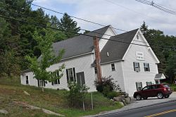
Incorporated in 1791, Goshen was first settled in 1768 as a part of Saville (now Sunapee). The name "Goshen" may have been taken from Goshen, Connecticut, where many residents had relatives.

Geography

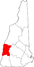
According to the United States Census Bureau, the town has a total area of 22.5 square miles (58.4 km2), of which 22.4 square miles (58.1 km2) are land and 0.1 square miles (0.2 km2) are water, comprising 0.41% of the town. [1] Goshen is drained by the South Branch Sugar River and its tributaries Blood Brook and Gunnison Brook, and hence lies almost fully within the Connecticut River watershed. Most of the southeastern part of town is drained by Cherry Brook, one of the headwaters of the Ashuelot River, a southwestward-flowing tributary of the Connecticut, but a small area at the southeastern corner of town has the headwaters of the eastward-flowing West Branch Warner River, part of the Merrimack River watershed. [3]

The long ridge of Mount Sunapee occupies the eastern edge of town. The highest point in Goshen is an unnamed knob on the ridge (near Goves Mountain) where the elevation reaches 2,529 feet (771 m) above sea level.

New Hampshire Route 10 passes through the western part of the town, including Goshen village, and leads north to Newport and south to Keene. New Hampshire Route 31 has its northern terminus at Route 10 and leads southeast to Hillsborough.

Adjacent municipalities

Demographics

Historical population
CensusPop.Note
1800 383
1810 56347.0%
1820 68722.0%
1830 77212.4%
1840 7790.9%
1850 659−15.4%
1860 576−12.6%
1870 507−12.0%
1880 5110.8%
1890 384−24.9%
1900 345−10.2%
1910 329−4.6%
1920 283−14.0%
1930 255−9.9%
1940 35238.0%
1950 3561.1%
1960 351−1.4%
1970 39512.5%
1980 54939.0%
1990 74235.2%
2000 741−0.1%
2010 8109.3%
2020 796−1.7%
U.S. Decennial Census [4]

As of the census [5] of 2000, there were 741 people, 279 households, and 219 families residing in the town. The population density was 32.9 inhabitants per square mile (12.7/km2). There were 389 housing units at an average density of 17.3 per square mile (6.7/km2). The racial makeup of the town was 97.03% White, 1.62% Native American, 0.13% Asian, 0.13% from other races, and 1.08% from two or more races. Hispanic or Latino of any race were 0.40% of the population.

There were 279 households, out of which 33.3% had children under the age of 18 living with them, 64.5% were married couples living together, 9.7% had a female householder with no husband present, and 21.5% were non-families. 17.2% of all households were made up of individuals, and 7.2% had someone living alone who was 65 years of age or older. The average household size was 2.63 and the average family size was 2.96.

In the town, the population was spread out, with 24.2% under the age of 18, 8.0% from 18 to 24, 27.5% from 25 to 44, 26.7% from 45 to 64, and 13.6% who were 65 years of age or older. The median age was 40 years. For every 100 females, there were 97.6 males. For every 100 females age 18 and over, there were 96.5 males.

The median income for a household in the town was $42,625, and the median income for a family was $45,208. Males had a median income of $33,333 versus $22,727 for females. The per capita income for the town was $20,561. About 6.9% of families and 8.8% of the population were below the poverty line, including 10.8% of those under age 18 and 21.5% of those age 65 or over.

Education

Fire station in Goshen Goshen NH Fire Department.jpg
Fire station in Goshen

Goshen and the neighboring town of Lempster maintained a combined elementary and middle school, called Goshen-Lempster Cooperative School, located in Lempster. The school served kindergarten through eighth grade. The cooperative was dissolved in June 2016. The majority of Goshen elementary and middle-school aged children now attend Newport, NH schools; the Newport school system now acts as the anchor system for Goshen students.

After eighth grade, students are given the choice of attending several neighboring high schools, including Newport High School, Sunapee Middle-High School, and Kearsarge Regional High School.

Notable person

Related Research Articles

<span class="mw-page-title-main">Sullivan County, New Hampshire</span> County in New Hampshire, United States

Sullivan County is a county in the U.S. state of New Hampshire. As of the 2020 census, the population was 43,063, making it the second-least populous county in New Hampshire. Its county seat is Newport.

<span class="mw-page-title-main">Goshen, Connecticut</span> Town in Connecticut, United States

Goshen is a town in Litchfield County, Connecticut, United States. The population was 3,150 at the 2020 census. The town is part of the Northwest Hills Planning Region.

<span class="mw-page-title-main">Chesterfield, Massachusetts</span> Town in Massachusetts, United States

Chesterfield is a rural hill town in Hampshire County, Massachusetts, United States, 26 miles (42 km) east of Pittsfield and 90 miles (140 km) west of Boston. The population was 1,186 at the 2020 census. It is part of the Springfield, Massachusetts Metropolitan Statistical Area.

<span class="mw-page-title-main">Goshen, Massachusetts</span> Town in Massachusetts, United States

Goshen is a town in Hampshire County, Massachusetts, United States. The population was 960 at the 2020 census. It is part of the Springfield, Massachusetts Metropolitan Statistical Area. The town has a rural atmosphere, with one general store, a post office, a fire station, a regional elementary school in nearby Chesterfield, and a town hall. The town encompasses both the Upper and Lower Highland lakes, Upper being a part of the D.A.R. State Forest. The Lower Highland Lake is privately held by a homeowners' association for families who own yearlong and summer properties on the lake.

<span class="mw-page-title-main">Marlow, New Hampshire</span> Town in New Hampshire, United States

Marlow is a town in Cheshire County, New Hampshire, United States. The population was 749 at the 2020 census. Marlow is home to Honey Brook State Forest.

<span class="mw-page-title-main">Danbury, New Hampshire</span> Town in New Hampshire, United States

Danbury is a town in Merrimack County, New Hampshire, United States. The population was 1,250 at the 2020 census.

<span class="mw-page-title-main">New London, New Hampshire</span> Town in New Hampshire, United States

New London is a town in Merrimack County, New Hampshire, United States. The population was 4,400 at the 2020 census. The town is the home of Colby–Sawyer College, site of the Gordon Research Conferences since 1947.

<span class="mw-page-title-main">Newbury, New Hampshire</span> Town in New Hampshire, United States

Newbury is a town in Merrimack County, New Hampshire, United States. The population was 2,172 at the 2020 census. Newbury is home to part of Lake Sunapee, including Mount Sunapee State Park Beach. Mount Sunapee Resort, a ski area in Mount Sunapee State Park, is in the west. The town includes the villages of Newbury, Blodgett Landing and South Newbury.

<span class="mw-page-title-main">Sutton, New Hampshire</span> Town in New Hampshire, United States

Sutton is a town in Merrimack County, New Hampshire, United States. The population was 1,978 at the 2020 census. Sutton includes the villages of Sutton Mills, North Sutton, South Sutton and East Sutton. North Sutton is home to Wadleigh State Park on Kezar Lake.

<span class="mw-page-title-main">Warner, New Hampshire</span> Town in New Hampshire, United States

Warner is a town in Merrimack County, New Hampshire, United States. The population was 2,937 at the 2020 census. The town is home to Magdalen College of the Liberal Arts, Rollins State Park and Mount Kearsarge State Forest.

<span class="mw-page-title-main">Wilmot, New Hampshire</span> Town in New Hampshire, United States

Wilmot is a town in Merrimack County, New Hampshire, United States. The population was 1,407 at the 2020 census. The town includes the communities of Wilmot, Wilmot Flat, and North Wilmot.

<span class="mw-page-title-main">Acworth, New Hampshire</span> Town in New Hampshire, United States

Acworth is a town in Sullivan County, New Hampshire, United States. At the 2020 census, the town had a total population of 853.

<span class="mw-page-title-main">Grantham, New Hampshire</span> Town in New Hampshire, United States

Grantham is a town in Sullivan County, New Hampshire, United States. The population was 3,404 at the 2020 census, an increase over the figure of 2,985 tabulated in 2010. The planned community of Eastman is in the eastern part of the town.

<span class="mw-page-title-main">Lempster, New Hampshire</span> Place in New Hampshire, United States

Lempster is a town in Sullivan County, New Hampshire, United States. The population was 1,118 at the 2020 census. Settlements include the town center and the village of East Lempster.

<span class="mw-page-title-main">Springfield, New Hampshire</span> Place in New Hampshire, United States

Springfield is a town in Sullivan County, New Hampshire, United States. The population was 1,259 at the 2020 census. Gile State Forest is located within the town.

<span class="mw-page-title-main">Sunapee, New Hampshire</span> Place in New Hampshire, United States

Sunapee is a town in Sullivan County, New Hampshire, United States. The population was 3,342 at the 2020 census. The town is home to part of Lake Sunapee and includes the village of Georges Mills.

<span class="mw-page-title-main">Unity, New Hampshire</span> Place in New Hampshire, United States

Unity is a town in Sullivan County, New Hampshire, United States. The population was 1,518 at the 2020 census, down from 1,671 at the 2010 census. The town includes the villages of Unity, East Unity, Quaker City, and West Unity.

<span class="mw-page-title-main">Washington, New Hampshire</span> Place in New Hampshire, United States

Washington is a town in Sullivan County, New Hampshire, United States. The population was 1,192 at the 2020 census. Situated in a hilly, rocky, forested area, and with 26 lakes and ponds, Washington is a picturesque resort area. It is home to Pillsbury State Park.

<span class="mw-page-title-main">Newport (CDP), New Hampshire</span> Census-designated place in New Hampshire, United States

Newport is a census-designated place (CDP) comprising the main village and surrounding rural land in the town of Newport, Sullivan County, New Hampshire, United States. The population of the CDP was 4,735 at the 2020 census, out of 6,299 in the entire town.

<span class="mw-page-title-main">Newport, New Hampshire</span> Place in New Hampshire, United States

Newport is a town in and the county seat of Sullivan County, New Hampshire, United States. It is 43 miles (69 km) west-northwest of Concord, the state capital. The population of Newport was 6,299 at the 2020 census. A covered bridge is in the northwest. The area is noted for maple sugar and apple orchards. Prior to county division in 1827, Newport was in Cheshire County. The central part of town, where 4,735 people resided at the 2020 census, is defined as the Newport census-designated place (CDP) and is located next to the Sugar River at the junction of New Hampshire routes 10 and 11. The town also includes the villages of Kelleyville, Guild, and North Newport.

References

  1. 1 2 "2021 U.S. Gazetteer Files – New Hampshire". United States Census Bureau. Retrieved January 7, 2022.
  2. "Census - Geography Profile: Goshen town, Sullivan County, New Hampshire" . Retrieved December 24, 2021.
  3. Foster, Debra H.; Batorfalvy, Tatianna N.; Medalie, Laura (1995). Water Use in New Hampshire: An Activities Guide for Teachers. U.S. Department of the Interior and U.S. Geological Survey.
  4. "Census of Population and Housing". Census.gov. Retrieved June 4, 2016.
  5. "U.S. Census website". United States Census Bureau . Retrieved January 31, 2008.