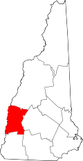
Lempster, New Hampshire

Last updated

Lempster, New Hampshire
Town Offices, Lempster NH.jpg
Lempster town offices
Sullivan County New Hampshire incorporated and unincorporated areas Lempster highlighted.svg
Location in Sullivan County and the state of New Hampshire.
Coordinates: 43°14′18″N72°12′38″W / 43.23833°N 72.21056°W / 43.23833; -72.21056
Country United States
State New Hampshire
County Sullivan
Incorporated 1772
Named for Sir Thomas Fermor, Second Baron Leominster or "Lempster"
Villages
Government
   Board of Selectmen
  • Everett Thurber
  • Mary Grenier
  • Traci Homol
Area
[1]
  Total32.7 sq mi (84.8 km2)
  Land32.4 sq mi (83.8 km2)
  Water0.4 sq mi (1.0 km2)  1.22%
Elevation
1,398 ft (426 m)
Population
 (2020)
  Total1,118
  Density34/sq mi (13.3/km2)
Time zone UTC-5 (Eastern)
  Summer (DST) UTC-4 (Eastern)
ZIP code
03605
Area code 603
FIPS code 33-41700
GNIS feature ID0873645
Website www.lempsternh.org

Lempster is a town in Sullivan County, New Hampshire, United States. The population was 1,118 at the 2020 census. [2] Settlements include the town center (Lempster village) and the village of East Lempster.

Contents

History

First granted by colonial governor Jonathan Belcher in 1735 as "Number 9" (ninth in a line of forts to guard against Indian attacks), it was regranted in 1753 as "Dupplin", after Scottish lord Thomas Hay, Viscount Dupplin, by Governor Benning Wentworth. The town was re-granted one final time in 1767 as Lempster, after Sir Thomas Fermor, Second Baron Leominster or "Lempster", [3] and incorporated in 1772.

Geography

According to the United States Census Bureau, the town has a total area of 32.7 square miles (84.8 km2), of which 32.4 square miles (83.8 km2) are land and 0.39 square miles (1.0 km2) is water, comprising 1.22% of the town. [1] The highest point in Lempster is the summit of Bean Mountain, in the eastern part of town at 2,326 feet (709 m) above sea level. Lempster lies entirely within the Connecticut River watershed. [4] The northern section of town is drained by Giles Brook, which flows north to the South Branch of the Sugar River, reaching the Connecticut River at Claremont. The western side of town is drained by the Cold River and its tributary, Dodge Brook, reaching the Connecticut in Walpole. The southeastern part of town is drained by the Ashuelot River, which flows southwest and reaches the Connecticut River at Hinsdale.

New Hampshire Route 10 traverses the town, connecting it with Goshen and Newport to the north and with Marlow, Gilsum, and Keene to the south. The village of East Lempster is located at the intersection of Route 10 and Second New Hampshire Turnpike. The village of Lempster proper is located along Second New Hampshire Turnpike, 2 miles (3 km) to the west.

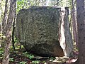
This town is home to large boulders that were likely moved by glaciers, such as those below:

Adjacent municipalities

Demographics

Historical population
CensusPop.Note
1790 415
1800 72975.7%
1810 85417.1%
1820 95011.2%
1830 9995.2%
1840 941−5.8%
1850 906−3.7%
1860 820−9.5%
1870 678−17.3%
1880 602−11.2%
1890 519−13.8%
1900 391−24.7%
1910 383−2.0%
1920 287−25.1%
1930 273−4.9%
1940 31214.3%
1950 309−1.0%
1960 272−12.0%
1970 36032.4%
1980 63776.9%
1990 94748.7%
2000 9712.5%
2010 1,15418.8%
2020 1,118−3.1%
U.S. Decennial Census [5]

As of the census [6] of 2000, there were 971 people, 387 households, and 275 families residing in the town. The 2003 census estimate for the town was 1,044 residents. The population density was 30.0 inhabitants per square mile (11.6/km2). There were 577 housing units at an average density of 17.8 per square mile (6.9/km2). The racial makeup of the town was 97.22% White, 0.10% Native American, 0.10% Asian, 0.10% Pacific Islander, and 2.47% from two or more races. Hispanic or Latino of any race were 0.21% of the population.

There were 387 households, out of which 30.5% had children under the age of 18 living with them, 59.9% were married couples living together, 7.2% had a female householder with no husband present, and 28.7% were non-families. 22.0% of all households were made up of individuals, and 9.6% had someone living alone who was 65 years of age or older. The average household size was 2.51 and the average family size was 2.90.

In the town, the population was spread out, with 24.3% under the age of 18, 5.3% from 18 to 24, 28.4% from 25 to 44, 27.9% from 45 to 64, and 14.1% who were 65 years of age or older. The median age was 41 years. For every 100 females, there were 103.6 males. For every 100 females age 18 and over, there were 105.9 males.

The median income for a household in the town was $40,458, and the median income for a family was $45,385. Males had a median income of $31,484 versus $22,566 for females. The per capita income for the town was $19,172. About 3.2% of families and 7.3% of the population were below the poverty line, including 8.0% of those under age 18 and 5.3% of those age 65 or over.

Lempster wind farm

Lempster is home to New Hampshire's first wind farm, providing a total of 24 MW from 12 turbines, which started operation in 2008. The turbines are located on Bean Mountain, a knob on the north–south ridge of Lempster Mountain ( 43°14′N72°09′W / 43.233°N 72.150°W / 43.233; -72.150 ). [7]

Notable people

Related Research Articles

<span class="mw-page-title-main">Sullivan County, New Hampshire</span> County in New Hampshire, United States

Sullivan County is a county in the U.S. state of New Hampshire. As of the 2020 census, the population was 43,063, making it the second-least populous county in New Hampshire. Its county seat is Newport.

<span class="mw-page-title-main">Chesterfield, Massachusetts</span> Town in Massachusetts, United States

Chesterfield is a rural hill town in Hampshire County, Massachusetts, United States, 26 miles (42 km) east of Pittsfield and 90 miles (140 km) west of Boston. The population was 1,186 at the 2020 census. It is part of the Springfield, Massachusetts Metropolitan Statistical Area.

<span class="mw-page-title-main">Goshen, Massachusetts</span> Town in Massachusetts, United States

Goshen is a town in Hampshire County, Massachusetts, United States. The population was 960 at the 2020 census. It is part of the Springfield, Massachusetts Metropolitan Statistical Area. The town has a rural atmosphere, with one general store, a post office, a fire station, a regional elementary school in nearby Chesterfield, and a town hall. The town encompasses both the Upper and Lower Highland lakes, Upper being a part of the D.A.R. State Forest. The Lower Highland Lake is privately held by a homeowners' association for families who own yearlong and summer properties on the lake.

<span class="mw-page-title-main">Gilsum, New Hampshire</span> Town in New Hampshire, United States

Gilsum is a town in Cheshire County, New Hampshire, United States. The population was 752 at the 2020 census. Home to Bear's Den Natural Area, Gilsum includes Gilsum Lower Village.

<span class="mw-page-title-main">Marlow, New Hampshire</span> Town in New Hampshire, United States

Marlow is a town in Cheshire County, New Hampshire, United States. The population was 749 at the 2020 census. Marlow is home to Honey Brook State Forest.

<span class="mw-page-title-main">Dummer, New Hampshire</span> Town in New Hampshire, United States

Dummer is a town in Coös County, New Hampshire, United States. The population was 306 at the 2020 census. It is part of the Berlin, NH–VT micropolitan statistical area. Dummer is home to the Pontook Reservoir, popular with canoeists, kayakers and birdwatchers. In the western part of Dummer lies the village of Paris.

<span class="mw-page-title-main">Benton, New Hampshire</span> Town in New Hampshire, United States

Benton is a town in Grafton County, New Hampshire, United States. The population was 374 at the 2020 census. Located in the White Mountains, Benton is largely surrounded by the White Mountain National Forest. The town is crossed by the Appalachian Trail.

<span class="mw-page-title-main">Dorchester, New Hampshire</span> Town in New Hampshire, United States

Dorchester is a town in Grafton County, New Hampshire, United States. The population was 339 at the 2020 census.

<span class="mw-page-title-main">Easton, New Hampshire</span> Town in New Hampshire, United States

Easton is a town in Grafton County, New Hampshire, United States. The population was 292 at the 2020 census.

<span class="mw-page-title-main">Lyman, New Hampshire</span> Town in New Hampshire, United States

Lyman is a town in Grafton County, New Hampshire, United States. The population was 585 at the 2020 census.

<span class="mw-page-title-main">Orange, New Hampshire</span> Town in New Hampshire, United States

Orange is a town in Grafton County, New Hampshire, United States. The population was 277 at the 2020 census, down from 331 at the 2010 census.

<span class="mw-page-title-main">Newbury, New Hampshire</span> Town in New Hampshire, United States

Newbury is a town in Merrimack County, New Hampshire, United States. The population was 2,172 at the 2020 census. Newbury is home to part of Lake Sunapee, including Mount Sunapee State Park Beach. Mount Sunapee Resort, a ski area in Mount Sunapee State Park, is in the west. The town includes the villages of Newbury, Blodgett Landing and South Newbury.

<span class="mw-page-title-main">South Hooksett, New Hampshire</span> Census-designated place in New Hampshire, United States

South Hooksett is a census-designated place (CDP) within the town of Hooksett in Merrimack County, New Hampshire, United States. The population was 5,888 at the 2020 census. It is a suburban area adjacent to the city of Manchester, New Hampshire's largest city, and includes a mix of housing developments and large retail stores.

<span class="mw-page-title-main">Northwood, New Hampshire</span> Place in New Hampshire, United States

Northwood is a town in Rockingham County, New Hampshire, United States. The population was 4,641 at the 2020 census.

<span class="mw-page-title-main">Acworth, New Hampshire</span> Town in New Hampshire, United States

Acworth is a town in Sullivan County, New Hampshire, United States. At the 2020 census, the town had a total population of 853.

<span class="mw-page-title-main">Goshen, New Hampshire</span> Place in New Hampshire, United States

Goshen is a town in Sullivan County, New Hampshire, United States. The population was 796 at the 2020 census.

<span class="mw-page-title-main">Springfield, New Hampshire</span> Place in New Hampshire, United States

Springfield is a town in Sullivan County, New Hampshire, United States. The population was 1,259 at the 2020 census. Gile State Forest is located within the town.

<span class="mw-page-title-main">Sunapee, New Hampshire</span> Place in New Hampshire, United States

Sunapee is a town in Sullivan County, New Hampshire, United States. The population was 3,342 at the 2020 census. The town is home to part of Lake Sunapee and includes the village of Georges Mills.

<span class="mw-page-title-main">Unity, New Hampshire</span> Place in New Hampshire, United States

Unity is a town in Sullivan County, New Hampshire, United States. The population was 1,518 at the 2020 census, down from 1,671 at the 2010 census. The town includes the villages of Unity, East Unity, Quaker City, and West Unity.

<span class="mw-page-title-main">Washington, New Hampshire</span> Place in New Hampshire, United States

Washington is a town in Sullivan County, New Hampshire, United States. The population was 1,192 at the 2020 census. Situated in a hilly, rocky, forested area, and with 26 lakes and ponds, Washington is a picturesque resort area. It is home to Pillsbury State Park.

References

  1. 1 2 "2021 U.S. Gazetteer Files – New Hampshire". United States Census Bureau. Retrieved January 10, 2022.
  2. "Census - Geography Profile: Lempster town, Sullivan County, New Hampshire" . Retrieved December 24, 2021.
  3. "Community Profiles: Lempster, New Hampshire". New Hampshire Economic & Labor Market Information Bureau. Retrieved August 12, 2022.
  4. Foster, Debra H.; Batorfalvy, Tatianna N.; Medalie, Laura (1995). Water Use in New Hampshire: An Activities Guide for Teachers. U.S. Department of the Interior and U.S. Geological Survey.
  5. "Census of Population and Housing". Census.gov. Retrieved June 4, 2016.
  6. "U.S. Census website". United States Census Bureau . Retrieved January 31, 2008.
  7. State's lone wind farm taking shape
  8. Gerard C. Wertkin (August 2, 2004). Encyclopedia of American Folk Art. Routledge. ISBN   978-1-135-95614-1.