Newport (CDP), New Hampshire

Last updated

Newport, New Hampshire
Newport Opera House, Newport NH.jpg
Newport Opera House
USA New Hampshire location map.svg
Red pog.svg
Newport
Usa edcp location map.svg
Red pog.svg
Newport
Coordinates: 43°21′52″N72°10′22″W / 43.36444°N 72.17278°W / 43.36444; -72.17278
Country United States
State New Hampshire
County Sullivan
Town Newport
Area
[1]
  Total14.11 sq mi (36.54 km2)
  Land14.11 sq mi (36.54 km2)
  Water0.00 sq mi (0.00 km2)
Elevation
817 ft (249 m)
Population
 (2020)
  Total4,735
  Density335.63/sq mi (129.59/km2)
Time zone UTC-5 (Eastern (EST))
  Summer (DST) UTC-4 (EDT)
ZIP code
03773
Area code 603
FIPS code 33-52500
GNIS feature ID2378084

Newport is a census-designated place (CDP) comprising the main village and surrounding rural land in the town of Newport, Sullivan County, New Hampshire, United States. The population of the CDP was 4,735 at the 2020 census, [2] out of 6,299 in the entire town.

Contents

Geography

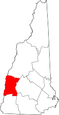
The CDP is in the eastern part of the town of Newport, with the village of Newport in the center of the CDP at the junction of the Sugar River with its South Branch. The CDP extends north to the Croydon town line, east to the Sunapee line, and south to the Unity line. From the Croydon line, the CDP border follows the North Branch of the Sugar River and then the main stem of the Sugar River southwest to New Hampshire Routes 11 and 103 in Kellyville. The border then follows NH 11/103, Whitcher Road, Bascom Road, and Unity Road to the Unity town line. A short distance to the east the CDP border follows Spring Brook east to the South Branch of the Sugar River, then turns south up the South Branch to Coon Brook Road and New Hampshire Route 10, which it follows north to Page Hill Road. It follows an unnamed stream north to Blaisdell Road, then follows East Mountain Road, Schoolhouse Road, and Bradford Road east to the Sunapee town line. The CDP runs north along the town line to Maple Street south of Wendell, then turns west on an abandoned railroad line and a power line to the Sugar River at the east edge of the urban center of Newport. Turning back to the east, the border follows the river upstream to Long Pond Brook, where it turns north, follows Routes 11/103 briefly, then takes Sand Hill Road north back to the Croydon line. [3]

New Hampshire Route 10 is Newport's Main Street, leading north 10 miles (16 km) to Interstate 89 in Grantham and south 35 miles (56 km) to Keene. Routes 11/103 lead west together 9 miles (14 km) to Claremont. The two highways lead east out of town as Sunapee Street, splitting 3 miles (5 km) east of the center of Newport in the village of Wendell. Route 11 leads northeast 5.5 miles (8.9 km) from Newport to Sunapee village, while Route 103 leads southeast 9.5 miles (15.3 km) to Newbury Harbor on Lake Sunapee.

According to the U.S. Census Bureau, the Newport CDP has a total area of 14.1 square miles (36.5 km2), all of it recorded as land. [4]

Demographics

Historical population
CensusPop.Note
1950 3,062
1960 3,2225.2%
1970 3,2962.3%
1980 4,38833.1%
1990 3,772−14.0%
2000 4,0086.3%
2010 4,76919.0%
2020 4,735−0.7%
U.S. Decennial Census [5]

As of the census of 2010, there were 4,769 people, 1,954 households, and 1,221 families residing in the CDP. There were 2,184 housing units, of which 230, or 10.5%, were vacant. The racial makeup of the CDP was 96.9% white, 0.3% African American, 0.3% Native American, 0.5% Asian, 0.0% Pacific Islander, 0.2% some other race, and 1.8% from two or more races. 1.1% of the population were Hispanic or Latino of any race. [6]

Of the 1,954 households in the CDP, 30.2% had children under the age of 18 living with them, 44.1% were headed by married couples living together, 12.5% had a female householder with no husband present, and 37.5% were non-families. 29.9% of all households were made up of individuals, and 15.1% were someone living alone who was 65 years of age or older. The average household size was 2.38, and the average family size was 2.90. [6]

22.6% of residents in the CDP were under the age of 18, 8.6% were from age 18 to 24, 23.4% were from 25 to 44, 27.9% were from 45 to 64, and 17.4% were 65 years of age or older. The median age was 41.5 years. For every 100 females, there were 91.0 males. For every 100 females age 18 and over, there were 86.9 males. [6]

For the period 2011-15, the estimated median annual income for a household was $49,486, and the median income for a family was $62,163. The per capita income for the CDP was $24,406. 8.4% of the population and 2.7% of families were below the poverty line, along with 1.3% of people under the age of 18 and 14.1% of people 65 or older. [7]

Related Research Articles

<span class="mw-page-title-main">New London, New Hampshire</span> Town in New Hampshire, United States

New London is a town in Merrimack County, New Hampshire, United States. The population was 4,400 at the 2020 census. The town is the home of Colby–Sawyer College, site of the Gordon Research Conferences since 1947.

<span class="mw-page-title-main">Newbury, New Hampshire</span> Town in New Hampshire, United States

Newbury is a town in Merrimack County, New Hampshire, United States. The population was 2,172 at the 2020 census. Newbury is home to part of Lake Sunapee, including Mount Sunapee State Park Beach. Mount Sunapee Resort, a ski area in Mount Sunapee State Park, is in the west. The town includes the villages of Newbury, Blodgett Landing and South Newbury.

<span class="mw-page-title-main">Goshen, New Hampshire</span> Place in New Hampshire, United States

Goshen is a town in Sullivan County, New Hampshire, United States. The population was 796 at the 2020 census.

<span class="mw-page-title-main">Sunapee, New Hampshire</span> Place in New Hampshire, United States

Sunapee is a town in Sullivan County, New Hampshire, United States. The population was 3,342 at the 2020 census. The town is home to part of Lake Sunapee and includes the village of Georges Mills.

<span class="mw-page-title-main">Winchester (CDP), New Hampshire</span> Census-designated place in New Hampshire, United States

Winchester is a census-designated place (CDP) and the main village in the town of Winchester in Cheshire County, New Hampshire, United States. The population of the CDP was 1,606 at the 2020 census, compared to 4,150 in the entire town.

Whitefield is a census-designated place (CDP) and the main village in the town of Whitefield in Coos County, New Hampshire, United States. The population of the CDP was 1,460 at the 2020 census, out of 2,490 people in the entire town of Whitefield.

Hanover is a census-designated place (CDP) and the main village in the town of Hanover in Grafton County, New Hampshire, United States. The population of the CDP was 9,078 at the 2020 census, out of 11,870 in the entire town. The CDP includes the campus of Dartmouth College.

<span class="mw-page-title-main">Greenville (CDP), New Hampshire</span> Census-designated place in New Hampshire, United States

Greenville is a census-designated place (CDP) and the main village in the town of Greenville in Hillsborough County, New Hampshire, United States. The population of the CDP was 1,074 at the 2020 census, out of 1,974 in the entire town.

<span class="mw-page-title-main">Hudson (CDP), New Hampshire</span> Census-designated place in New Hampshire, United States

Hudson is a census-designated place (CDP) and the urban center of the town of Hudson in Hillsborough County, New Hampshire, United States. The population of the CDP was 7,534 at the 2020 census, out of 25,394 in the entire town.

<span class="mw-page-title-main">Epping (CDP), New Hampshire</span> Census-designated place in New Hampshire, United States

Epping is a census-designated place (CDP) and the main village in the town of Epping, Rockingham County, New Hampshire, United States. The population of the CDP was 2,693 at the 2020 census, out of 7,125 in the entire town.

<span class="mw-page-title-main">Exeter (CDP), New Hampshire</span> Census-designated place in New Hampshire, United States

Exeter is a census-designated place (CDP) and the main village in the town of Exeter, Rockingham County, New Hampshire, United States. The population of the CDP was 10,109 at the 2020 census, out of 16,049 in the entire town.

<span class="mw-page-title-main">Londonderry (CDP), New Hampshire</span> Census-designated place in New Hampshire, United States

Londonderry is a census-designated place (CDP) within the town of Londonderry in Rockingham County, New Hampshire, United States. The population of the CDP was 11,645 at the 2020 census, out of 25,826 in the entire town.

<span class="mw-page-title-main">Newmarket (CDP), New Hampshire</span> Census-designated place in New Hampshire, United States

Newmarket is a census-designated place (CDP) and the main village in the town of Newmarket in Rockingham County, New Hampshire, United States. The population of the CDP was 5,797 at the 2020 census, out of 9,430 in the entire town.

<span class="mw-page-title-main">Raymond (CDP), New Hampshire</span> Census-designated place in New Hampshire, United States

Raymond is a census-designated place (CDP) and the main village in the town of Raymond, Rockingham County, New Hampshire, United States. The population of the CDP was 3,738 at the 2020 census, out of 10,684 in the entire town.

<span class="mw-page-title-main">Newport, New Hampshire</span> Place in New Hampshire, United States

Newport is a town in and the county seat of Sullivan County, New Hampshire, United States. It is 43 miles (69 km) west-northwest of Concord, the state capital. The population of Newport was 6,299 at the 2020 census. A covered bridge is in the northwest. The area is noted for maple sugar and apple orchards. Prior to county division in 1827, Newport was in Cheshire County. The central part of town, where 4,735 people resided at the 2020 census, is defined as the Newport census-designated place (CDP) and is located next to the Sugar River at the junction of New Hampshire routes 10 and 11. The town also includes the villages of Kelleyville, Guild, and North Newport.

<span class="mw-page-title-main">New Hampshire Route 11</span> State highway in central New Hampshire, US

New Hampshire Route 11 is a 108.223-mile-long (174.168 km) east–west state highway in New Hampshire, running completely across the central part of the state. Its western terminus is at the Vermont state line in Charlestown, where it continues west as Vermont Route 11. The eastern terminus is at the Maine state line in Rochester, where it crosses the border with U.S. Route 202 and continues as Maine State Route 11.

<span class="mw-page-title-main">New Hampshire Route 103</span> State highway in New Hampshire, US

New Hampshire Route 103 is a 48.300-mile-long (77.731 km) east–west highway in west-central New Hampshire, United States. The highway runs from Claremont, at the Vermont border on the Connecticut River, to Hopkinton, west of Concord.

<span class="mw-page-title-main">Bennington (CDP), New Hampshire</span> Census-designated place in New Hampshire, United States

Bennington is a census-designated place (CDP) and the main village in the town of Bennington in Hillsborough County, New Hampshire, United States. The population of the CDP was 338 at the 2020 census, out of 1,501 in the entire town.

<span class="mw-page-title-main">Bradford (CDP), New Hampshire</span> Census-designated place in New Hampshire, United States

Bradford is a census-designated place (CDP) and the main village in the town of Bradford in Merrimack County, New Hampshire, United States. The population of the CDP was 372 at the 2020 census, out of 1,662 in the entire town.

<span class="mw-page-title-main">Colebrook (CDP), New Hampshire</span> Census-designated place in New Hampshire, United States

Colebrook is a census-designated place (CDP) and the main village in the town of Colebrook, Coös County, New Hampshire, United States. The population of the CDP was 1,201 at the 2020 census, out of 2,084 in the entire town. The CDP population had dropped from 1,394 at the 2010 census.

References

  1. "ArcGIS REST Services Directory". United States Census Bureau. Retrieved September 20, 2022.
  2. "Newport CDP, New Hampshire: 2020 DEC Redistricting Data (PL 94-171)". U.S. Census Bureau. Retrieved January 10, 2022.
  3. "TIGERweb: Newport CDP, New Hampshire". Geography Division, U.S. Census Bureau. Retrieved January 26, 2021.
  4. "2021 U.S. Gazetteer Files – New Hampshire". United States Census Bureau. Retrieved January 10, 2022.
  5. "Decennial Census Official Publications". Census.gov. Retrieved March 4, 2024.
  6. 1 2 3 "Profile of General Population and Housing Characteristics: 2010 Census Summary File 1 (DP-1): Newport CDP, New Hampshire". American Factfinder. U.S. Census Bureau. Archived from the original on February 13, 2020. Retrieved October 6, 2017.
  7. "Selected Economic Characteristics: 2011-2015 American Community Survey 5-Year Estimates (DP03): Newport CDP, New Hampshire". American Factfinder. U.S. Census Bureau. Archived from the original on February 13, 2020. Retrieved October 6, 2017.